The United Kingdom is full of abandoned places: a brutalist seminary rotting in a Scottish wood, a Rothschild palace left empty on the edge of the Vale of Aylesbury, a Victorian asylum slowly collapsing outside Lincoln, a slate quarry flooded into a black lake in Snowdonia, and a Troubles-era prison frozen behind its own walls near Belfast. Our map lists over 6,000 geolocated abandoned places in the UK alone, spread across England, Scotland, Wales and Northern Ireland, and it is from this pool that we drew.
In this guide we have selected 10 abandoned places in the UK to explore in 2026: derelict country houses and ruined castles, disused asylums and hospitals, an industrial power station, a deserted village, abandoned transport infrastructure and one of the most charged sites in modern British history. Each one was verified individually: we kept only places that are genuinely abandoned, still standing and not turned into a museum or hotel as of summer 2026. Below most entries, an "Add to my map" button saves the GPS coordinates to your personal account, free of charge and with no credit card.
The terms abandoned places UK, lost places, derelict buildings, urbex (short for urban exploration) and abandoned buildings near me all point to the same passion: finding, photographing and documenting the buildings that no one occupies any more and that nature is quietly taking back. Whether you are after an abandoned asylum in England, an abandoned castle in Scotland, an abandoned mansion in Wales or an abandoned prison in Northern Ireland, this ranking covers all four nations of the UK.
See thousands of abandoned places across the UK on the interactive urbex map →
Free urbex UK: why Urbex Maps changes the game
Most lists of "abandoned places in the UK" promise free coordinates in their title, then send you off to a closed Facebook group, a forum, or a paywall. We do the opposite. Below most of the ten places that follow, you will find a real spot from our database, with a button that drops the GPS coordinates into your profile for free. No subscription, no credit card, no hidden conditions.
Behind this promise lies a verification model. A community of more than 40,000 explorers has been logging places since 2021, and every set of coordinates is checked at least twice: once by the person reporting the spot, and once by a regional moderation team that confirms the place still exists. The spots offered in this guide come from that catalogue; the rest, thousands of other British places, is available through themed packs that fund the moderation work.
This ranking is ordered by visual impact and historical weight, not by nation. We open with the most charged site of the list, then move through a modernist ruin, a deserted village, abandoned country houses, an asylum, an industrial landmark, a flooded quarry and a railway tunnel. For each place, a link points to the corresponding regional map. And one honest caveat: many of the places below are private property, listed buildings or live military land. Exploring does not mean breaking in: you look, you photograph from authorised access points, you force nothing and you damage nothing.
What is NOT on this list (and why)
When you search for "abandoned places UK" on Google, you quickly come across names that are no longer real urbex spots. We deliberately left them out, after checking. Crumlin Road Gaol in Belfast, often called an abandoned prison, has been a restored visitor attraction since 2012, with tours, a bar and concerts. Gwrych Castle in Conwy, long a famous ruin, has been stabilised and now hosts events and the TV show filmed there. The North Wales Hospital in Denbigh, the country's most legendary abandoned asylum, entered a 107 million pound, twelve-year redevelopment with the first demolitions approved in 2025: it is being turned into housing, not left to rot.
The same goes for several icons of British urbex: Pyestock (the National Gas Turbine Establishment in Hampshire) was completely demolished and is now a distribution park, Polphail ghost village in Argyll was knocked down in 2016, and Birnbeck Pier at Weston-super-Mare is under an active multi-million-pound restoration. A place earns its spot in this ranking only if it is genuinely abandoned in 2026, still standing and not turned into a museum, a hotel or a building site. That is what sets us apart from the copy-and-paste lists that have been passing around the same out-of-date names for years.
1. HMP Maze (Long Kesh): the abandoned prison of the Troubles
Near Lisburn, on a former RAF airfield in Lisburn and Castlereagh, the Maze prison, known as Long Kesh, is the most charged abandoned place in the United Kingdom. Opened on 9 August 1971, it became the maximum-security prison for paramilitary inmates during the Troubles. Its eight H-Blocks were the scene of the 1981 republican hunger strikes, in which Bobby Sands and nine other men died, and of the mass IRA escape of 1983. It held up to around 1,700 prisoners.
The Maze closed on 29 September 2000, after the Good Friday Agreement, and most of the complex was demolished from 2006. But one complete H-Block, the prison hospital, a chapel, watchtowers and a long stretch of the perimeter wall are listed and still standing, sitting empty behind the fences. Plans for a peace and conflict-transformation centre remain politically deadlocked, so the surviving buildings stay derelict, filmed by drone explorers in 2024. Access is forbidden: this is a site to understand, not to break into. See our Lisburn and Castlereagh urbex map.
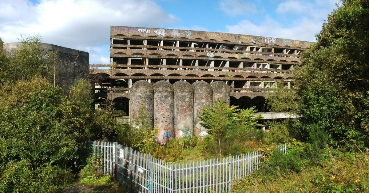
2. St Peter's Seminary: the brutalist ruin of Cardross
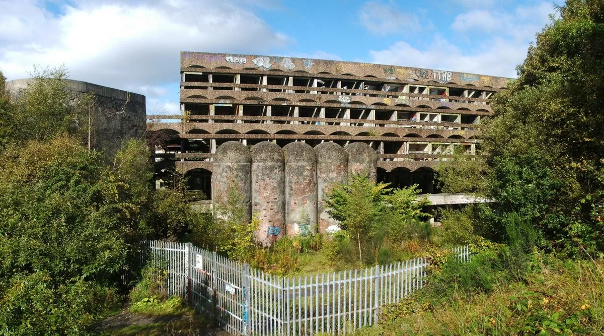
In Kilmahew woods, just north of Cardross in Argyll and Bute, the St Peter's Seminary is the most famous modern ruin in Scotland. Built between 1961 and 1966 by the architects Isi Metzstein and Andy MacMillan, of the firm Gillespie, Kidd and Coia, in a Le Corbusier-influenced concrete style, it was a Roman Catholic college for training priests. It functioned for barely fourteen years.
Falling vocations closed the seminary in 1980; it served briefly as a drug-rehabilitation centre, then was fully abandoned by 1987. Despite being Category A listed and named by Docomomo a modern building of world significance, it has decayed through water, fire and vandalism into the cathedral-like concrete shell explorers know today. A short-lived arts project in 2016 came and went, and Historic Environment Scotland has estimated it would cost more than 13 million pounds just to stabilise. It remains a roofless ruin, drone-filmed as recently as 2023. More places on our Argyll and Bute urbex map.
3. Imber: the deserted village of Salisbury Plain
In the middle of Salisbury Plain, in Wiltshire, the village of Imber is the most famous ghost village in England. It was recorded in 967 and appears in the Domesday Book of 1086. On 1 November 1943, its roughly 150 residents were given 47 days to leave so that American troops could practise street fighting before D-Day. They were never allowed back.
The Ministry of Defence has held Imber ever since and uses it as an urban-warfare training ground, with mock buildings standing among the genuine ruins. The medieval church of St Giles, Grade I listed, is preserved by the Churches Conservation Trust, while the cottages and Imber Court are empty shells. The village opens to the public only on a handful of days each year, usually around Christmas and the August bank holiday, when explorers and former residents drive in along the military road. Plan around those dates and never stray onto the range. More spots on our Wiltshire urbex map.
4. Mentmore Towers: the abandoned Rothschild palace
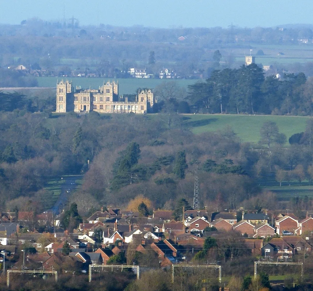
At Mentmore, near Cheddington in Buckinghamshire, the Mentmore Towers is a Jacobethan palace built between 1852 and 1854 for Baron Mayer de Rothschild, to designs by Sir Joseph Paxton and George Henry Stokes. It was one of the first country houses in the world with central heating, and it housed a celebrated art collection. It passed to the Earls of Rosebery, was sold to the Maharishi Foundation in 1978, and then to the developer Simon Halabi in 1999.
Halabi planned to turn it into a six-star hotel, but the project never happened and he went bankrupt in 2010. The house has been empty and decaying ever since, used only occasionally for filming. Historic England lists it as Heritage at Risk in "very bad" condition, Priority A, meaning immediate risk of further rapid deterioration, with no agreed rescue as of 2025. The Grade I house and its Grade II-star landscape are both at risk. Private property, to be admired from the surrounding footpaths. See our Buckinghamshire urbex map.
5. St John's Hospital: the abandoned Lincolnshire asylum
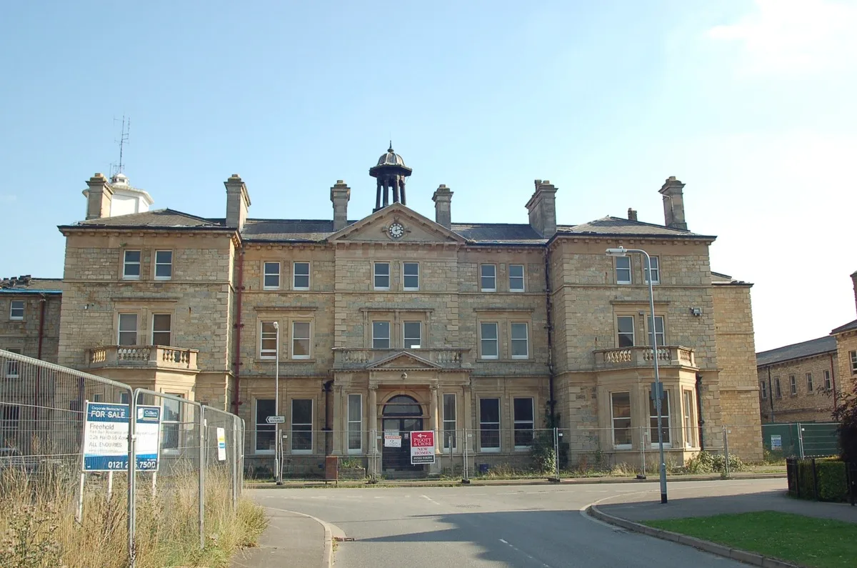
At Bracebridge Heath, just south of Lincoln in Lincolnshire, St John's Hospital is one of the great abandoned asylums of England. It opened in 1852 as the Lincolnshire County Lunatic Asylum, designed by John Hamilton and James Medland in an Italianate style, and was expanded in 1889 to hold around 680 patients. Renamed several times, it became St John's Hospital in 1961 and closed in December 1989.
The surrounding grounds were redeveloped into housing from 2014, but the Grade II listed main asylum block was left unconverted and has been decaying for more than thirty years, a long-running magnet for explorers. The listing protects it from demolition, which is exactly why it still stands while so many English asylums, West Park, Severalls, Whittingham, have been flattened. Watched and fenced, it is a place to document with care, not to break into. More abandoned places on our Lincolnshire urbex map.
6. Willington cooling towers: the Five Sisters of Derbyshire
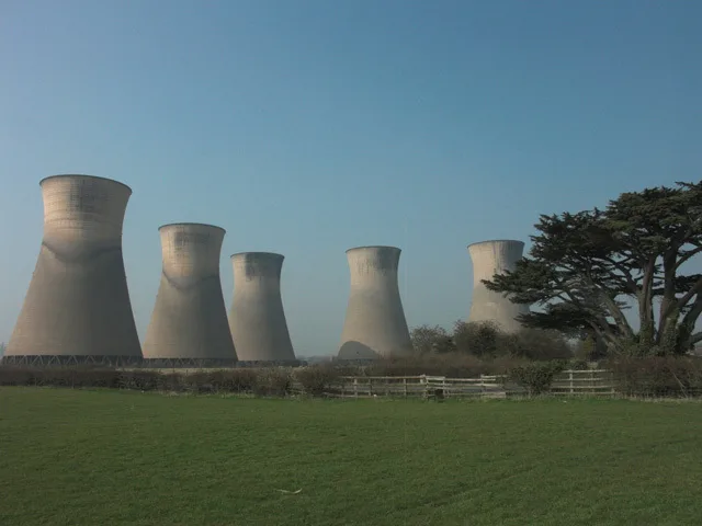
At Willington, near Findern in Derbyshire, five vast concrete cooling towers rise 300 feet above the Trent valley, nicknamed the Five Sisters. They are all that remains of Willington Power Station, two coal-fired stations run by the CEGB. Willington A was commissioned in December 1957 and Willington B in June 1962, with a combined output of around 800 megawatts.
Station A closed in 1995 and Station B in 1999, and the buildings were cleared around 2000, leaving only the hyperboloid towers as a regional landmark. Demolition has been granted and then abandoned repeatedly, a 2017 demolition lapsed and a planned gas station stalled, while a Certificate of Immunity from Listing ran from 2020 to 2025. For now they still stand, endlessly photographed by drone and FPV explorers through the 2020s. They are best appreciated from a distance, on the surrounding lanes. See our Derbyshire urbex map.
7. Buchanan Castle: the roofless baronial shell near Loch Lomond
About a mile west of Drymen, near the southern tip of Loch Lomond in Stirling, the Buchanan Castle is a Scottish-Baronial country house designed by William Burn and built between 1852 and 1858 for the 4th Duke of Montrose, head of Clan Graham. It replaced an earlier Buchanan House that had burned down in 1852, and it was the ducal seat until the family sold the estate in 1925.
The castle became a hotel, then in the Second World War a military hospital that briefly held Rudolf Hess after his flight to Scotland in 1941. The Army left in 1946 and, to avoid taxation, the roof was removed in 1954, beginning the slow ruin you see now: walls still standing to full height but steadily swallowed by trees. It is Category B listed and on the Buildings at Risk Register for Scotland, ringed by safety fencing and "danger" signs, and still described as a derelict ruin in early 2026. Look from outside the fence only. More spots on our Stirling urbex map.
8. Dorothea Quarry: the flooded slate quarry of Snowdonia
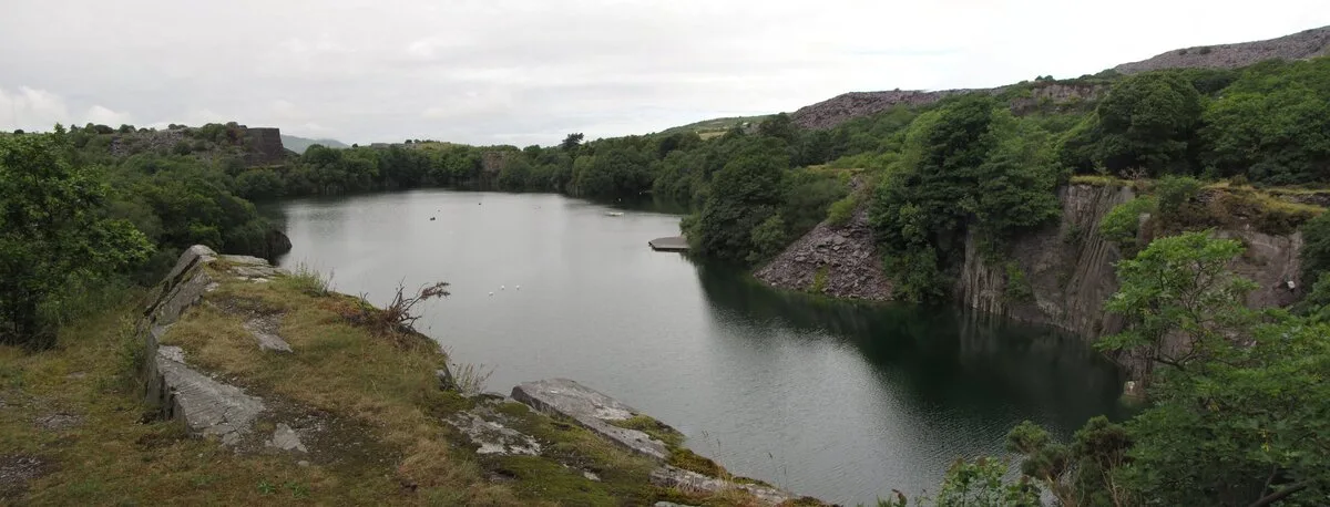
At Talysarn, in the Nantlle Valley in Gwynedd, the Dorothea Quarry is one of the most atmospheric abandoned places in Wales. Opened in the early 1820s and named Dorothea in the 1830s, it grew into the largest quarry in the valley, employing around 500 men at its 1872 peak and producing some 17,000 tons of slate a year. A Cornish beam pumping engine, the last new one ever built, drained the pits from 1904 until electric pumps took over in 1951.
The quarry closed in 1970 and was never redeveloped. The pumps stopped, and the deep pits filled with water to form the black lakes that define the site today, surrounded by ruined buildings, inclines and the Grade I listed engine house. The wider slate landscape of north-west Wales became a UNESCO World Heritage Site in 2021, but Dorothea itself remains an unrestored ruin. A warning: the flooded pits are extremely deep and cold, and have claimed many divers' lives, so admire the water, never enter it. More places on our Gwynedd urbex map.
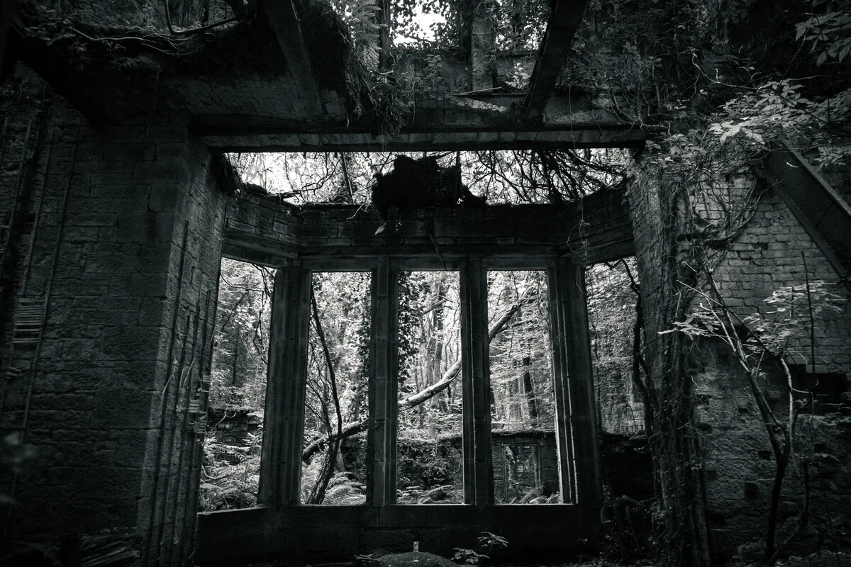
9. Hafodunos Hall: the fire-gutted Gothic mansion of Conwy
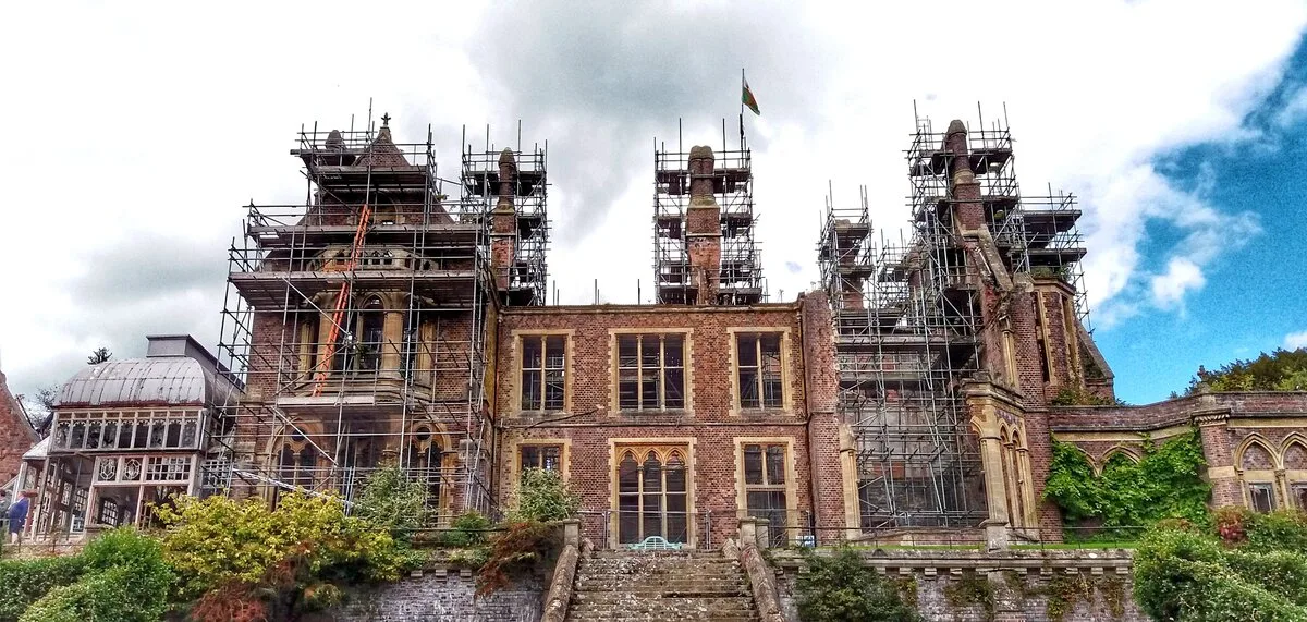
At Llangernyw, in Conwy, Hafodunos Hall is a Venetian Gothic Revival country house built between 1861 and 1866 by Sir George Gilbert Scott for the merchant Henry Robertson Sandbach, often called Scott's most important domestic work in Wales. The Sandbachs sold it in the 1930s, after which it served as a private girls' school and then a nursing home, which closed in 1993.
Left empty, the Grade I listed mansion was gutted by an arson fire in October 2004, an attack that caused some 8 million pounds of damage and led to two convictions. The main block has stood as a roofless, fire-blackened shell ever since, a favourite of Welsh urbex forums. It is privately owned and under a very slow restoration that, so far, has touched only the outbuildings, so the great hall itself remains a ruin in 2026. Private property, to be respected and viewed from a distance. See our Conwy urbex map.
10. Queensbury Tunnel: the abandoned railway tunnel of West Yorkshire
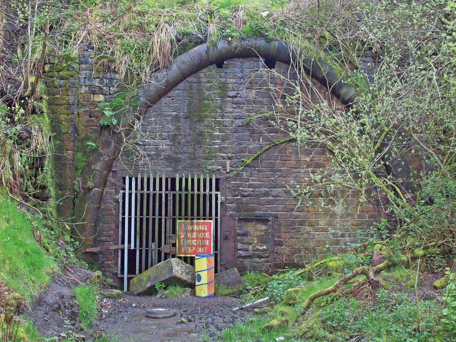
Between Halifax and Bradford, beneath the village of Queensbury in West Yorkshire, the Queensbury Tunnel is one of the most striking pieces of abandoned transport infrastructure in Britain. Built between 1874 and 1878 by the Great Northern Railway, it ran for 2,501 metres, the longest tunnel on the company's network when it opened, and its construction cost the lives of at least ten men.
The tunnel closed to all traffic on 28 May 1956 and has been disused ever since. Water ingress and two partial collapses, in 2013 and 2014, have left it dramatic and dangerous, knee-deep in water in places. National Highways has long sought to infill it, while the Queensbury Tunnel Society campaigns to reopen it as a cycle route, gathering more than 8,000 objections to abandonment; in July 2025 the government ordered safety works rather than closure. The tunnel remains intact, and flooded, for now. It is genuinely hazardous and largely sealed, so it is best understood from the portals rather than entered. More places on our Bradford urbex map.
FAQ - Urbex UK
How many abandoned places are there in the UK?
Thousands. Our map alone lists over 6,000 geolocated abandoned places across England, Scotland, Wales and Northern Ireland, from asylums and country houses to industrial sites, military land and deserted villages. This guide covers ten of the most iconic; the rest can be explored on the UK urbex map.
Is urban exploration legal in the UK?
Looking at and photographing buildings from public land is legal. Entering private property without permission is trespass, which in England and Wales is usually a civil matter rather than a crime, though it can become criminal damage or aggravated trespass, and military land like Imber is governed by by-laws with real penalties. We never encourage breaking in: explore from authorised access points, ask permission where you can, and force nothing.
Are these abandoned places dangerous?
Yes. Derelict buildings carry real risks: collapsing floors and roofs, asbestos, deep flooded pits like Dorothea Quarry, unstable tunnels like Queensbury, and live military ranges like Imber. Several of the sites here are best seen only from the outside. Go with someone, tell people where you are, carry a torch and a mask, and never enter a structure that looks unsafe.
Where can I find more free abandoned places near me?
Every spot in this guide has an "Add to my map" button that saves its GPS coordinates to your free personal map, with no credit card. To browse by area, use the regional maps linked under each entry, or start from the UK urbex map and zoom into your county.
When is the best time to explore abandoned places in the UK?
Spring and autumn give the best light and the least vegetation hiding the buildings, while winter strips the trees and suits ruins like Buchanan Castle. Some sites are seasonal by rule: Imber only opens to the public on a few set days a year, so always check access dates before travelling.
How do I contribute a spot to Urbex Maps?
Our community of more than 40,000 explorers adds and checks places continuously. Once you have a free account, you can submit a location with its coordinates and photos; a regional moderator then verifies that the place exists and is still standing before it goes live. That double-check is why our coordinates are reliable.
Conclusion: a kingdom of ruins
The United Kingdom abandons buildings the way few countries do, and for telling reasons: an industrial revolution that left mills, collieries and power stations behind; a Victorian asylum system that built vast hospitals later emptied by changes in care; aristocratic estates too costly to keep after two world wars and the taxes that followed; and, in Northern Ireland, the heavy architecture of a conflict that the country is still learning how to remember. From the concrete cathedral of St Peter's Seminary to the deserted street of Imber and the silent H-Blocks of the Maze, these ten places are a history of modern Britain told in ruins.
Explore them responsibly: most are private, listed or dangerous, and the point of urbex is to witness and record, never to damage or to break in. To discover everything else the four nations have to offer, browse the full UK urbex map and add your first free coordinates to your personal map.