The province of Utrecht looks too tidy for urbex, and that is exactly where the challenge lies. Between the brick walls of a collapsing listed farmhouse along the Vecht, the overgrown concrete shelters of the New Dutch Waterline on the Island of Schalkwijk, two forts slowly vanishing into the greenery, a drained psychiatric estate in the woods of Den Dolder and a derelict brickworks with its chimney on the Lek, lies a rich but fragile urbex territory. Our map counts more than 1,700 abandoned places in the Netherlands, with a dense cluster around the city of Utrecht, and we have drawn on that database. This article is the Utrecht deep dive of our big guide Urbex Netherlands: top 10 abandoned places.
In this guide you will find 6 abandoned places in and around Utrecht to discover in 2026: a derelict national-monument farmhouse, a field full of bricked-up water line bunkers, two overgrown forts of the New Dutch Waterline, the abandoned part of a psychiatric estate and a derelict brickworks. Each place has been individually checked: we have kept only the locations that are genuinely abandoned or derelict in 2026, still standing and not converted into a busy museum, hotel or housing development. Below each place there is a "Add to my map" button that saves the GPS coordinates to your personal account, free and without a credit card.
The search terms urbex Utrecht, abandoned places Utrecht, abandoned spots, urbex locations and urban exploration Utrecht all point to the same passion: finding, photographing and documenting buildings and structures that nobody uses any more and that nature is slowly reclaiming. Whether you are looking for an abandoned factory along the river, an abandoned fort in the water line, a derelict farmhouse in the city or an empty estate in the woods: these six places cover the whole province of Utrecht, from the Vecht to the Lek.
Discover hundreds of abandoned places in the province of Utrecht on the interactive urbex map →
Urbex Utrecht for free: why Urbex Maps makes the difference
Most lists of "abandoned places in Utrecht" promise free coordinates in the title, and then send you on to a private Facebook group, a forum or a paywall. We do it the other way round. Below each of the six places that follow you will find a real spot from our database, with a button that puts the GPS coordinates into your profile for free. No subscription, no credit card, no hidden conditions.
Behind that promise sits a verification model. A community of more than 40,000 urbexers has been mapping abandoned places since 2021, and every set of coordinates is checked at least twice: once by the person who submits the spot, and once by a regional moderation team that confirms the place still exists. The spots in this guide come from that database; the rest, hundreds of other Utrecht locations and over 1,700 across the Netherlands, is accessible through themed packs that fund the moderation work.
An honest warning first: almost all the places below are private land, protected national monuments or fenced-off sites, and some forts are protected nature reserves with bats where you may only enter by appointment. Urbex does not mean breaking in: you look, you photograph from permitted spots and walking routes, you force nothing and you damage nothing. Several places on this list are moreover genuinely dangerous or about to be redeveloped, so always check the current situation before you go.
What is NOT on this list (and why)
Anyone who googles "abandoned places Utrecht" quickly runs into names that have long stopped being real urbex spots. Utrecht redevelops at breakneck speed, and after checking we have deliberately left these places out. The Cereol factory (the old Pastoe factory) in Oog in Al has been a community centre with a library since 2014, and the neighbouring Werkspoorkathedraal has been an events hall since 2016. Neither is abandoned any more. The famous Fort bij Vechten near Bunnik is the paid Waterline Museum (UNESCO World Heritage), not an abandoned fort.
The same goes for other big names. Soesterberg Air Base is a managed nature and heritage park with a military museum, not a freely accessible ruin. Fort Honswijk in Schalkwijk was restored between 2020 and 2023 and is now rented out as a wedding and events venue. The city's water towers have been converted into homes, and castles such as De Haar and Huis Doorn are inhabited or museums. A place only earns a spot on this list if it is genuinely abandoned or derelict in 2026, still standing and not turned into a busy museum, hotel or building project. That is what sets us apart from the copy-paste lists that have been recycling the same outdated names for years.
1. De Klop farmhouse: the derelict national monument on the Vecht
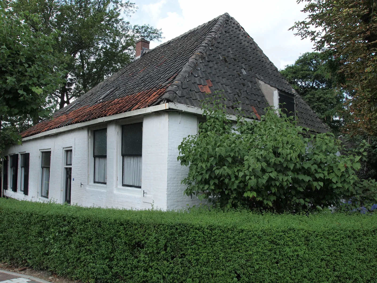
On the edge of Utrecht-Overvecht, where the Klopvaart flows into the Vecht next to Fort aan de Klop, stands the old De Klop farmhouse, the former inn-and-farm complex on the Klopdijk. The seventeenth-century house has been a national monument since 1993, but it has been in a sorry state ever since. The municipality of Utrecht sold the complex more than twenty years ago with a backlog of maintenance, on condition that the buyer would restore it; to this day that has never happened.
The result is a derelict monument in the middle of the city. In the spring of 2025, squatters moved into the building to stop the decay, but the Public Prosecution Service had them leave after a structural report found an acute risk of collapse. GroenLinks Utrecht repeatedly raised questions about the "deplorable state" and eventually forced the owner into a restoration plan. For now the farmhouse is still standing, empty, leaning and overgrown: a genuinely abandoned national monument. Note: because of the collapse risk, this is very much a place to view from the public dike, not to enter. More places on our urbex map of the province of Utrecht.
2. Werk aan de Groeneweg: the field full of water line bunkers
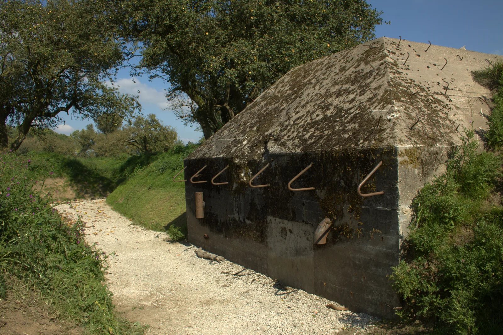
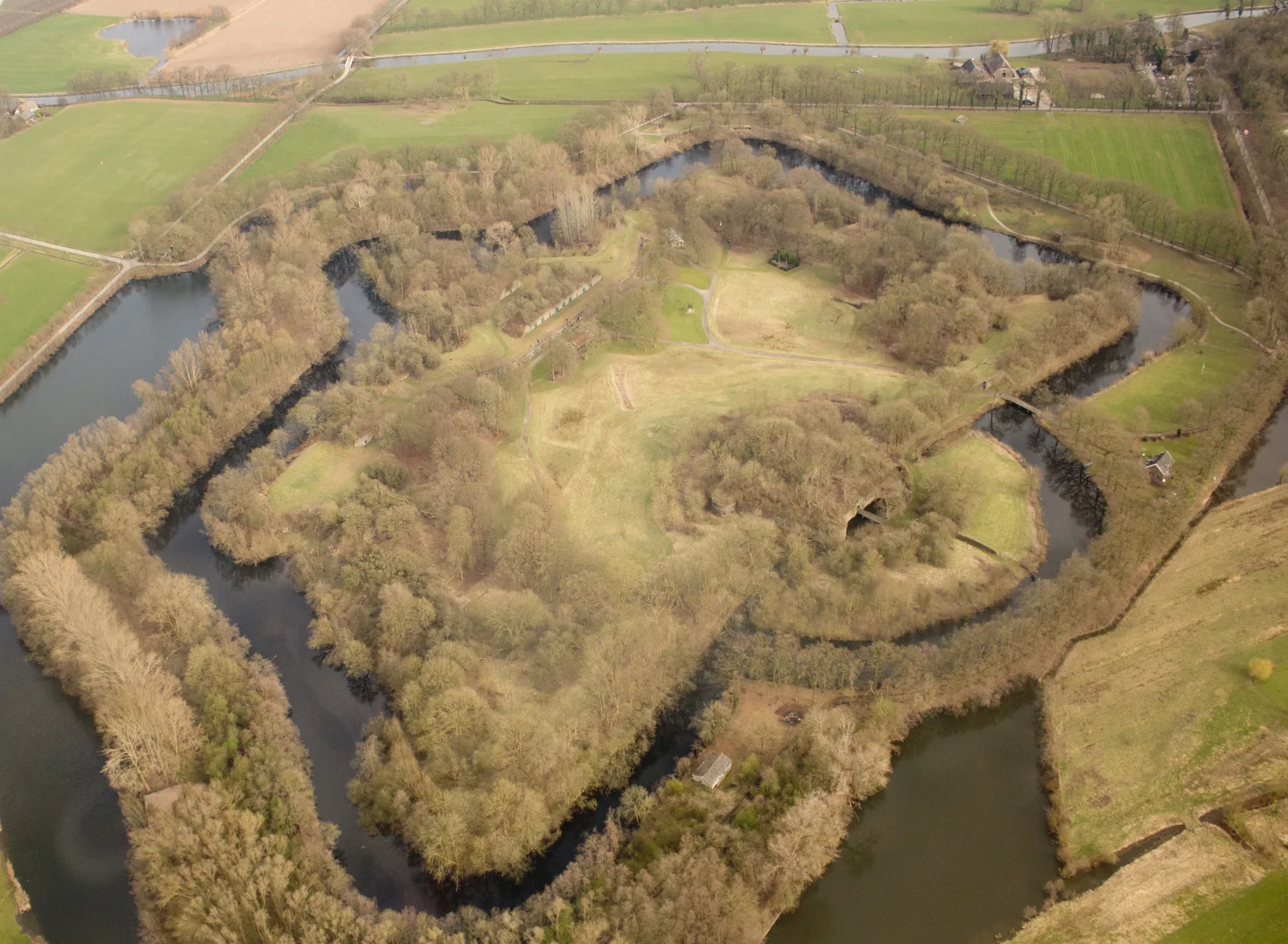
On the Island of Schalkwijk, along the Lek in the province of Utrecht, lies the Werk aan de Groeneweg, a strongpoint of the New Dutch Waterline built between 1914 and 1918 to cover Fort Honswijk. The infantry position consisted of a double trench with earthen ramparts and about 55 concrete group shelters. During the mobilisation of 1939-1940, tank barriers and pyramid-shaped bunkers were added.
After the capitulation of 1940 the Germans put the work out of use and bricked up the shelters. After that the site became overgrown. Owner Staatsbosbeheer restored it to its original state between 2013 and 2014, so you can now walk along the trenches and dozens of moss-covered concrete bunkers via a freely accessible discovery route, with the sky and the trees as the only roof. It is not a ticketed museum but a real open-air relic landscape, free to visit every day. The bunkers themselves are partly closed off and slippery; stay on the paths and do not crawl deep inside. One of the most photogenic water line spots in Utrecht. More places on our urbex map of the province of Utrecht.
3. Fort bij Tienhoven: the overgrown bat fort
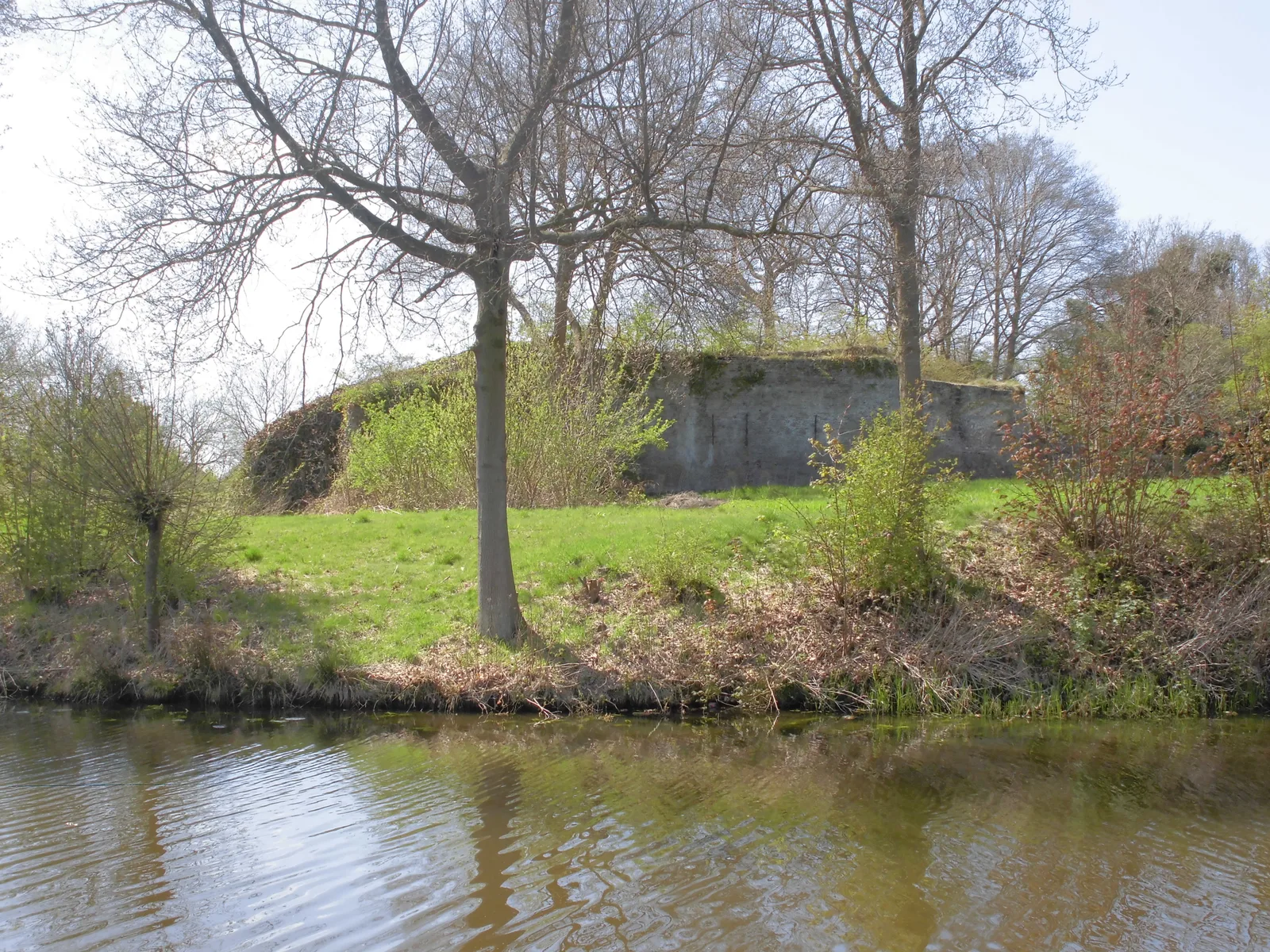
By the village of Tienhoven, north of the city of Utrecht, lies Fort bij Tienhoven, a small fort of the New Dutch Waterline from 1848-1850. Unlike most water line forts, which have become museums, care facilities or tea houses, this fort has been deliberately kept as a ruin. Since 1998 it has been owned by Staatsbosbeheer, which manages the site as a protected nature reserve and bat roost.
The result is an atmospheric, overgrown earthwork with a mossy brick wall behind the moat, lying abandoned and run wild for the walker. It is a national monument and part of the UNESCO World Heritage, but it is not freely accessible: you can only visit the inner grounds during occasional excursions, precisely to protect the hibernating bats. From the cycle path and the far side of the moat you get the finest, and legal, view of this forgotten fort. Do not push onto the site itself. More places on our urbex map of the province of Utrecht.
4. Willem Arntsz Hoeve: the drained psychiatric estate of Den Dolder
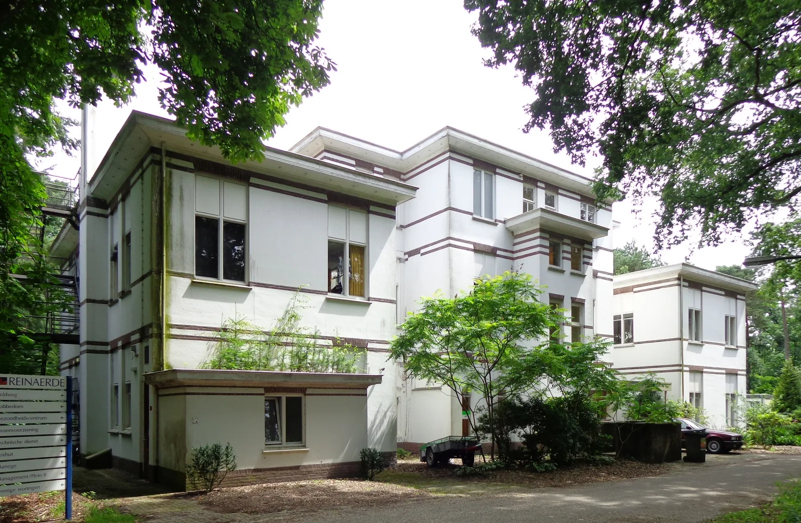
In the woods near Den Dolder, in the municipality of Zeist in the province of Utrecht, lies the Willem Arntsz Hoeve, a sprawling psychiatric estate founded between 1905 and 1911 by the Willem Arntsz Foundation. The monumental pavilions in Amsterdam School style, partly designed by architect Frans Poggenbeek, are national monuments. As psychiatry changed, the pavilions emptied out one by one.
Be honest in your expectations here: this is not a freely accessible ruin. The site has public walking paths, and parts of it are still in use as a secure forensic clinic (Fivoor) or are rented out temporarily. At the same time there are empty, neglected monumental buildings, awaiting the major "Bosch & Hei" redevelopment by developer BPD, which is turning the area into a housing district between 2025 and 2028. The departure of the clinics has been postponed to no later than 1 January 2027. So the window to see this charged, half-abandoned estate in its current state is closing fast. Photograph from the public paths and respect the secured and inhabited parts. More places on our urbex map of the province of Utrecht.
5. Fort bij Rijnauwen: the largest overgrown fort of the water line
Just outside Bunnik, east of the city of Utrecht, lies Fort bij Rijnauwen, by far the largest fort of the New Dutch Waterline. It was built around 1868-1870 and is a sprawling island of earthen ramparts, brick buildings and moats. During the Second World War the occupiers used the fort as an execution ground: a dark chapter that gives the site its heavy atmosphere.
Today the fort is managed by Staatsbosbeheer as a nature reserve and bat roost, and it is UNESCO World Heritage. The bomb-proof brick buildings are slowly disappearing under ivy and young trees, which gives the fort its abandoned, fairy-tale look. Important to know: this is not a place for free, casual exploration. The site is only accessible via guided tours (usually April to October, by registration), to protect the fragile nature and the hibernating bats. So book a tour or admire it from the outside along the Kromme Rijn; do not enter it on your own. More places on our urbex map of the province of Utrecht.
6. De Roodvoet brickworks: the derelict factory on the Lek
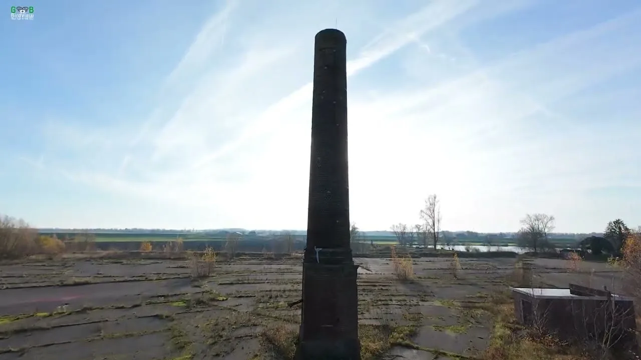
In the floodplains of the Lek, right across from Wijk bij Duurstede near Rijswijk, stands the abandoned De Roodvoet brickworks, a Wienerberger brick factory with a long history. The factory baked bricks for more than 126 years, with output rising to tens of millions of bricks a year and exports to Germany and England, until it closed its doors for good in 2008 because of the construction crisis.
Since then the complex has been falling into decay: long brick halls, collapsed roofs and the striking tall chimney rising above the floodplains. The site became a beloved urbex place, with even illegal raves that the owner was still complaining about to Omroep Gelderland in April 2025. Plans for a residential and recreation park ("Roodvoet wooneiland") are ready, with works possibly starting around the end of 2026, so the window is closing. Note: this is private land with active surveillance and enforcement, and it is dilapidated and dangerous. So view the chimney and the halls from a distance, or experience the place through photo and video. A freely licensed photo is lacking; the image above is a credited still from a drone video, with attribution. More places on our urbex map of the province of Utrecht.
FAQ - Urbex Utrecht
How many abandoned places are there in and around Utrecht?
Hundreds. Our map counts a dense cluster of abandoned places in the province of Utrecht, part of the over 1,700 across the Netherlands: derelict farmhouses, water line forts and bunkers, drained estates and industrial ruins. This guide covers six of the most striking; the rest you discover on the urbex map of the province of Utrecht or in our national guide Urbex Netherlands.
Is urbex legal in Utrecht?
Looking and photographing from the public road or a free walking route is allowed. Entering private land or a building without permission is trespassing, and depending on the situation can be punishable (vandalism, burglary). Some places on this list, such as Fort bij Rijnauwen and Fort bij Tienhoven, are moreover protected nature reserves with bats, where you may only enter by appointment. We never encourage breaking in: you explore from permitted spots, you book a guided tour where you can, and you force nothing.
Are these abandoned places dangerous?
Yes. De Klop farmhouse is at acute risk of collapse, De Roodvoet brickworks has collapsed roofs and loose stones, and the bunkers and bomb-proof buildings at the water line spots are dark and slippery. Many places on this list are better viewed from the outside. Never go alone, let your loved ones know where you are, bring a lamp, and never enter a structure that looks unstable. The forts are also protected: only enter them via a guided tour.
Where can I find more free urbex spots near me?
Each place in this guide has an "Add to my map" button that saves the GPS coordinates for free to your personal map, without a credit card. To search by area, use the province map below each place, or start at the urbex map of the Netherlands and zoom in on the province of Utrecht.
What is the best season for urbex in Utrecht?
Spring and autumn give the finest light and the least vegetation hiding buildings from view, while winter strips the trees bare and makes ruins such as Fort bij Rijnauwen or De Klop farmhouse more visible. The forts with bats are precisely closed in winter for the hibernating animals. Always check access beforehand: several places on this list are about to be restored, redeveloped or sold.
How do I submit a spot to Urbex Maps?
Our community of more than 40,000 urbexers constantly adds places and checks them. Once you have a free account, you can submit a place with coordinates and photos; a regional moderator then checks whether the place exists and is still standing before it goes online. That double check is what makes our coordinates reliable.
Conclusion: Utrecht, a fragile urbex landscape
Utrecht is a province that picks up its vacancy fast: factories become community centres, forts become wedding venues, water towers become apartments. That is precisely why the places that still stand genuinely abandoned or derelict are all the more precious. From a collapsing listed farmhouse on the Vecht and a field full of bricked-up water line bunkers, via two forts vanishing into the greenery and a drained psychiatric estate, to a brickworks with its chimney on the Lek: together these six places tell the story of Utrecht's heritage still poised on the threshold of change.
Explore them with respect: almost all the places are private, protected or dangerous, and the point of urbex is to witness and document, never to damage or break in. To discover everything the province has to offer, search the urbex map of Utrecht, read on in our national guide Urbex Netherlands, and add your first free coordinates to your personal map.