Urbex in Saint-Etienne has a distinctive face: a basin born of coal, steel and textiles, then hit by one of the most brutal industrial conversions in France. The direct consequence for the explorer is that most of the city's big wastelands have been demolished, decontaminated or redeveloped - the Ondaine basin and the Gier valley have become permanent building sites. The genuine abandoned places are therefore found less in the heart of the city than in its hinterland, towards the Loire and the neighbouring Haute-Loire. On our map, thousands of geolocated spots cover the whole Auvergne-Rhone-Alpes region.
For this article we picked 4 places that are genuinely abandoned and still standing in 2026, each verified one by one: a paper mill linked to the Lumiere brothers, France's very first railway tunnel, a listed mine pithead, and a ruined Romanesque chapel. No demolished spots, no renovated site passed off as a ruin, no museum dressed up as an adventure. Under each entry, an "Add to my map" button saves the GPS coordinates to your personal account, for free and with no credit card.
The queries urbex Saint-Etienne, Saint-Etienne urbex map, abandoned places Saint-Etienne, urbex spot Loire, urbex around Saint-Etienne and urban exploration Saint-Etienne basin all point to the same reality: an industrial and religious heritage that history set aside - the end of coal, textile bankruptcies, rural exodus, health laws - and that photographers, urbexers and historians are rediscovering today. This guide gives you each site's dated history, its legal status and its real dangers, before handing you its coordinates.
Free Saint-Etienne urbex: why Urbex Maps changes the game
Before the spots, a word on what makes this guide different. Most sites that talk about free urbex in Saint-Etienne put "free" in the title, then redirect you to a paid forum or a closed Telegram group - when they are not reselling you anonymised, recycled or already demolished spots. Here the promise is concrete: under each place, an "Add to my map" button sends the GPS coordinates to your personal account, with no subscription and no credit card.
Behind the map is a community of more than 40,000 explorers, active since 2021. Every coordinate is checked at least twice - by the contributor who submits it, then by a regional moderator who confirms the spot still exists and has not been walled up or razed. In a basin where wastelands fall one after another, that verification makes all the difference. The places offered in this article are part of that catalogue; the rest of the thousands of French spots are unlocked through packs that fund the moderation and field verification.
One reminder before you set off: urbex is not illegal in itself, but entering private property without permission is trespassing (article 226-4 of the French Penal Code, up to one year in prison and a 15,000 euro fine). We document these places for their history; we never encourage breaking in. Helmet, torch, ankle boots and caution on the floors: most of the spots below carry real collapse risks, and one of them is even subject to a municipal access ban.
1. Pont-de-Lignon paper mill - the Lumiere brothers' factory (Monistrol-sur-Loire)
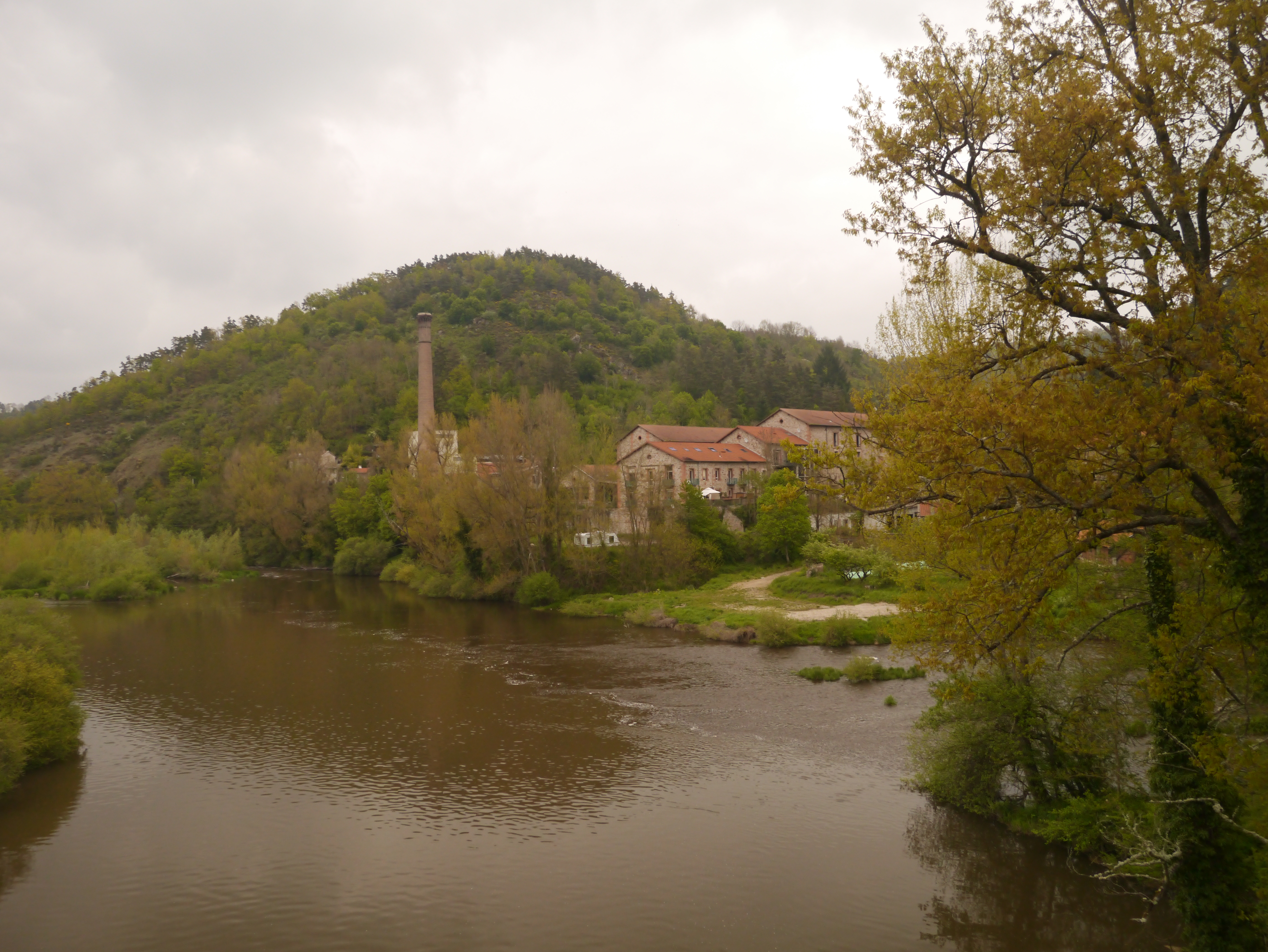
About twenty kilometres south-west of Saint-Etienne, on the bank of the Lignon at Monistrol-sur-Loire (Haute-Loire), stand the ruins of a paper mill linked to the Lumiere brothers. Built in 1895 and developed by the Lumieres to exploit the exceptional purity of the Lignon's water, the factory produced the base for photographic papers; after the war it was still making the famous blue paper of cigarette packets. Bought by Hachette in 1926, it closed in 1992. Since then its thousands of square metres have been falling into ruin, the roofs collapsing one by one.
This is the most solid "genuine abandoned wasteland" in the Saint-Etienne area: large, visible from the river, regularly squatted. Owned by a company in judicial liquidation unable to maintain it, the site has been subject to a municipal access ban since October 2023. Pollution and future-use studies are under way (green fund, ADEME); as of 5 June 2025, the local press confirmed that no demolition works had started - only studies.
Be honest with yourself about this place: it is formally off-limits, dangerous (collapsed floors and roofs), and its future is uncertain - demolition could be decided at any time. We give it to you for its history and because it is still standing, not to invite you to step over a municipal order. To be documented from the outside, from the bank of the Lignon, with full respect for the barriers.
The Pont-de-Lignon paper mill remains the most iconic industrial wasteland south of Saint-Etienne: a piece of the history of French photography left out in the rain.
2. Couzon tunnel - France's first railway tunnel (Rive-de-Gier)

About twenty kilometres north-east of Saint-Etienne, in Rive-de-Gier (Loire), hides a relic of the birth of the railway: the old Couzon tunnel, France's very first railway tunnel. Bored from 1826 to 1832 by the Seguin brothers on the pioneering Saint-Etienne-Lyon line - the first railway line on the continent - it entered service as early as 1830 to carry coal. 900 metres long, it was decommissioned in 1858 in favour of a parallel tunnel still in service today for current traffic.
The structure is standing, decommissioned and unconverted, which makes it a rare curiosity: a masonry tunnel from the very start of the railway era, abandoned for more than a century and a half. The gallery is partly blocked by a collapse and partially flooded. The site belongs to the SNCF on the Egarande side (closed) and to private owners on the Couzon side. A mark of its value: it has been listed as a Historic Monument since 2 May 1995.
Be aware that this is not a developed site: access is very restricted, closed on the SNCF side, and entering a collapsed, flooded gallery is extremely dangerous (rockfalls, drowning, total darkness, no ventilation at all). We present it as a major historical landmark in the area, to be approached at its portals, documented and respected - not as an underground exploration to attempt lightly. The reference address in the listing is 10 chemin Durozeil, on the Mont Durozeil side.
The Couzon tunnel is the most history-laden spot in the whole basin: here you literally touch the origins of the French railway.
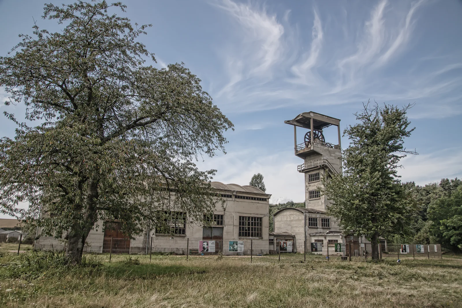
3. Puits des Combes - the forgotten pithead of the Ondaine (La Ricamarie)

Just 7 kilometres south-west of Saint-Etienne, on the northern slope of the Ondaine valley at La Ricamarie (Loire), stands the Puits des Combes, one of the last witnesses of Saint-Etienne coal. Its 29-metre prestressed-concrete headframe, of the Freyssinet-Limousin type, was completed in 1950; it still towers over the engine room and the workshops. Extraction stopped in 1972, water pumping continued until 1983. The site survived thanks to its isolation on the heights, then was bought by the town to escape destruction.
Unlike the famous Puits Couriot turned museum, the Puits des Combes has stayed raw: not demolished, not converted, not turned into a museum. It has been listed as a Historic Monument since 3 November 2003 and to date there is neither a museum nor organised visits on site. That is what makes it a precious spot for anyone seeking the real mining heritage of the Ondaine, far from the tourist trails.
Be clear-eyed about the nature of the place: it is more a protected heritage point of interest than a penetrable wasteland. The headframe and buildings are secured and the town watches over the site, so we give it to you to observe, photograph and understand the mine - not to force an entry. Standard risks of an old mining site if you get too close: weakened structures, shafts, scrap metal. Easily reached from the heights of La Ricamarie.
The Puits des Combes is the best entry point to understand, in the open air, what the Loire coalfield was before the museums.
4. Chapelle du Fraisse - the Romanesque chapel swallowed by the forest (Beauzac)

For anyone willing to drive some thirty kilometres south-west of Saint-Etienne, the Chapelle du Fraisse, at Beauzac (Haute-Loire), offers a completely different face of abandonment. This 12th-century Romanesque chapel, the remnant of a former priory, stands in the Ramel valley, above the gorges of the Loire. Worship was abandoned in 1817; since then it has let itself be overrun by vegetation while still standing. About sixty metres away, the ruins of the hamlet and farm of Fraisse-Bas complete this forgotten-world setting.
The chapel has been listed as a Historic Monument since 22 June 1972. An honest caveat: this is not a secret spot - the site is known and waymarked on a hiking trail (PR383), which makes it easy to reach but also busy. It fits perfectly what we look for here: a disused religious building and an abandoned hamlet, not a chateau and not a museum, unlike the restored "tourist" ruins of the area.
A freely accessible place via the trail, but an old ruin: stay cautious near the walls and vaults, do not climb on the structures and damage nothing. This is exactly the kind of site you explore for its atmosphere and history, not for the challenge - and respect for the place is the rule here. Find every spot in the area on the Loire map.
FAQ - Urbex Saint-Etienne
Is urbex legal in Saint-Etienne?
Urban exploration is not illegal in itself, but entering private property without permission is trespassing (article 226-4 of the French Penal Code). Several spots in this article are private, and the Pont-de-Lignon paper mill has been subject to a municipal access ban since 2023: we document them for their history, without ever encouraging break-ins. For more, read our guide is urbex legal in France.
Why so few spots in Saint-Etienne itself?
Because the Saint-Etienne basin is one of the most aggressive industrial-conversion territories in France: most of the big wastelands (Novacieries, Akers, Duralex, Jurine) have been demolished or redeveloped, and the Puits Couriot has become a museum. The genuine places still abandoned and standing are therefore found in the hinterland, towards the Loire and the Haute-Loire. That is our approach: widen the radius rather than sell you renovated or demolished sites.
Do I need special gear for these spots?
For the Pont-de-Lignon paper mill, ankle boots, a helmet and absolute caution around the collapsed roofs (and respect for the access ban). The Couzon tunnel is to be approached only at its portals - do not enter a collapsed, flooded gallery. For the Puits des Combes and the Chapelle du Fraisse, both accessible above ground, a good pair of shoes is enough. Our urbex gear guide covers the essentials to start safely.
Where can I find other abandoned places around Saint-Etienne?
Our map lists thousands of spots across the whole Loire department and neighbouring departments (Haute-Loire, Rhone, Ardeche). You can add the four places in this article to your personal map for free via the button under each entry, then unlock the rest through our regional packs.
Conclusion: Saint-Etienne, a city to explore through its hinterland
From the Lignon to the gorges of the Loire, Saint-Etienne urbex tells two centuries of industrial and working-class history: the adventure of the Lumiere brothers' photographic paper, the birth of the railway, the saga of Ondaine coal, and the medieval faith of a forgotten chapel. In a basin where everything is demolished fast, these four still-standing places are open-air history books, fragile, to be explored with respect and without damage. Add them to your map, and carry on your exploration with our Lyon urbex guide, our top 10 abandoned places in Auvergne or the free urbex map.