Madrid has an abandoned side far from the Gran Via: Civil War bunkers right in the middle of the Casa de Campo, a ruined mountain sanatorium, an old sugar refinery with its chimney, and even a ghost village from the Franco-era colonization. Our map gathers hundreds of abandoned places in the Comunidad de Madrid, and these four come from it.
We picked 4 abandoned places in Madrid for 2026, all verified and still standing. Under each entry, an "Add to my map" button saves the GPS coordinates to your account, free and with no card. Searches for abandoned places Madrid, abandoned sites Madrid and urbex Madrid lead right here. Discover all the abandoned places in Madrid on the urbex map →
Urbex Madrid for free: why Urbex Maps changes the rules
Most lists end up in a closed group where the coordinates are handed out "through contacts". We put an "Add to my map" button under each place that saves the GPS point to your account, free and with no card, in your personal space. Behind it is a community of more than 40,000 explorers since 2021, and every coordinate is checked at least twice. The free spots are free; the paid packs fund the moderation.
Why some places are not on this list
Let's be honest: many of Madrid's famous "ghost places" are no longer ghosts. The El Aguila brewery is now the Regional Library, the Nave Boetticher an innovation hub, and the Chamberi station a museum (Anden 0). The Algodor station, another abandoned gem of the region, is in our national guide to abandoned places in Spain. Here we only keep what is still genuinely abandoned in 2026.
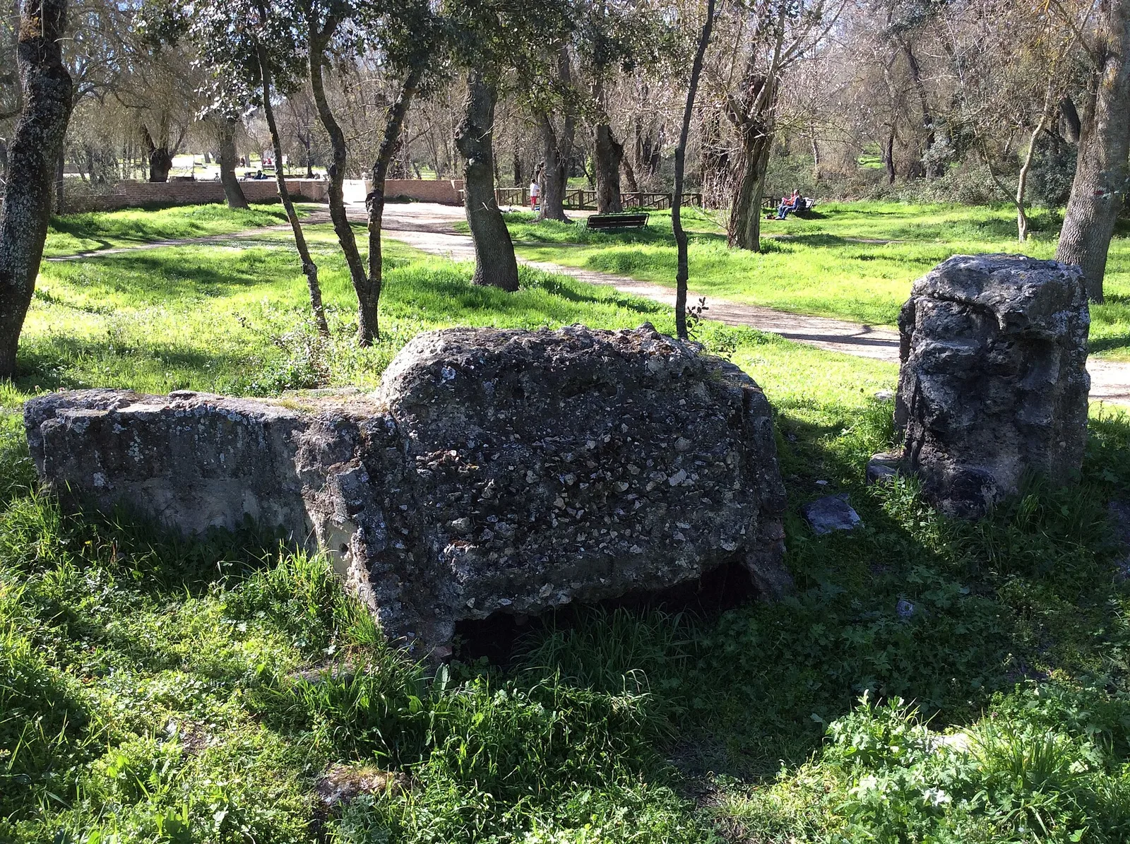
1. Casa de Campo bunkers: the Civil War beneath the park

Right in the Casa de Campo, the big park west of Madrid, bunkers, machine-gun nests and Civil War trenches survive. The Casa de Campo was the front line during the Battle of Madrid in November 1936, and Cerro Garabitas (677 m), its highest point, served as an artillery observation post for the rebels, who shelled the city center from December 1936.
Today, half-buried hexagonal concrete bunkers remain, in a freely accessible public park, neither fenced off nor turned into a museum. It is Madrid's most accessible historical urbex spot, ideal to start with. More places on our Madrid urbex map.
2. Sanatorio de la Marina (Los Molinos): the giant of the sierra
In Los Molinos, deep in the Sierra de Guadarrama (Comunidad de Madrid), the Sanatorio de la Marina stands in ruins, also known as the "Los Molinos Sanatorium". It was built by the Military Construction Service to a design by architect Pedro Muguruza (creator of the Valley of the Fallen), as an anti-tuberculosis sanatorium at over 1,200 m of altitude; it took in its first patients in the spring of 1949.
It later became a Navy pulmonary clinic and residence, until its final closure in 2002. It has been abandoned for more than twenty years: a seven-story V-shaped building, the interiors full of rubble, graffiti and the remains of bonfires. It belongs to the Ministry of Defence, which planned to auction it off. More places on our Madrid urbex map.
3. Azucarera de Aranjuez: the sugar chimney
Next to Aranjuez, on the banks of the Tagus, the old Azucarera de Aranjuez survives, the last trace of the sugar industry in the region. Its brick chimney, about 60 m tall, bears the date 1898; it was operated by the Sociedad General Azucarera de Espana from 1904 over some 60,000 m².
The last campaign was in 1982 and it closed for good in 1985. Since then it has been an industrial ruin with no public access, its future still being debated at the town hall (June 2025 plenary session). More places on our Madrid urbex map.
4. El Alamin: a ghost village of the colonization
In the municipality of Villa del Prado, southwest of the Comunidad de Madrid, lies El Alamin, an abandoned colonization village. It was founded in 1957 by the Marquis of Comillas to house the day laborers of his agricultural estate, with a grid-based Franco-era urban plan: houses, a church, a school and a square with a fountain, for around 150 inhabitants.
In the late 1990s the last residents left for Villa del Prado and Madrid, and the village was depopulated around the year 2000. Today it is a cluster of ruined houses and empty streets, with a reputation as a "haunted village" and very popular among urbex explorers. More places on our Madrid urbex map.
FAQ - Urbex Madrid
How many abandoned places are there in Madrid?
On our urbex map of the Comunidad de Madrid you'll find hundreds of verified points: sanatoriums, factories, colonization villages, Civil War bunkers and stations.
Is urbex legal in Madrid?
Exploring is not a crime, but entering private or fenced-off property can be trespassing. The Casa de Campo bunkers are in a freely accessible public park; the sanatorium and the sugar refinery are private or military property. Respect the bans and don't damage anything.
Are these places dangerous?
Yes. The Los Molinos sanatorium has collapsed floors and lift shafts, and the sugar refinery and El Alamin have unstable walls. Don't explore alone, bring a flashlight and a charged phone, and don't step on damaged floors.
Which abandoned village can you visit near Madrid?
El Alamin (Villa del Prado) is the best-known ghost village in the region, depopulated around the year 2000. It is private property and in ruins, so visit it with respect and caution.
Where to find more abandoned places in Madrid?
On our free urbex map and on the Madrid map there are hundreds of points. Under each free point, click "Add to my map" to save the GPS coordinates to your account.
Conclusion: the Madrid that's not in the guidebooks
Behind the tourist Madrid there are Civil War trenches, mountain sanatoriums, sugar factories and emptied colonization villages. These four places are only the beginning. Explore responsibly: respect the bans, don't step on floors that might give way, and leave no trace. To discover more, head to our Madrid urbex map and save your coordinates for free on your personal map.