
No city in the Netherlands hides as much space under and around its streets as Maastricht. Beneath the Sint-Pietersberg lie tens of kilometres of abandoned marl quarries, in the rolling hills crumbling monasteries stand between thuja hedges, and just across the Belgian border an empty cinema and the cemetery of a psychiatric hospital are slowly rotting away. This is perhaps the richest urbex area in the country. For Limburg alone our map counts more than 170 geolocated abandoned places, and we drew on that database.
In this guide we have selected 6 abandoned places in and around Maastricht to discover in 2026: an underground marl quarry, an abandoned Jesuit monastery, an empty cinema, the cemetery of an old asylum, a forgotten Michelin-starred restaurant, and the marl labyrinth beneath the mountain. Each place has been individually verified: we kept only places that are genuinely abandoned, still standing, and that have not been turned into a museum, hotel or housing by the summer of 2026. Below each place, an "Add to my map" button drops the GPS coordinates into your profile for free, with no credit card.
The search terms urbex Maastricht, abandoned places Maastricht, abandoned places Limburg, urbex Limburg and abandoned places South Limburg all point to the same passion: finding, photographing and documenting buildings and caves that nobody uses any more and that time is slowly reclaiming. Whether you are looking for an abandoned marl quarry, a crumbling monastery, an empty cinema or an abandoned hospital, this list covers both the Dutch and the Belgian side of South Limburg, a stone's throw from the city.
Discover thousands of abandoned places across Limburg on the interactive urbex map →
This guide is the urban sequel to our big national guide. If you want to see the whole country, start with our pillar on the ten best abandoned places in the Netherlands, which includes, among others, the ENCI quarry on the edge of Maastricht. Below we go deeper with six other places, all within half an hour's drive of the Markt.
Urbex Maastricht for free: why Urbex Maps makes the difference
Most "abandoned places in Limburg" lists promise free coordinates in the title, then funnel you off to a private Facebook group, a forum or a paywall. We do the opposite. Beneath each of the six places that follow you will find a real spot from our database, with a button that drops the GPS coordinates into your profile for free. No subscription, no credit card, no hidden conditions.
Behind that promise sits a verification model. A community of more than 40,000 explorers has been mapping places since 2021, and every set of coordinates is checked at least twice: once by the person who reports the spot, and once by a regional moderation team that confirms the place still exists. The spots in this guide come from that database; the rest, the thousands of other abandoned places in the Netherlands and Belgium, are accessible through thematic packs that fund the moderation work.
This list is ordered by visual impact and historical weight, not by distance. We open underground, in a centuries-old marl quarry, then move via an abandoned monastery and an empty cinema to a silent cemetery, a forgotten starred restaurant and the great gallery system beneath the mountain. Below each place there is a link to the map of the relevant province. And an honest warning: many of the places below are private property, protected heritage or dormant building projects. Urbex does not mean breaking in: you look, you photograph from permitted spots, you force nothing and you damage nothing.
What is NOT on this list (and why)
If you google "abandoned places Maastricht", you quickly run into names that are no longer a real urbex spot. We deliberately left them out, after checking. The Sphinx factory on the Bassin appears in every old list, but the site has been redeveloped for years into the buzzing Sphinx quarter with cinema, housing and restaurants, so it is no longer an abandoned place. The famous ENCI quarry and factory at the foot of the Sint-Pietersberg is genuinely abandoned, but we already covered it in detail in our pillar on the Netherlands, so we leave it out here to show you six new places instead.
The same goes for the casemates and Fort Sint-Pieter: spectacular, but these days safely visitable with a guide through Maastricht Underground, so heritage tourism rather than abandoned urbex. And the Tapijn barracks, a military site closed for decades, has been converted since 2010 into a campus of Maastricht University. A place only earns its spot on this list if it is genuinely abandoned in 2026, still standing and not redeveloped. That is what sets us apart from the copied lists that have been circulating the same outdated names for years.
1. Caestert quarry: the abandoned marl quarry beneath the mountain
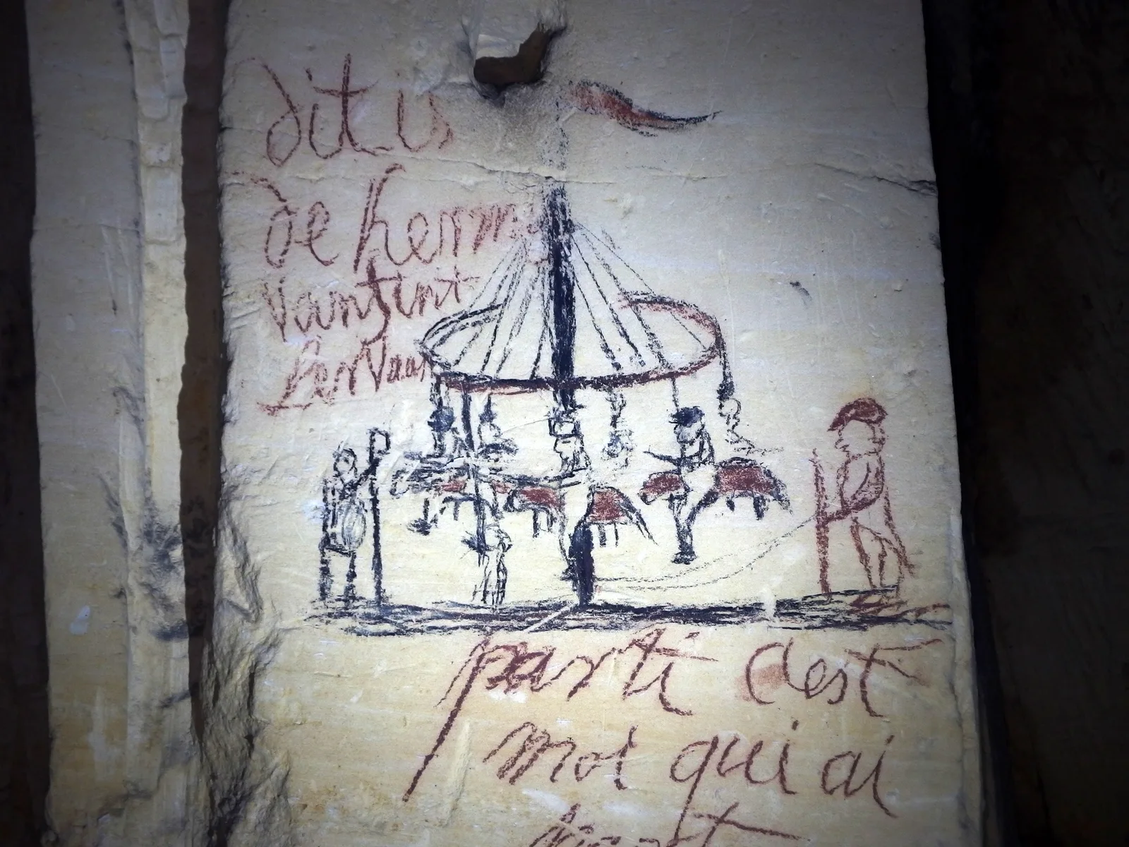
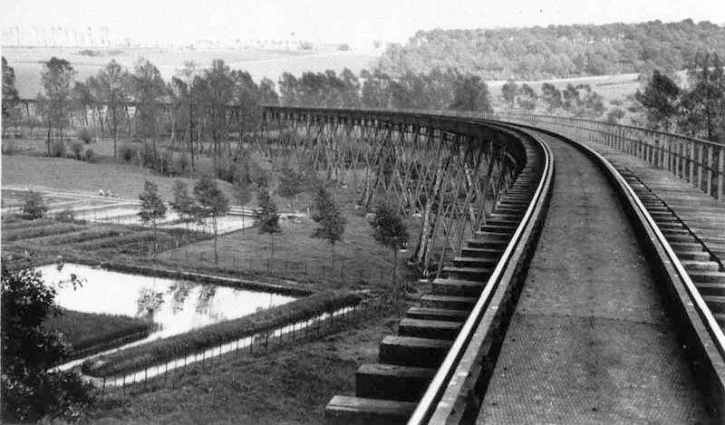
In the southern part of the Sint-Pietersberg, on the Caestert plateau between Maastricht and the Belgian village of Kanne, lies the Caestert quarry: an abandoned marl quarry of roughly 900 by 600 metres, with hundreds of galleries running off in every direction. Marl was hewn out here by hand from the Middle Ages onward to win blocks of building stone; around 1850 the work stopped and a maze of galleries was left behind.
The quarry is a logbook of history: on the soft walls are centuries-old charcoal drawings, inscriptions and names, and during the Second World War the Dutch-Belgian resistance smuggled people and goods through it. Later there was even a mushroom farm in the galleries. Since the 1970s the whole area has been a nature reserve and a hibernation site for bats, and the quarries are closed to the public for safety and nature reasons: the galleries can collapse and you get lost dangerously fast. This is a place to experience from above, from the walking paths over the mountain. More spots on our urbex map of Limburg.
2. Jesuit monastery Valkenburg: the abandoned college
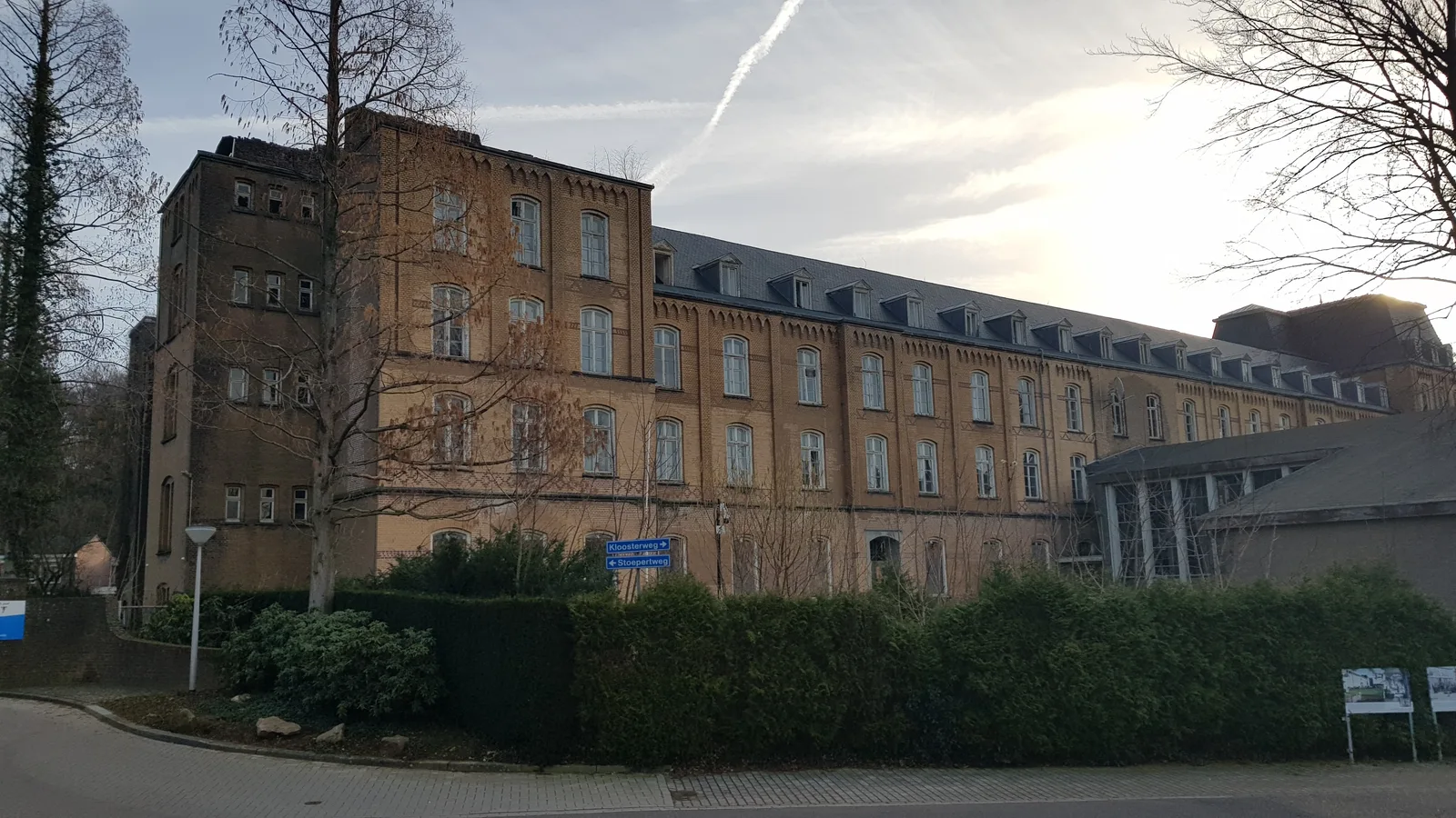
On the Kloosterweg in Valkenburg aan de Geul, hidden behind tall thuja hedges, stands the Jesuit monastery, one of the largest abandoned buildings in South Limburg. It was built between 1893 and 1895 by Jesuits driven out of Germany by the Kulturkampf, to a design by architect H.J. Hurth. This became the Ignatius College for German Jesuits; in 1911 a wing and a library were added, creating an imposing E-shaped complex with a neo-Gothic chapel and tower in the centre.
During the Second World War the Jesuits were driven out again, this time by the Gestapo, and in 1943 the occupiers blew up the chapel. After the war the Sisters of Saint Joseph bought the complex; they left in 1985 for a new building in the garden. Since then the old college has stood largely empty and is slowly falling into ruin, which made it one of the best-known urbex locations in the region. Note: the complex is private property and is nowadays guarded with cameras and an alarm; admire the facade from the public road. More places on our urbex map of Limburg.
3. Euroscoop Lanaken: the emptied cinema
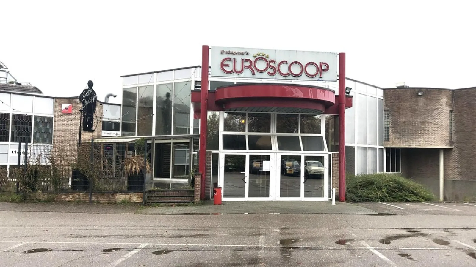
Just across the border, in Lanaken less than five kilometres from the centre of Maastricht, the large Euroscoop cinema complex with eight screens stands empty. Burdened by heavy losses, the Pathe group no longer wanted to invest in the cinema and closed it; since November 2024 the building has stood empty and was sold to a property developer from Hasselt.
In a short time the empty cinema grew into one of the best-known urbex hotspots in the region. In April 2025 the first images from urban explorers appeared online; in January 2026 explorers broke in through a broken window, after which a clip on TikTok was viewed more than 40,000 times, and in May 2026 eight urbexers were arrested inside the complex. The owner has since installed extra fencing and camera surveillance, and there are plans for a hotel with housing. In other words: it is private property, it is guarded and time is running out. View it from the outside and respect the fencing. More spots on our urbex map of Belgian Limburg.
4. The cemetery of the Rekem psychiatric hospital
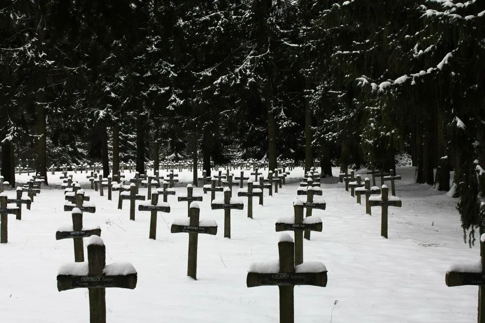
On the Daalbroekstraat in Oud-Rekem, a district of Lanaken right next to Maastricht, lies one of the most moving abandoned places in the area: the cemetery of the Rekem psychiatric hospital, known in urbex circles as the "cemetery of the mad". Between 1921 and 1981, about 1,750 patients were buried here, exclusively men, who no longer had any ties to their families.
The asylum was housed in the eighteenth-century Aspremont-Lynden castle in the old centre, which served as a state lunatic asylum from 1921. The wooded cemetery outside became overgrown after the closure; the simple wooden and concrete crosses sagged and weathered, which made it a fixture on urbex lists. In 2024 the podcast "Monsters in het Bos" devoted an episode to it. The place is quiet and fragile: respect the dead, stay on the paths and take nothing. More places on our urbex map of Belgian Limburg.
5. Truite d'Or, Gulpen: the forgotten Michelin-starred restaurant
In the green Geul valley near Gulpen, in the municipality of Gulpen-Wittem, stands a crumbling villa that urbex circles call "Villa Suicide", but which has a far richer history: this was Truite d'Or, once a Michelin-starred restaurant. The place started around 1898 as a trout farm of the Nederlandsche Heidemaatschappij; visitors could eat fresh trout by the fish ponds. From 1967 the restaurant was named Truite d'Or.
Under chefs Theo Kurvers and Karel Swart it earned a Michelin star in 1977, which it held until 1980. After that it went downhill: the restaurant closed, the building fell into disrepair and now stands abandoned among the old ponds and meadows. It is private property and isolated; the villa is fragile and the floors are unreliable. Look and photograph from the public road and the walking path, and do not enter the building. More spots on our urbex map of Limburg.
6. The marl labyrinth beneath the Sint-Pietersberg
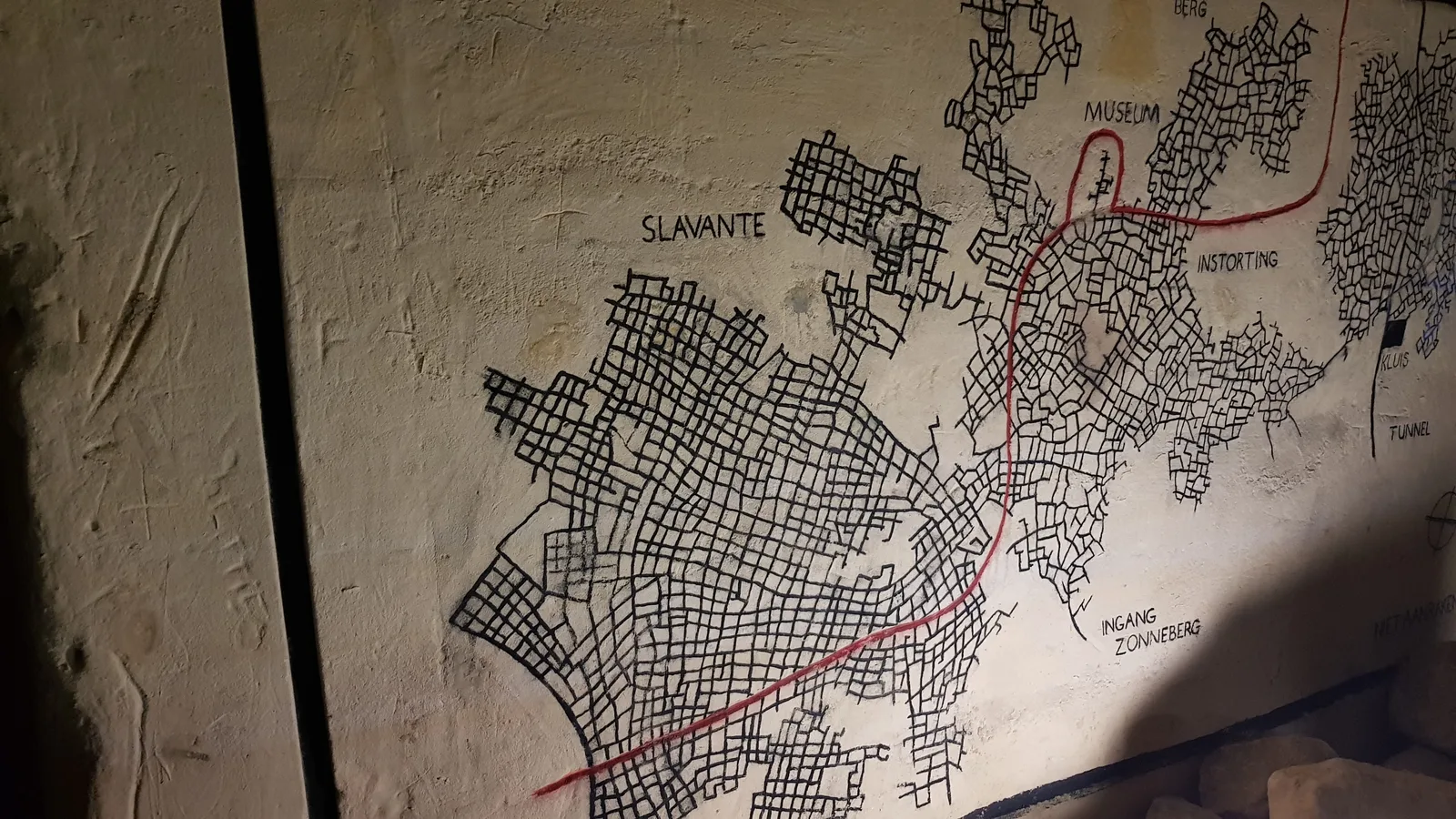
The Caestert quarry is only a fragment of a far larger whole. Beneath the Sint-Pietersberg and the neighbouring hills of South Limburg lies a marl labyrinth of tens of kilometres of galleries, created by centuries of block quarrying. These Limburg marl quarries together form the most extensive underground gallery system in the Netherlands, with names like Groeve de Keel, the Northern Gallery System and the system beneath the Cannerberg.
In the galleries you can read the history of the mountain: on the walls are floor plans, inscriptions, war drawings and even a complete underground "map" of the maze, so that quarry climbers could find their way. Some parts were used as a shelter during the war, others as a mushroom farm. The quarries, however, are life-threatening and largely closed: blocks fall down, you get lost without a guide, and in winter protected bats hibernate there. Anyone who wants to see it safely can visit part of it with an accredited guide; free exploration is not an option here. More places on our urbex map of Limburg.
FAQ - Urbex Maastricht
How many abandoned places are there in and around Maastricht?
Many. For the province of Limburg alone our map counts more than 170 geolocated abandoned places: marl quarries, monasteries, factories, churches and military works, plus hundreds more just across the border in Belgian Limburg. This guide covers six of the most striking places around Maastricht; you explore the rest on the urbex map of Limburg.
Is urbex legal in the Netherlands and Belgium?
Looking and photographing from the public road is allowed. Entering private property without permission is trespassing and can, depending on the circumstances, become a criminal offence (vandalism, breaking and entering). We never encourage breaking in: you explore from permitted spots, you ask for permission where possible and you force nothing. Several places on this list, such as the Jesuit monastery and the Euroscoop, are moreover guarded with cameras.
Are these abandoned places dangerous?
Yes. Abandoned buildings carry real risks: collapsing floors and roofs, asbestos and unstable structures like at Truite d'Or. The marl quarries are a category of their own: blocks fall down and you get lost dangerously fast in the dark. Several places on this list are therefore better viewed from the outside. Never go into the mountain alone, let people know where you are and do not enter any structure that looks unstable.
Where can I find more free urbex spots nearby?
Below each place in this guide is an "Add to my map" button that drops the GPS coordinates onto your personal map for free, with no credit card. If you want to search by area, use the linked province maps below each place, or start with the urbex map of Limburg and zoom in on your region.
What is the best season to explore in South Limburg?
Spring and autumn give the finest light and the least vegetation for the above-ground places such as the monastery and the Rekem cemetery. In winter the snow-covered cemetery looks even more striking, but then the marl quarries are extra vulnerable because of hibernating bats. Always check access before you set off: several places on this list are about to be sold or redeveloped.
How do I report a spot to Urbex Maps?
Our community of more than 40,000 explorers is constantly adding places and checking them. Once your free account is created, you can submit a place with coordinates and photos; a regional moderator then checks whether the place exists and is still standing before it goes online. That double check makes our coordinates reliable.
Conclusion: a city with a double bottom
Few places in the Netherlands have such a double bottom as Maastricht, and there is history behind it: centuries of marl extraction that left an underground maze, a border region full of monasteries and sanatoriums that grew too big to maintain, and an edge of Belgian Limburg where an old asylum and a bankrupt cinema are slowly disappearing. From the centuries-old drawings in the Caestert quarry to the silent cemetery of Rekem, these six places tell the story of a region that never quite clears up.
Explore them responsibly: most are private property, protected or downright dangerous, and the point of urbex is to witness and document, never to damage or break in. If you want to discover what else South Limburg and the rest of the country have to offer, search the urbex map of Limburg, read our pillar on abandoned places in the Netherlands and put your first free coordinates on your personal map.