Urbex in Liège tells the story of a fiery city that dug the deepest coal in the country, blew crystal and glass, raised blast furnaces along the Meuse, then watched entire swathes of its industry fade out. Between a deconsecrated neo-Gothic church in Flémalle, a colliery turned into a graveyard of rusty Fords, a noble castle left to the brambles near Verviers and a vast textile mill on the bank of the Vesdre, Liège and its basin form one of the densest urban exploration grounds in Wallonia. Our map lists thousands of geolocated spots across the province of Liège and the rest of Belgium.
In this guide, we have selected 6 places genuinely abandoned and still standing in 2026, each verified one by one: a church with a blue Christ, two collieries that bear witness to the Liège coal basin, a gutted neo-Gothic castle, the oldest manor of a spa town and a wool mill saved from demolition. No demolished monument presented as a living spot, no restored attraction disguised as a ruin. Under each entry, an "Add to my map" button saves the GPS coordinates to your personal account, free of charge and with no bank card.
The searches urbex Liège, urbex Liege, abandoned place Liège, abandoned places province of Liège and urban exploration Liège all point to the same reality: a mining, industrial and bourgeois heritage that History has set aside through the closing of collieries, parishes emptying out and steel wasteland, and that photographers, urbexers and historians are rediscovering today. This dossier gives you, for each site, its dated history, its legal status and its real dangers, before handing you its coordinates. It is the local complement to our ranking of abandoned places in Belgium.
Free urbex in Liège: why Urbex Maps changes the game
Before the spots, a word about what sets this guide apart. Most pages about abandoned places in Liège put "free" in their title, then send you off to a closed Facebook group, a forum or a paywall. Here the promise is concrete: under each place, an "Add to my map" button drops the GPS coordinates into your personal account, with no subscription and no bank card.
Behind the map hides a community of more than 40,000 explorers, active since 2021. Each set of coordinates is verified at least twice: once by the person who reports the spot, then once by a regional moderator who confirms that the place still exists and that it hasn't been walled up or demolished. The places featured in this article are part of this catalogue; the thousands of other Liège and Belgian spots are unlocked via packs that fund moderation and on-the-ground verification.
A reminder before you set off: urban exploration is not illegal in itself, but entering private property without permission constitutes trespassing, which can become an offence as soon as there is damage or someone ignores a fence or a sign. We document these places for their history; we never encourage breaking in. Helmet, headlamp, high-top shoes and caution on the floors: several of the spots below present real risks of collapse and asbestos, and the colliery shafts hide holes.
1. Saint-Jean-Baptiste Church: the church with the blue Christ (Flémalle)
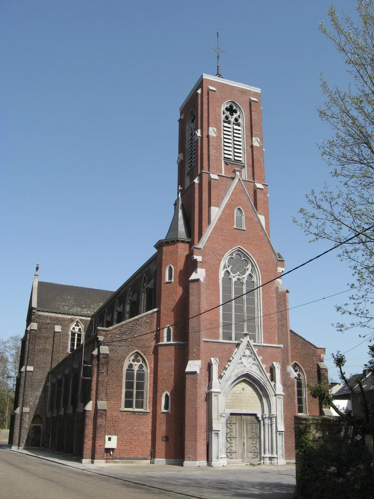
In Flémalle-Grande, west of Liège, the Saint-Jean-Baptiste Church is known to urbexers around the world under the name "Blue Christ Church". Built between 1878 and 1882 by the architect Eugène Halkin in a neo-Gothic style of brick and limestone, it was consecrated on 23 May 1882 to serve the parish in full mining boom. Its nave, its transept and its polygonal apse made it an imposing building.
Services stopped around 1990, as the building could no longer be maintained, and the church has been disused ever since. Its nickname comes from a large blue cross topped by a Christ that still dominates the choir, the most photographed image of the place. Plundered (its 1596 organ was vandalised and its pipes stolen in 2015), overrun by pigeons, it has undergone neither restoration nor demolition: the municipality only recommended sealing off the accesses. The building is a closed private property, whose doors are regularly resealed and then reopened. It is the most emblematic abandoned place of western Liège. More spots on our urbex map of the province of Liège.
2. Charbonnage du Renard: the graveyard of rusty Fords
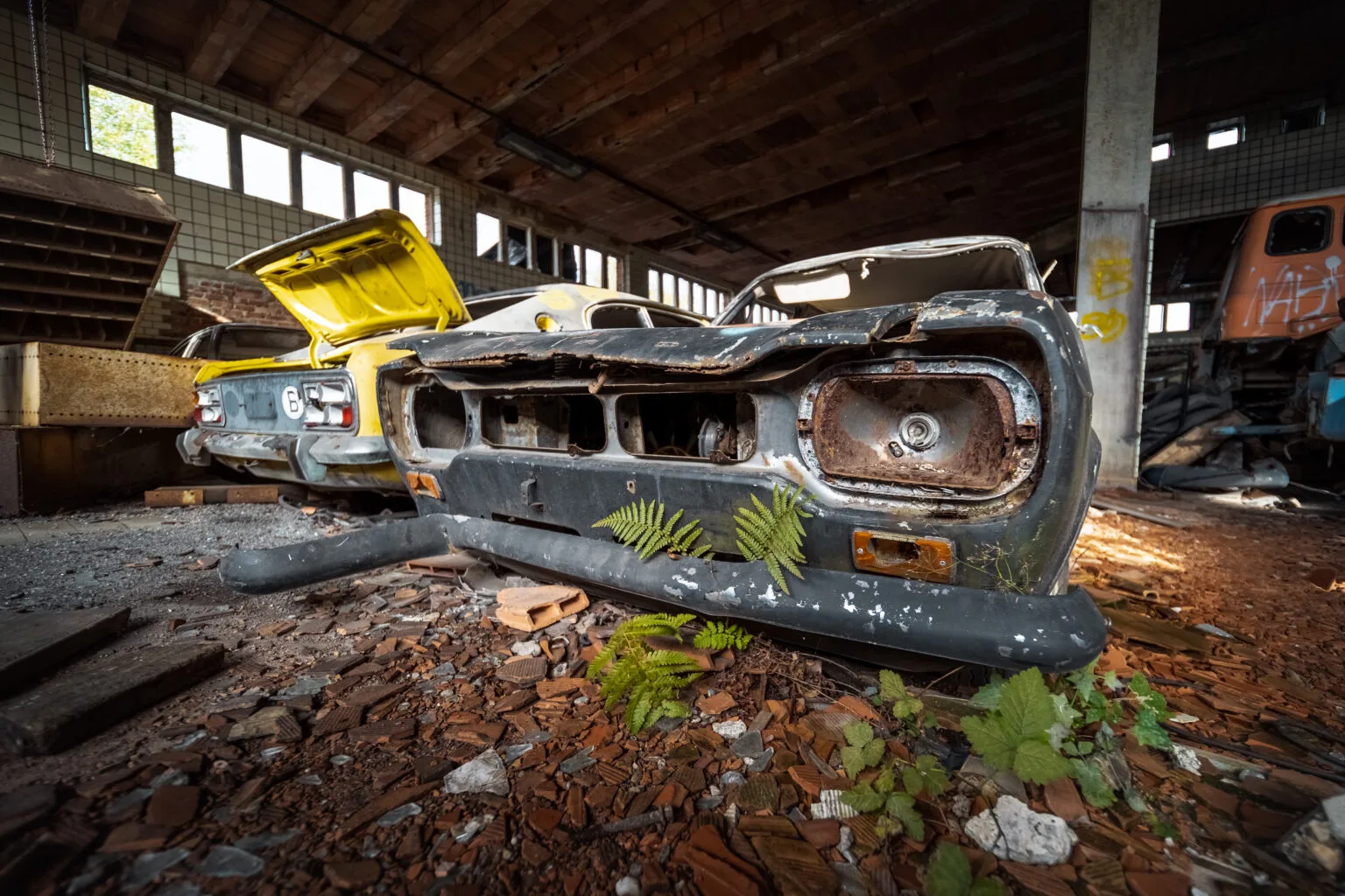
East of Liège, in the trail of the old collieries between Beyne-Heusay, Fléron and Romsée, the Charbonnage du Renard is one of the most singular urban exploration spots in the region. In 1937, the pithead still extracted 620,000 tonnes of coal and employed some 2,100 people, before closing towards the end of the 1960s. In 1972, the site was bought by a garage owner who turned it into a vehicle depot.
That is what makes its appeal: dozens of old cars, mostly Fords, sleep in the great hall and in the dark cellars, stacked against one another, gnawed by rust and vegetation. A project for around a hundred dwellings collapsed when soil analyses revealed heavy metal pollution (lead, mercury), which paradoxically saved the place from demolition. The site is a private property that the authorities are trying to secure, and its access closes off year after year: to be observed from the surroundings. More places on our urbex map of the province of Liège.
3. Charbonnage du Hasard at Micheroux: the deepest shaft in the basin
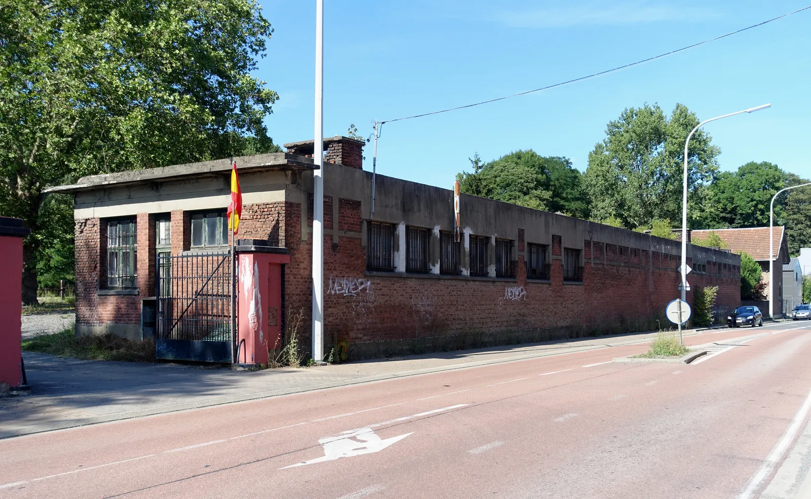
At Micheroux, in the municipality of Soumagne, east of Liège, the pithead of the Vieux Bure and the Grand Bure was one of the collieries of the Société anonyme des Charbonnages du Hasard, the same company as Cheratte but a quite distinct site. Its shafts descended to 913 metres, the deepest of the Liège coal basin. The Grand Bure ceased its activity in 1974, and the company was dissolved in 1977.
Since then, the brick buildings have been decaying above the galleries, covered in graffiti and ivy. The installations of shafts no. 1 and no. 4 have been listed since the 1980s, which protects them from outright demolition, but part of the annexes remains threatened: make the most of it while the whole site stands. The site is a private and dangerous property, riddled with shaft openings: it is admired from the outside. The Hasard of Micheroux tells, more discreetly than the great blast furnaces, the end of the Liège "Black Country". More spots on our urbex map of the province of Liège.
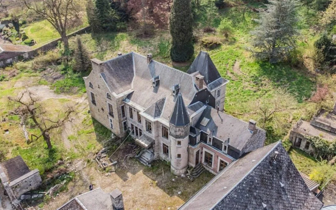
4. Château del Marmol: the "villa of the black cat" (Ensival)
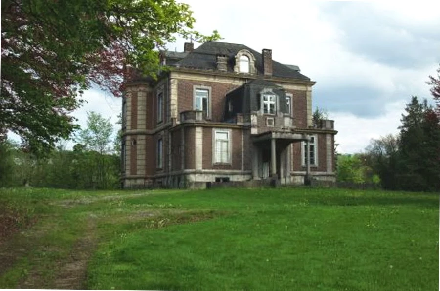
In Ensival, in the suburbs of Verviers, the Château del Marmol, better known to explorers under the name "villa of the black cat", is one of the rare castles genuinely abandoned and still standing in the region. Built around the middle of the 19th century by the del Marmol family, ennobled in Belgium in 1845, it was later inhabited by the wool industrialist Louis Zurstrassen-Renkin and surrounded by a two-hectare park with rare tree species.
Left empty for years, plundered and vandalised, it has kept remnants of its sumptuous rooms, frescoes and finely worked woodwork, which make it one of the most photographed abandoned interiors of the Pays de Verviers. No restoration has succeeded, and both the facade and the mansard roof still hold, caught in the vegetation. It is a private property to respect and to observe from the outside. More places on our urbex map of the province of Liège.
5. The Manoir des Thermes: the oldest house in Chaudfontaine
Along the avenue des Thermes, in Chaudfontaine, the Manoir des Thermes is probably the oldest house in the municipality: a large rear section dates back to the 16th century. This dwelling of the former mayors, enlarged from the 17th to the 20th century, has been abandoned for some twenty years and even survived the terrible floods of the Vesdre in July 2021.
Its fate was decided in court: a 2021 permit planned to demolish everything to build 28 dwellings, but a collective of local residents backed by the Communauté Historia obtained its annulment in view of the heritage interest of the property. A new real estate project, submitted to public inquiry in June 2026, this time preserves the manor and only demolishes its annexes. While awaiting the works, the old building remains abandoned: a fragile witness to the history of the spa town, to be photographed from the street. More spots on our urbex map of the province of Liège.
6. La Textile de Pepinster: the wool mill on borrowed time
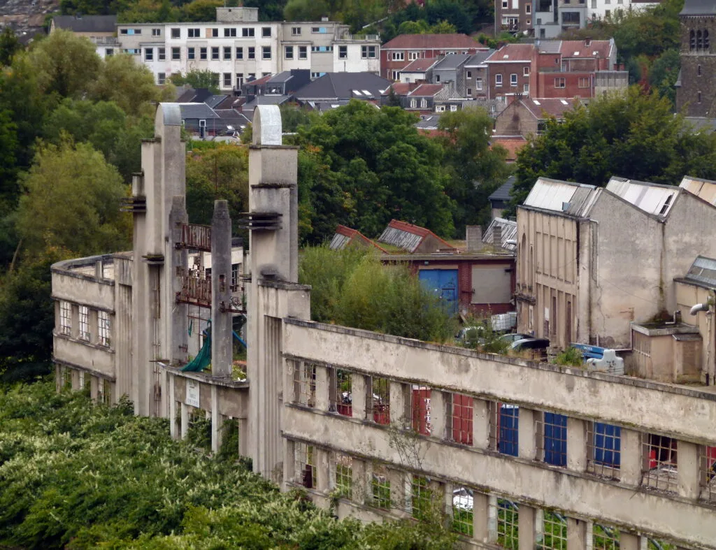
In Pepinster, at the confluence of the Vesdre and the Hoëgne, the old textile mill known as Texter (the "S.A. La Textile de Pepinster") stretches its monumental facade above the river. The site, heir to a cloth workshop from the early 19th century, took on around 1862 the appearance the people of Pepinster would know it by until the end, with an emblematic building from 1881. The mill closed its doors in 1975, and its some 38,000 m² of workshops have remained abandoned ever since.
Badly hit by the 2021 floods, the site was bought by the municipality, and SPAQuE launched in 2025 its first soil studies with a view to decontamination. The chosen project plans to raze most of the halls while keeping the emblematic facade and one large hall, with works expected for late 2026 or 2027: the exploration window is closing. It is a private and dangerous site, to be admired from the surroundings. Make the most of it while the mill is still standing. More places on our urbex map of the province of Liège.
FAQ - Urbex Liège
Is urbex legal in Liège?
Looking at and photographing buildings from public space is legal. Entering private property without permission constitutes trespassing, which can become an offence as soon as there is damage or someone ignores a fence or a sign. Most of the spots in this list are private, listed or awaiting works: we document them for their history, without ever encouraging breaking in. To go further, read our ranking of abandoned places in Belgium.
Where to find other abandoned places around Liège?
Our map lists thousands of spots across the province of Liège and the rest of Belgium. You can add the six places from this article to your personal map for free thanks to the button under each entry, then unlock the rest via our regional packs.
Are these abandoned places dangerous?
Yes. The Renard and Micheroux collieries hide shaft openings and polluted soil, the Flémalle church and the Château del Marmol have weakened floors and ceilings, the Chaudfontaine manor and the Pepinster mill still bear the scars of the floods. Several are better seen from the outside. Go accompanied, tell your loved ones, take a headlamp and never enter a structure that looks unstable. Our urbex gear guide covers the essentials.
Which place to start with in Liège?
The Saint-Jean-Baptiste Church of Flémalle, the "Blue Christ Church", is the best known and the easiest to spot, right in the middle of the village. For the industrial atmosphere, the Charbonnage du Hasard of Micheroux offers the most spectacular silhouette, but demands a lot of caution around the shafts. Whatever the spot, check the access before setting off: several sites in this list are about to be bought, secured or redeveloped.
Conclusion: Liège, a city written in its ruins
From the blue Christ church of Flémalle to the rusty Fords of the Charbonnage du Renard, from the shafts of the Hasard to the halls of the Textile de Pepinster, the abandoned places of Liège tell the story of a city of miners, glassmakers and wool manufacturers, and of the closures, floods and changing world that left these landmarks behind. They are not stage sets: they are open-air history books, fragile, to be explored with respect and without damaging anything, several of which are now on borrowed time. Add them to your map, and continue with our ranking of abandoned places in Belgium or the full urbex map of the province of Liège.