
Urbex in Charleroi is not a fad: it's the story of a city that burned coal, poured steel and built industrial cathedrals on the banks of the Sambre, before watching entire swathes of its economy collapse within a single generation. Between the oven batteries of the Providence coking plant, the slag heaps overlooking the Bois du Cazier and the turbine halls of shut-down power stations, Charleroi has become Belgium's capital of urban exploration. Our map lists thousands of geolocated spots across Hainaut and the rest of Wallonia.
For this guide, we've selected 6 genuinely abandoned places still standing in 2026, verified one by one: a listed Art Deco swimming pool, the last du Gouffre colliery, a coking plant overrun by vegetation, a power station of the Cockerill-Sambre steelworks, a ghost metro and a flooded quarry. We've left out anything that has been demolished or redeveloped: the Monceau cooling tower is being demolished, the Gilly velodrome has been razed since 2025, and the former ACEC has given way to the Aerospacelab site. Beneath each place, an "add to my map" button saves the GPS coordinates to your account, free of charge and with no credit card.
The searches urbex Charleroi, charleroi urbex, abandoned places Charleroi, urban exploration Black Country and industrial brownfields Hainaut all point to the same reality: a mining and steel heritage that the closure of the collieries and the fall of Walloon steel brought to a standstill, and that photographers, urbexers and historians are rediscovering today. This guide gives you, for each site, its dated history, its legal status and its real dangers, before handing you its coordinates.
Free Urbex Charleroi: why Urbex Maps is a game changer
Before the spots, a word on what sets this guide apart. Most pages about abandoned places in Charleroi put "free" in the title, then send you off to a closed Facebook group, a forum or a €50 paywall. Here the promise is concrete: beneath each place, an "add to my map" button drops the GPS coordinates into your personal space, with no subscription and no credit card.
Behind the map is a community of more than 40,000 explorers, active since 2021. Every coordinate is verified at least twice - by the contributor who proposes it, then by a regional moderator who confirms that the spot still exists and hasn't been walled up or demolished. The places offered for free in this article are part of this catalogue; the thousands of other Belgian spots can be unlocked through packs that fund the moderation and the on-the-ground verification.
A reminder before you set off: urban exploration is not illegal in itself, but entering private property without permission remains trespassing, and becomes a criminal matter the moment you cause damage or ignore a fence or a sign. We document these places for their history; we never encourage breaking in. Helmet, headlamp, ankle boots and caution on the floors: several of the spots below carry real risks of collapse and asbestos, and some can only be read from outside the fences.
1. Solvay Swimming Pool - the Art Deco gem of Couillet
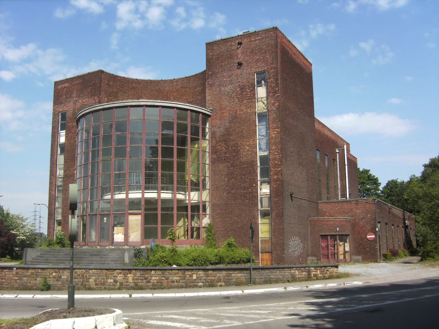
In the south-east of the city, in the Couillet district, the Amicale Solvay is the building most visited by the region's explorers. Built between 1937 and 1939 by the architect Éléazar Cozac for the staff of the Solvay factories, this large flat-roofed brick building housed an indoor swimming pool, a performance hall and a restaurant - a genuine workers' leisure complex, in the pure modernist style of the interwar years.
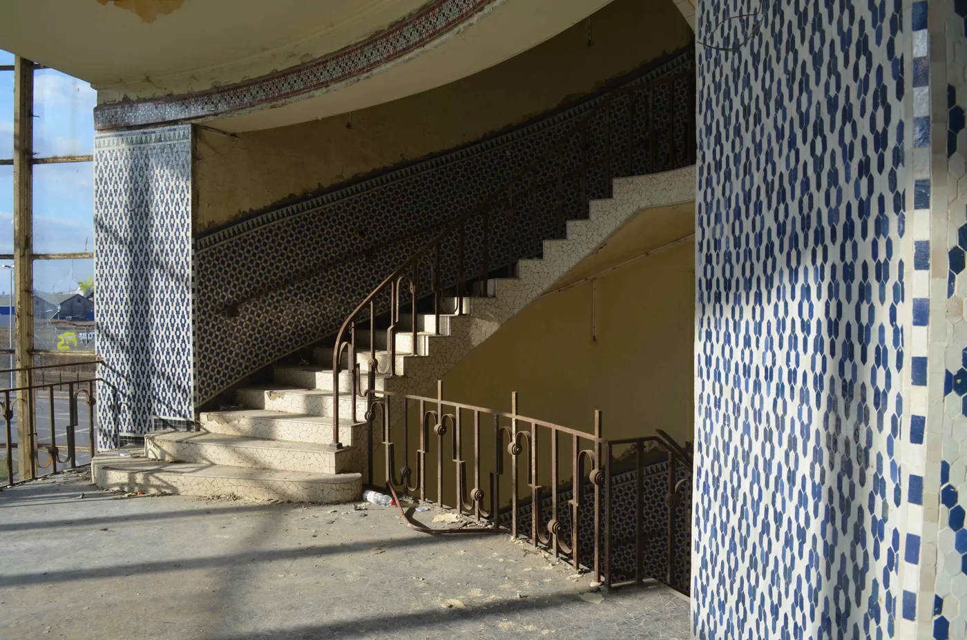
The pool closed in 1998, and the complex has been disused ever since. The building has been listed as Walloon heritage since 2000 (facades, roofs, rotunda hall and pool), which has protected it from demolition. Several conversion projects - swimming school, mosque, coworking space - failed for lack of funds; in February 2025, the buyout by the City was definitively buried. The building therefore remains standing, empty, and even more photogenic with its intact blue tiles and its terrazzo staircase.
It is private property closed to the public, where access is not authorised. The risks: weakened floors, a dry basin with broken edges, falling glass and plaster. The Solvay pool remains the most iconic spot of urbex in Charleroi - a modernist dream frozen in time.
2. Du Gouffre Colliery No. 10 - the last shaft of the basin
To the east, in Châtelineau (municipality of Châtelet), the du Gouffre colliery No. 10 is the main headquarters and the last shaft of the Charbonnages du Gouffre company. Brought into service in 1916, with its concrete and brick buildings erected around 1934, it dug coal until its closure on 31 March 1969. Its two shafts were filled with concrete when the activity stopped; the site briefly housed a zoo between 1979 and 1982, then a car scrapyard.
Abandoned for more than fifty years, the colliery now offers its large empty halls, its eaten-away brick arches and a panoramic viewpoint over the basin and its slag heaps. It's one of the recommended spots to start with: easy to spot, readable, and beautiful to photograph in raking light. A redevelopment project (decontamination, housing, green spaces) is under study, but the ruined buildings are still there in 2026.
The land is private and access is not authorised. The classic risks of a colliery: unstable masonry, collapsed floors, gaping openings above the old shafts. Le Gouffre tells, better than a museum, the end of the mining epic of the Black Country.
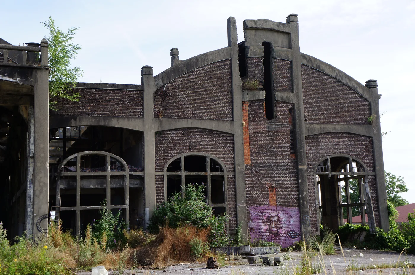
3. Providence Coking Plant - the ovens of Marchienne
To the north-west, in Marchienne-au-Pont, along the Sambre, the Providence coking plant (known as the Marchienne coking plant) dates back to 1838, when the Forges de la Providence company installed its first coke ovens. Modernised and enlarged in the 1980s to 122 ovens and 750,000 tonnes of metallurgical coke per year, it fed the Charleroi steel industry for a century and a half.
The coking plant closed in 2008 along with the rest of the steel site, throwing 250 people out of work. Since then it has been slowly decaying, overrun by vegetation, its oven batteries and its quenching towers rising above the scrub. An overall demolition has been started at a slow pace, but most of the brownfield is still standing in 2026, offering spectacular views over the city.
A private site undergoing dismantling, closed and guarded: you read it from the surroundings rather than going inside. Major dangers: polluted soils, weakened structures, remnants of asbestos and coking by-products. The Providence coking plant is the black and monumental face of industrial Charleroi.
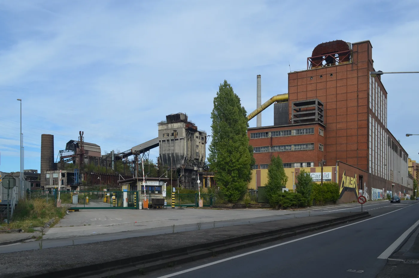
4. Cockerill-Sambre - the power station of the dead steel industry
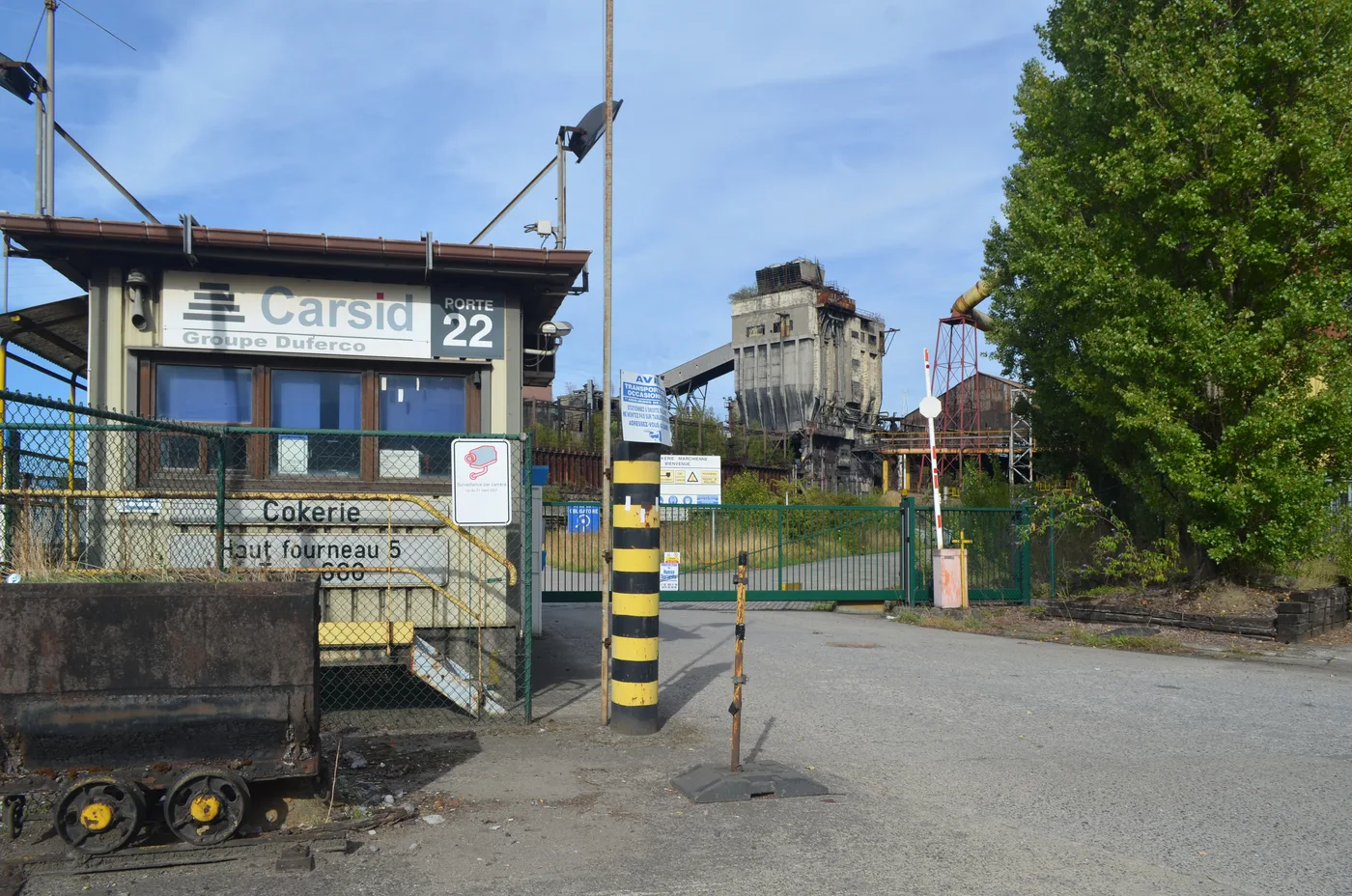
On the north bank of the Sambre, adjoining the coking plant, stands the power station of the Cockerill-Sambre steelworks, which English-speaking explorers nicknamed the "Blue Power Plant" because of its large Escher Wyss turbine with its blue cowling. It produced the electricity of the steel complex by burning coke-oven gas - a closed loop typical of Walloon heavy industry. Its turbines, from 6.5 to 75 MW, were genuine museum pieces.
The shutdown of the Charleroi steel industry in 2008 (Carsid, ex-Cockerill-Sambre) froze everything in one go. Since then, the machine hall and its turbines have stayed silent beneath the shattered glass roofs. In 2024-2025, exploration reports confirm that the weathered walls of the power station are still standing; as for the rest of the site, the future is demolition, with no known date. It's one of the last great power-station interiors still visible in the basin.
The steel site is private, fenced and guarded: you observe it from the public domain. Dangers: open pits, corroded walkways, asbestos and heights. For the full map of the basin's brownfields, head to our urbex Belgium pillar, which also covers the neighbouring Power Plant IM and Blast Furnace 4.
5. The ghost metro - the stations that never opened
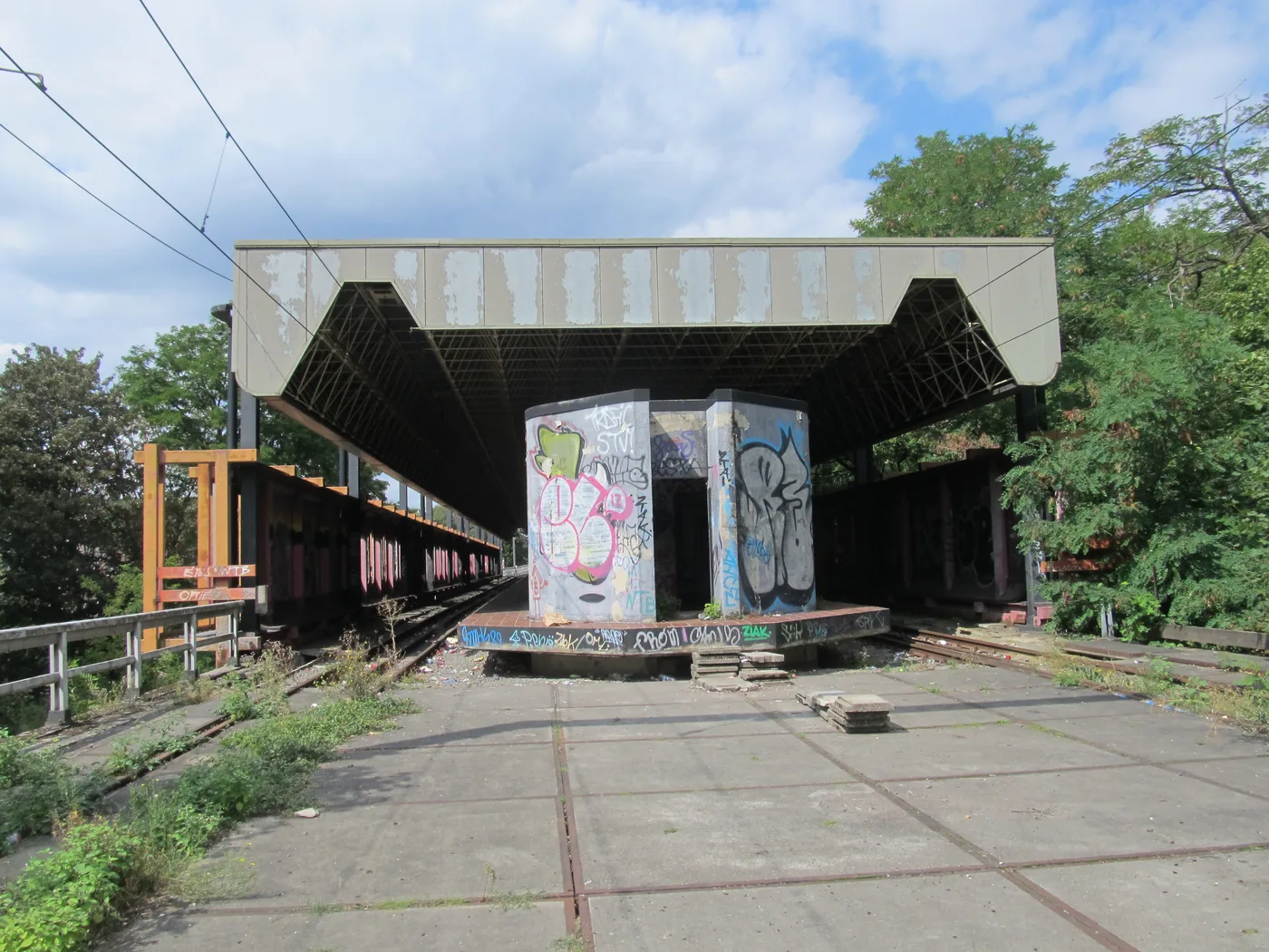
A unique curiosity in Europe: the Charleroi light rail was built in the 1980s with a branch towards Châtelet that was never brought into service. Four fully equipped stations - Neuville, Chêt, Pensée and Centenaire - completed in 1985-1987, remained closed for more than thirty-five years, with rails and overhead lines laid, without a single train ever running through them. A complete, brand-new metro, abandoned at the moment of its inauguration.
The reactivation project is finally moving forward: the return to service of part of the line is announced for 2027, with the renovation of several stations. But the deepest sections and the shell station Chêt, outside the works, remain a maze of tagged platforms, weed-overgrown tracks and bare concrete - the ghost-metro setting that urbexers come looking for. The window to see it in this state is closing: to be explored before the works are finished.
Property of the transport company, access forbidden and now partly a worksite: absolute caution. Dangers: falls from the platforms, dark tunnels, sections under works. The exact coordinate of the ghost station isn't in our database yet - it will be added to the map of Hainaut with its on-the-ground verification.
6. Gralex Quarry - the forbidden lake of Mont-sur-Marchienne
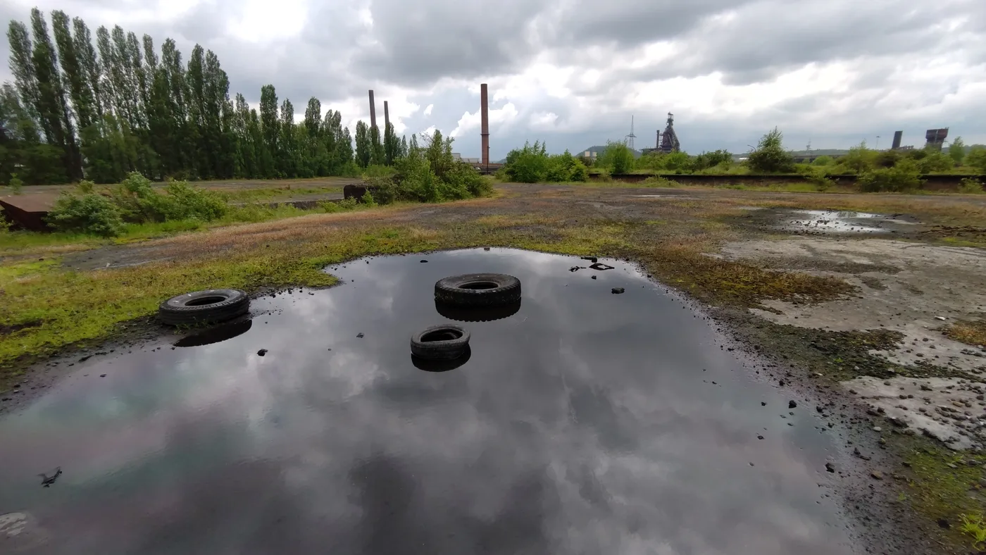
To the south, in Mont-sur-Marchienne, the former Gralex limestone quarry ceased all activity in 1998. Since then, nature has reclaimed its rights: the excavation has filled with turquoise water, and the sheer rock face, the vegetation and the silence make it a striking setting, halfway between an abandoned place and an improbable lagoon in the heart of the Black Country.
Be careful: this site is "forbidden and deadly", as the Charleroi police point out. The flooded quarry has caused several drownings; in summer, the authorities regularly evacuate bathers and carry out enforcement actions. The water is deep, icy even in a heatwave, the banks unstable. We document Gralex for what it is - a brownfield reclaimed by water - without ever swimming in it or venturing into it.
Private property, access strictly forbidden and fined. This sixth spot is to be contemplated from afar, from the heights; it isn't yet listed in our database and will join the map of Hainaut after verification. For hundreds of other unlockable places, see the urbex map of Wallonia.
FAQ - Urbex Charleroi
Is urbex legal in Charleroi?
Looking at and photographing a building from the public domain is legal. Entering private property without permission is trespassing, and becomes criminal as soon as there is damage or failure to respect a fence or a sign. Most of the spots on this list are private, listed or industrial: we document them for their history, without ever inciting anyone to break in. To go further, read our urbex Belgium guide.
Where can you find other abandoned places around Charleroi?
Our map lists thousands of spots across Hainaut and the rest of Wallonia. You can add the places from this article to your personal map for free via the button under each entry, then unlock the rest with our regional packs.
Are these abandoned places dangerous?
Yes. The Solvay pool has fragile floors and a dry basin, Le Gouffre concreted shafts and unstable halls, the coking plant and the Cockerill-Sambre power station polluted soils and asbestos, the ghost metro platforms and dark tunnels, and the Gralex quarry is deep and deadly water. Several can only be seen from outside the fences. Set off with company, take a headlamp and never enter a structure that looks unstable. Our urbex gear guide covers the essentials.
Which place should you start with in Charleroi?
The du Gouffre colliery is the most accessible and the most readable to start with: large empty volumes, easy to spot and lovely light. The Solvay pool offers the finest details (tiles, staircase, rotunda) but remains a listed property to be observed with respect. The Marchienne steel brownfields, more dangerous, are best left to seasoned explorers.
Why is Charleroi Belgium's capital of urbex?
Because within a single generation, the Black Country saw its collieries close (the last Walloon mine, Le Roton, closed in 1984) then its steel industry collapse (2008). This density of brownfields, within tram reach and concentrated over a few kilometres along the Sambre, is unique in Europe. The city even gave rise to "post-industrial" tourism with official urban safaris.
Conclusion: Charleroi, the industrial epic in the open air
From the Art Deco swimming pool of Couillet to the dead turbines of Cockerill-Sambre, the abandoned places of Charleroi tell the story of a city of miners, coke workers and steelworkers - and of the closures that left these cathedrals behind. They are not film sets: they are open-air history books, fragile, to be explored with respect and without damaging anything, several already promised to demolition. Add them to your map, and carry on with our top 10 abandoned places in Belgium or the urbex map of Hainaut.