Urbex in Toulon has a colour of its own: military concrete and maritime rust. Toulon is above all a garrison and naval-arsenal town, which means two things for the explorer. First, that most of the bay's fortified heritage is either restored and turned into a museum (Fort Napoleon, Peyras battery, Tour Fondue) or still occupied by the Navy. Second, that the real abandoned places are on the hills ringing the roadstead and in the industrial wastelands of La Seyne-sur-Mer, on the edge of the urban area. On our map, thousands of geolocated spots cover the Var and the whole Provence-Alpes-Cote d'Azur region.
For this article we picked 4 places that are genuinely abandoned and still standing in 2026, each verified one by one: a ruined coastal fort blown apart by two explosions, a large naval-shipyard wasteland, a forgotten fortin on its rocky spur and a final work of Toulon's defensive ring. No demolished spots, no museum passed off as a ruin. Toulon does not have four real spots in its very centre: when a city has no four spots at its core, we widen the radius rather than sell you renovated sites. Under each entry, an "Add to my map" button saves the GPS coordinates to your personal account, for free and with no credit card.
The queries urbex Toulon, Toulon urbex map, abandoned places Toulon, urbex spot Var, urbex around Toulon and urban exploration Var all point to the same reality: a coastal military and industrial heritage that history set aside - military withdrawals, accidents, the bankruptcy of the shipyards - and that photographers, urbexers and historians are rediscovering today. This guide gives you each site's dated history, its legal status and its real dangers, before handing you its coordinates.
Free Toulon urbex: why Urbex Maps changes the game
Before the spots, a word on what makes this guide different. Most sites that talk about free urbex in Toulon put "free" in the title, then redirect you to a paid forum or a closed Telegram group. Here the promise is concrete: under each place, an "Add to my map" button sends the GPS coordinates to your personal account, with no subscription and no credit card.
Behind the map is a community of more than 40,000 explorers, active since 2021. Every coordinate is checked at least twice - by the contributor who submits it, then by a regional moderator who confirms the spot still exists and has not been walled up. The places offered in this article are part of that catalogue; the rest of the thousands of French spots are unlocked through packs that fund the moderation and field verification.
One reminder before you set off: urbex is not illegal in itself, but entering private property without permission is trespassing (article 226-4 of the French Penal Code, up to one year in prison and a 15,000 euro fine). We document these places for their history; we never encourage breaking in. Be aware too: around Toulon, several forts sit on Conservatoire du littoral land classed "no public access" because of genuine danger. Helmet, torch, ankle boots and the utmost caution.
1. Fort de la Colle Noire - the fort blown apart by two explosions (Le Pradet)

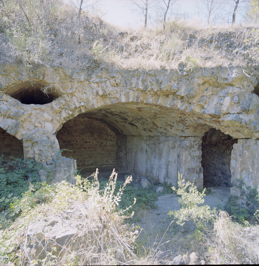
Built between 1878 and 1880 on the summit of the Colle Noire massif, at about 294 metres, the Fort de la Colle Noire is the easternmost of the detached works of the Sere de Rivieres system tasked with protecting the Toulon roadstead. Its history turned after the war: on 17 August 1946, an explosion in its ammunition depot destroyed half the fort; a second explosion on 7 August 1949 completed the ruin. The gorge front, the gate, the barracks and a whole flank were blown away. The fort was then abandoned for good. Source: the Region Sud general heritage inventory.
What survives is spectacular: underground galleries and casemates from 1889, eastern casemates in good condition, and all around gutted stretches of wall reclaimed by the garrigue. The site belongs to the Conservatoire du littoral and has been managed since 2006 by the Toulon Provence Mediterranee metropolitan authority. It is officially "no public access": the land is fenced, the hill was long considered partly "mined", and ammunition re-exploded during a fire in 2005. The remains are still visible from the hiking trail that crosses the massif.
To reach it, the usual starting point is the Pas des Gardeens, in the La Garonne district (Le Pradet), about ten kilometres east of Toulon. The climb is on foot along the massif's fortress trail. The coordinates below point to the fort itself, at the summit of the massif (OpenStreetMap historic=fort node "Fort de la Colle Noire", cross-checked via Nominatim/Overpass, agreement ~3 m). Main risks: unstable ruins, theoretical leftover explosives, drops and rough ground.
La Colle Noire remains the most iconic spot of Toulon's eastern belt: a raw ruin shaped by two explosions, the kind you rarely see.
2. Chantiers maritimes du Midi - the naval wasteland of Balaguier (La Seyne-sur-Mer)
On the other side of the roadstead, in La Seyne-sur-Mer, the Balaguier cove holds the only truly civil, industrial spot in this guide: the former Chantiers maritimes du Midi (CMM). Opened in 1917 to build wooden barges and boats, the yard was later bought by CNIM, then closed in the 1980s. It still belongs to CNIM and has never been converted: "the reconversion of the site is still under discussion, with no solution in sight". Not to be confused with the large FCM site (Forges et Chantiers de la Mediterranee), which was redeveloped into the Parc de la Navale - the CMM site at Balaguier is distinct and still a wasteland.
On site, a hangar remains on the corniche edge, a large warehouse of which only the walls survive, plus slipways and a pier. Everything is tagged: the place has become a street-art playground, extensively documented by explorers and local media. The structure is decayed and dangerous (floors, roofs, scrap metal). Access has been found open in places, but the land remains private property of CNIM: entering without permission is still trespassing. It is a spot to approach with caution, ideal for industrial-wasteland photography.
The yard sits along the Voie communale Bonaparte (Tamaris corniche), about five kilometres west of Toulon across the roadstead. The coordinates below point to the shipyard location, at the site's historical address.
3. Fortin de la Gavaresse - the forgotten work on its spur (Carqueiranne)
On the south-west slope of the same Colle Noire massif, at about 225 metres above the Garonne bay, hides the Fortin de la Gavaresse. Built in 1880-1881, this Sere de Rivieres coastal work with a pentagonal enclosure, armed with four 24 cm guns, rounded out the defence of the Toulon roadstead. It has been abandoned since the interwar years: never reoccupied in 1939-1945, never modernised. We own the point: this is exactly the kind of spot you widen the radius for when the city centre offers nothing.
The fortin now belongs to the Conservatoire du littoral and its access is officially "no public access". The structure stands but has decayed: the drawbridge is gone (replaced by a fixed walkway), the railings have been removed and a 20th-century shed was demolished. The large vaulted rooms and the terrace survive, with a view over the entire coastline. The Garonne bay coastal trail passes close to the remains.
Gavaresse and Colle Noire are on the same massif, a few hundred metres apart but at different altitudes (225 m versus 294 m): they are two distinct works that you can chain on the same hike. The coordinates below point to the fort's footprint itself (OpenStreetMap historic=fort way, altitude confirmed at 224.65 m by IGN elevation data). Risks: an old, unmaintained structure and steep terrain.
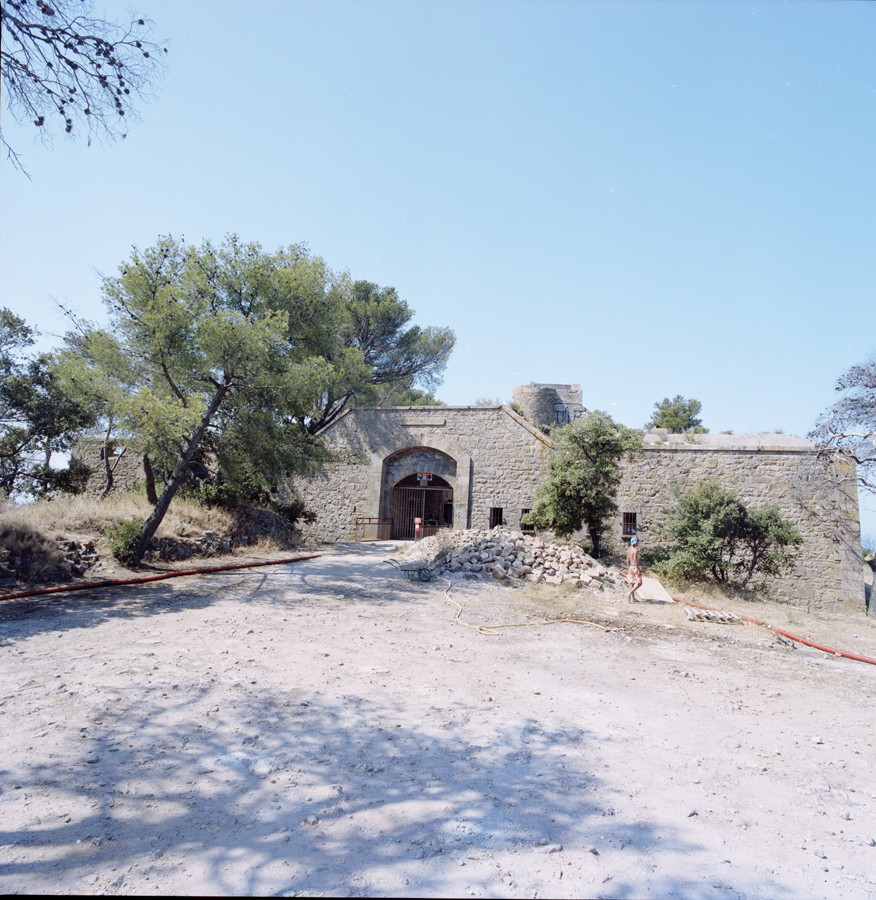
4. Mauvanne battery - the Var's Atlantic Wall (Hyeres)

For anyone willing to push up to the heights of Hyeres, between the town and La Londe-les-Maures, the Mauvanne battery is a direct dive into the Second World War. Originally a French coastal battery from 1890, the site was heavily concreted by the Germans in 1944 (position Bor 003): four M272 casemates for 150 mm guns, a fire-control post and a magazine. The battery fell to the Allied assault on 18 August 1944, during the landing in Provence and the advance on Toulon - combat impacts and a crater on the roof of the fire-control post still bear witness.
The reinforced-concrete work is largely intact, making it one of the most impressive fortified complexes in the area. Mind the status: the battery was left abandoned for many years, made available to an association in 1998, and recent information on its ownership is contradictory (the land is presented sometimes as freely accessible, sometimes as sold to a private owner). Treat it as a war structure to approach with caution, on land whose status you must check on the spot. Access is on foot, via a track crossing the wine-growing heights, about eighteen kilometres east of Toulon. It is the last link in our widening eastward across the Var. Find every spot in the area on the Var map.
FAQ - Urbex Toulon
Is urbex legal in Toulon?
Urban exploration is not illegal in itself, but entering private property without permission is trespassing (article 226-4 of the French Penal Code). Around Toulon, several forts belong to the Conservatoire du littoral and are classed "no public access" because of genuine danger: we document them for their history, without ever encouraging break-ins. For more, read our guide is urbex legal in France.
Where can I find other abandoned places around Toulon?
Our map lists thousands of spots across the Var and neighbouring departments. You can add the four places in this article to your personal map for free via the button under each entry, then unlock the rest through our regional packs. If you are heading west across the region, see also our guide urbex in Marseille.
Do I need special gear to explore the Toulon forts?
For the coastal forts (Colle Noire, Gavaresse), good ankle boots and a torch are essential for the galleries and casemates; the terrain is steep and the ruins unstable. For the La Seyne shipyard wasteland, watch out for floors and scrap metal. Our urbex gear guide covers the essentials to start safely.
Why so few spots in central Toulon?
Toulon is a naval-arsenal and garrison town: its fortified heritage is either still occupied by the Navy or restored into a museum (Fort Napoleon, Peyras battery, Tour Fondue). The real abandoned places are therefore on the roadstead's hills and in the La Seyne wastelands. When a city has no four spots at its core, we honestly widen the radius rather than present a museum as a ruin.
Conclusion: Toulon, a roadstead bristling with forgotten concrete
From the blown-apart Colle Noire fort to the Mauvanne blockhouses, by way of the La Seyne naval wasteland, Toulon urbex tells a century and a half of military and industrial history: the fear of an attack on the roadstead that bristled the hills with forts, the landing in Provence, and the end of the great naval shipyards. These places are not stage sets: they are open-air history books, fragile, to be explored with respect and without damage. Add them to your map, and carry on your exploration with the free urbex map.