Urbex in Nice does not happen in the postcard city of the Promenade des Anglais, but in its hinterland: a landscape of fortified hills, perched villages emptied of their inhabitants, and sanatoriums set on the plateaus of the Niçois back country. Between the casemates of the Fort de la Drete on the Grande Corniche, the medieval ruins of Vieil Aspremont and the forgotten arsenic mines above Duranus, urban exploration on the Riviera has to be earned on foot. On our map, thousands of geolocated spots cover the Alpes-Maritimes and the whole Provence-Alpes-Cote d'Azur region.
For this article we picked 4 places that are genuinely abandoned and still standing in 2026, each verified one by one: a decommissioned fort of the Nice belt, a sanatorium closed since 1978, a fortified village deserted in the 17th century, and the old arsenic mines of a Mercantour valley. No demolished spots, no renovated site passed off as a ruin. Under each entry, an "Add to my map" button saves the GPS coordinates to your personal account, for free and with no credit card.
The queries urbex Nice, Nice urbex map, abandoned places Nice, urbex spot Nice, urbex around Nice and urban exploration Alpes-Maritimes all point to the same reality: a military, religious and mining heritage that history set aside - military withdrawals, the end of tuberculosis, dried-up springs, rural exodus - and that photographers, urbexers and hikers are rediscovering today. This guide gives you each site's dated history, its legal status and its real dangers, before handing you its coordinates.
Free Nice urbex: why Urbex Maps changes the game
Before the spots, a word on what makes this guide different. Most sites that talk about free urbex in Nice put "free" in the title, then redirect you to a paid forum or a closed Telegram group. Here the promise is concrete: under each place, an "Add to my map" button sends the GPS coordinates to your personal account, with no subscription and no credit card.
Behind the map is a community of more than 40,000 explorers, active since 2021. Every coordinate is checked at least twice - by the contributor who submits it, then by a regional moderator who confirms the spot still exists and has not been walled up. The places offered in this article are part of that catalogue; the rest of the thousands of French spots are unlocked through packs that fund the moderation and field verification.
One reminder before you set off: urbex is not illegal in itself, but entering private property without permission is trespassing (article 226-4 of the French Penal Code, up to one year in prison and a 15,000 euro fine). We document these places for their history; we never encourage breaking in. Helmet, torch, ankle boots and caution on the floors: most of the spots below carry real collapse risks, and two of them require a genuine mountain hike.
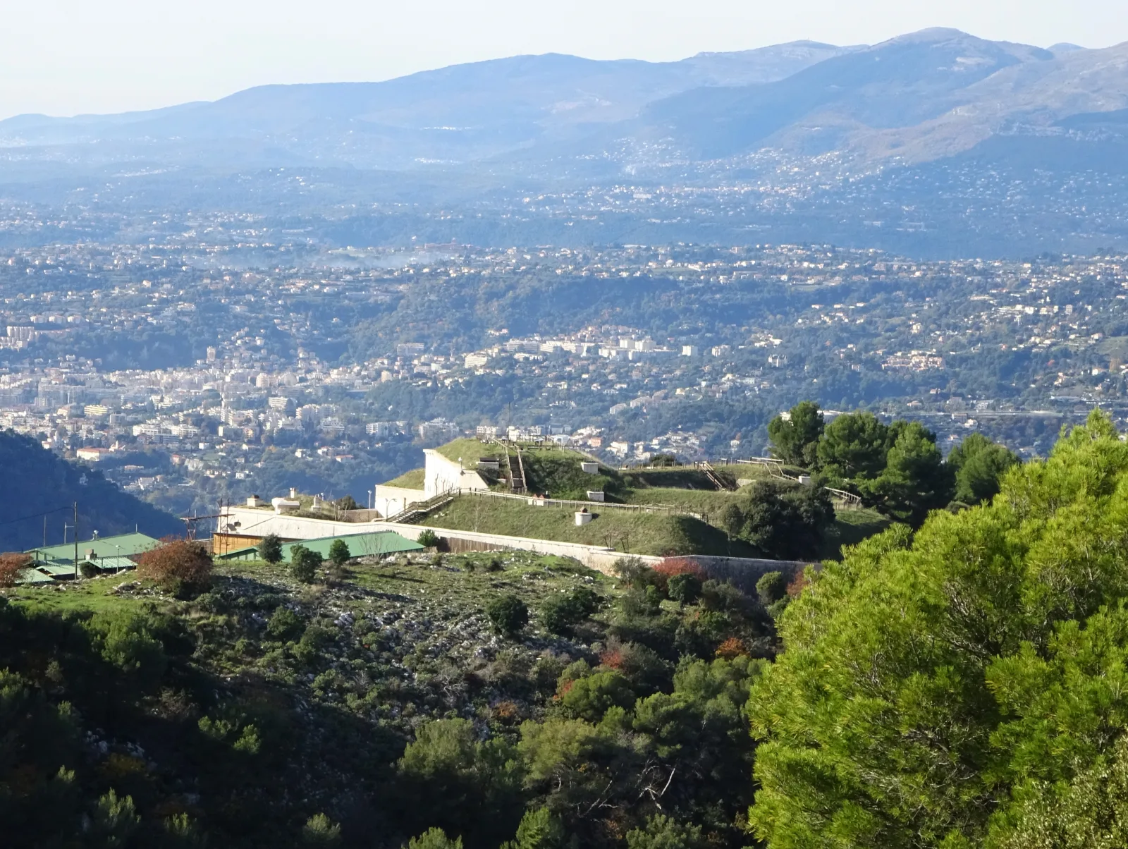
1. Fort de la Drete - the forgotten fort of the Grande Corniche (La Trinite)

Built between 1879 and 1882 in the commune of La Trinite, just east of Nice, the Fort de la Drete is a blocking fort of the Sere de Rivieres system, raised after 1871 to counter an Italian invasion and to hold the stronghold of Nice. A small work measuring 180 by 90 metres, it forms one of the locks of the eastern belt of the entrenched camp of Nice. After 1973 it served as a barracks and depot for the Nice alpine rifle battalion, then was decommissioned and included in the Grande Corniche departmental natural park, occupying its north-western corner. Source: General inventory of cultural heritage.
The fort keeps its vaulted casemates, its ditch, its caponier and its buried powder magazine, all caught in the scrubland of the Grande Corniche. It is the archetypal Sere de Rivieres mountain fort: massive, half-buried, facing the Italian border. The town of La Trinite opens it exceptionally during the Heritage Days, a sign it is still standing and visited, but for the rest of the year the work is left to itself.
The fort sits inside a departmental park whose trails are open, but the interior of the work is not freely accessible outside guided visits. Main risks: deep ditches, uneven ground, dark rooms and falling stone. A torch and ankle boots are recommended. You reach the area from the Grande Corniche (D2564) above La Trinite, about ten kilometres from central Nice.
Fort de la Drete remains the most accessible military spot of the Nice ring: the best entry point to understand the city's fortified belt.
2. The Felix-Zehetner sanatorium - the frozen hospital of Bas-Thorenc (Andon)
About fifty kilometres north-west of Nice, on the Caussols-Thorenc plateau (commune of Andon), stands the former Felix-Zehetner sanatorium, also known as the Bas-Thorenc Clergy sanatorium. Built on the remains of an older structure, this large high-altitude cure facility operated as a hospital until its closure in 1978. Since then it has been left abandoned: deserted corridors, gutted rooms and an empty chapel make it one of the most striking abandoned backdrops in the Nice back country.
An important point to know: the building is increasingly walled up. As early as 2017, workers began sealing the entrances with breeze blocks, and the place closes off year after year - so it is a spot to observe and photograph from the outside rather than to enter, and its status can change from one season to the next. It is private property: the interior is not accessible without permission. Standard risks of a large abandoned medical building: unstable floors, stairwells, likely asbestos. Access via the D2 towards Andon, at altitude (expect a mountain road).
The Felix-Zehetner perfectly illustrates how fragile urbex is: one to document while it is still standing, before the breeze blocks seal it completely.
3. The ruins of Vieil Aspremont - the abandoned upper village (Aspremont)
Above the present-day village of Aspremont, less than ten kilometres north of Nice, lie the ruins of Vieil Aspremont: the remains of the perched medieval village, deserted in favour of the site below. Dry-stone walls, terraces and collapsed house sections still cling to the ridge, in a landscape typical of the hilltop villages that medieval Nice multiplied for protection. It is a good example of widening the radius into the hinterland, where village-ruin urbex is far richer than in the city.
The site is freely reachable by the trails, but these are genuine unstable ruins: walls that may collapse, uneven ground, dense vegetation. Ankle boots are essential, and constant caution about what you climb on. You walk up from Aspremont (the village), about twenty minutes from Nice by car. Combine it with the other ruins of the commune for a half-day of heritage exploration.
4. The Eguisse mines and the cursed village of Rocca Sparviera (Duranus)
For anyone willing to take a real hike from Duranus, the valley holds two abandonments in a row. First the old arsenic mines of l'Eguisse, worked and then forsaken, whose galleries and ruined buildings are now reclaimed by vegetation. Higher up, at 1,100 metres, the ruins of the ghost village of Rocca Sparviera - "the rock of the sparrowhawks" - abandoned around 1723 when its spring dried up. The village once had up to 350 inhabitants; only wall sections, a Saint-Michel chapel and the famous legend of Queen Jeanne, who is said to have cursed the place, remain. Source: Randoxygene (Alpes-Maritimes department).
Be careful: this is a demanding mountain hike (about 12 km, more than 900 metres of climb, allow half a day), best avoided in July and August for lack of shade. The mine galleries and the ruins are unstable: you look, you photograph, you do not crawl into a shaft. The waymarked trail makes this set the most "legal" spot in the selection, since you stay on a public hiking route. The free GPS point below marks the Eguisse mines, on the path climbing towards Rocca Sparviera. Find every spot in the area on the Alpes-Maritimes map.
FAQ - Urbex Nice
Is urbex legal in Nice?
Urban exploration is not illegal in itself, but entering private property without permission is trespassing (article 226-4 of the French Penal Code). Several Nice spots are private (the Bas-Thorenc sanatorium) or in a departmental park (the Fort de la Drete): we document them for their history, without ever encouraging break-ins. The ruins of Vieil Aspremont and the Rocca Sparviera trail, on the other hand, are reached by public paths. For more, read our guide is urbex legal in France.
Where can I find other abandoned places around Nice?
Our map lists thousands of spots across the Alpes-Maritimes department and the Provence-Alpes-Cote d'Azur region. You can add the four places in this article to your personal map for free via the button under each entry, then unlock the rest through our regional packs.
Do I need special gear to explore the Nice back country?
For the Fort de la Drete and the Bas-Thorenc sanatorium, a torch and ankle boots are essential, and an FFP3 mask is recommended in the old hospital because of likely asbestos. For Rocca Sparviera and the Eguisse mines, it is mainly mountain hiking gear (water, trail shoes, sun protection). Our urbex gear guide covers the essentials to start safely.
Can you still get inside the Felix-Zehetner sanatorium?
Less and less. The building has been progressively walled up since 2017 and its access closes off year after year; it is private property and entry is not authorised. It is best treated as a spot to photograph from the outside. Its status can change quickly: always check on site before planning anything.
Conclusion: Nice, a city to explore in its heights
From the Fort de la Drete on the Grande Corniche to the cursed ruins of Rocca Sparviera, Nice urbex tells of the fear of invasion that bristled the hills with forts, the fight against tuberculosis on the high plateaus, and the abandonment of whole villages when the water or the border receded. These places are not stage sets: they are open-air history books, fragile, to be explored with respect and without damage. Add them to your map, and carry on your exploration with our top 20 abandoned places in France or the free urbex map.