Urbex in Antwerp tells the story of a city that barricaded itself behind two rings of forts, that stored the petroleum of Europe on the southern bank of the Scheldt and that fired its bricks along the Rupel for centuries, before wars, the end of coal and speculation left those worlds behind. Between the gutted brick walls of the Fort van Walem, the vegetation-drowned casemates of the Fort van Steendorp and the chimney of the Interescaut power plant standing at the water's edge, Antwerp and its province are one of the densest terrains for urban exploration in Belgium. Our map lists thousands of geolocated spots in the province of Antwerp and the rest of Belgium.
For this guide, I selected 6 places that are genuinely abandoned and still standing in 2026, verified one by one: three ruined forts of the Stelling van Antwerpen (the fortified position of Antwerp), a listed petroleum quarter frozen while awaiting its conversion, one of the largest coal-fired power plants in Europe now shut down, and an old Rupel brickworks. No demolished monument disguised as a living spot, no restored attraction dressed up as a ruin. Beneath each eligible entry, an "Add to my map" button saves the GPS coordinates to your personal account, free and with no bank card.
The searches urbex Antwerp, urbex Antwerpen, abandoned places Antwerp, verlaten plaatsen Antwerpen and lost places Antwerpen all point to the same reality: a military, industrial and port heritage that history set aside through the dismantling of the forts, the closure of the power plants and the end of the brickworks, and that photographers, urbexers and historians are rediscovering today. This guide gives you, for each site, its dated history, its legal status and its real dangers, before entrusting you with its coordinates.
Urbex Antwerp free: why Urbex Maps changes the game
Before the spots, a word on what sets this guide apart. Most pages about abandoned places in Antwerp put "free" in the title, then send you to a closed Facebook group, a forum or a paywall. Here the promise is concrete: beneath each eligible place, an "Add to my map" button drops the GPS coordinates into your personal account, with no subscription and no bank card.
Behind the map is a community of more than 40,000 explorers, active since 2021. Each set of coordinates is verified at least twice - by the person who reports it, then by a regional moderator who confirms that the spot still exists and has not been walled up or demolished. The places offered for free in this article are part of that catalogue; the rest of the thousands of Belgian spots unlock through packs that fund moderation and on-the-ground verification.
A reminder before you set off: urban exploration is not illegal in itself, but entering private property without permission is trespassing, and it becomes a criminal matter the moment you cause damage or ignore signs and fences. We document these places for their history; we never encourage break-ins. Helmet, headlamp, high boots and caution on the ground: several of the spots below present real risks of collapse and asbestos, and both the power plant and the petroleum quarter run alongside the deep water of the Scheldt.
1. Fort van Walem - the fort gutted by the shells of 1914 (Mechelen)
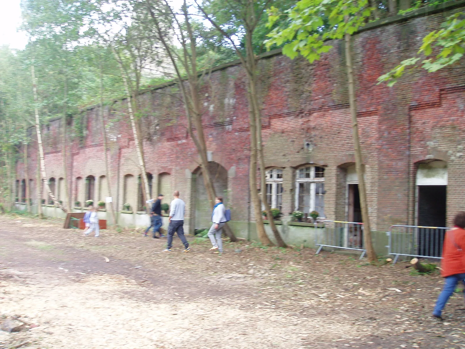
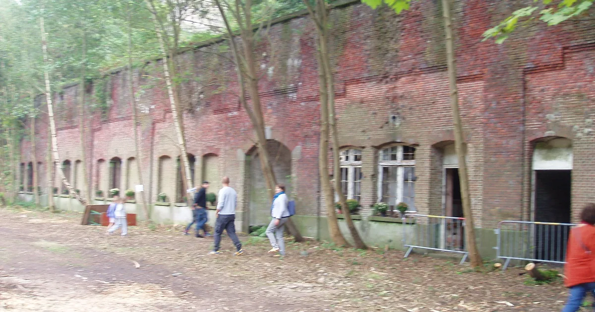
At Walem, on the territory of Mechelen in the province of Antwerp, the Fort van Walem is one of the most spectacular war ruins of the Antwerp ring. Built between 1878 and 1893 in the second ring of forts designed by General Henri Alexis Brialmont, it was a brick artillery fort meant to protect the south-eastern approach to the city.
Its history tips over in the autumn of 1914. From 28 September to 2 October, German artillery pounded it with its 305 mm howitzers; one shell struck the main powder magazine, and the explosion killed some forty men and tore away whole sections of the building. The fort would never recover. Bought by the nature conservation association Natuurpunt in 2009, it today shelters a bat reserve, but the masonry was left as it was: in many places, it is a genuine ruin.
The site is private property managed as a nature reserve, dilapidated and dangerous to enter: pierced vaults, collapsed sections, stagnant water. You read it as it is - a brick fortress that the forest is swallowing - and you understand why it remains the most telling fortified ruin around Antwerp. This fort is the best starting point for anyone wanting to understand the city's defensive ring.
2. Fort van Steendorp - the brick fortress eaten by the forest (Temse)
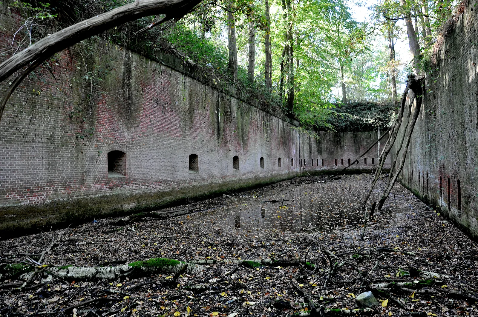
At Steendorp, in the municipality of Temse, just across the Scheldt but fully integrated into the fortified ring of Antwerp, the Fort van Steendorp is a colossus of brick. Erected between 1882 and 1892 as a bridgehead fort under the name Fort Rupelmonde, at the time of its construction it was the largest fort of the Antwerp position and the last Belgian fort built in brick masonry.
After the Second World War, the fort gradually fell into ruin and the forest reclaimed its rights. Since 2001, it has belonged to the Agentschap voor Natuur en Bos and is today one of the most important bat hibernation sites in Flanders, with more than 1,200 individuals of nine species sheltering beneath its vaults. The building itself was not restored: it is a setting of loopholes, counterscarps and ivy-drowned galleries.
Listed both as a historic monument and as a European nature reserve, the fort itself can only be visited with a guide, through the Temse tourism service; a waymarked path of about two kilometres runs around it. It is the most photogenic spot of the ring: an entire fort returned to nature, to be looked at and photographed from the trail without ever forcing a gate.
3. Petroleum-Zuid - the frozen petroleum quarter of Antwerp (Antwerp)
On the southern bank of the Scheldt, south of the centre of Antwerp, Petroleum-Zuid was, from the late 19th century, the city's great hydrocarbon storage quarter: tanks, depots, overhead pipelines and boiler houses covered dozens of hectares. It is one of the most singular industrial landscapes in Belgium, with its brick chimney and its steel walkways from the 1930s.
Petroleum activity has died out and most of the site is today reconverted into the Blue Gate Antwerp business park. But a set of buildings was protected as heritage in 2016 and remains, itself, abandoned while awaiting its reassignment: the boiler house and its chimney, the overhead pipes on trestles, an old bunker and the warehouse of the American Petroleum Company. Walled-up windows, tall grass, rusted steel: the image of a quarter frozen in the middle of its redevelopment.
These remains lie within a fenced and guarded business zone, where active firms sit side by side: it is not a terrain for free wandering, but a heritage ensemble to read and photograph from the Scheldt quays and the public roads. Petroleum-Zuid remains the strongest witness to Antwerp's petroleum past - and the perfect industrial counterpoint to the forts of the ring.
4. Interescaut power plant - the coal-fired giant of the Scheldt (Schelle)
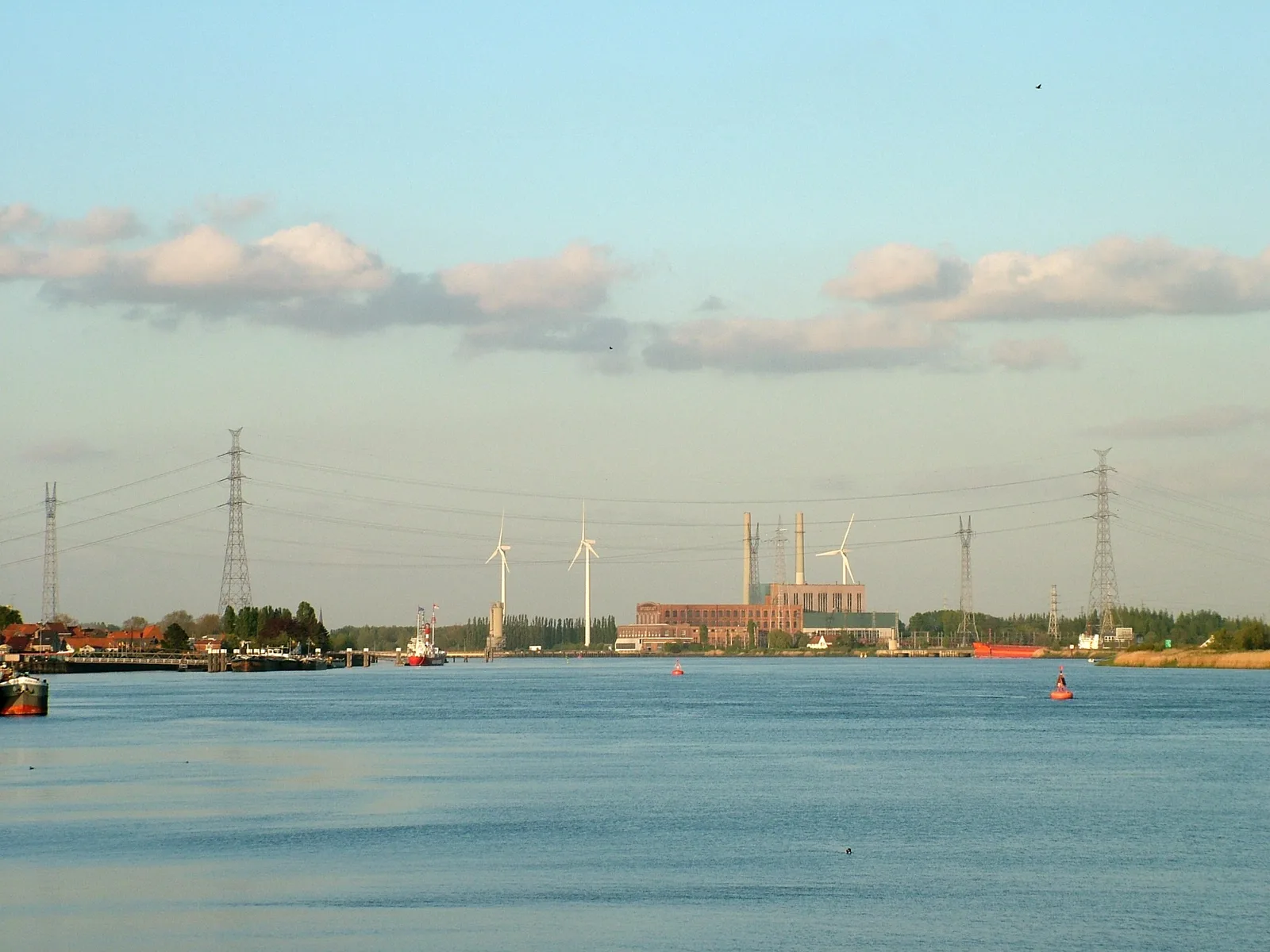
At Schelle, where the Rupel flows into the Scheldt, the Interescaut power plant raises its turbine hall and its administrative buildings at the water's edge. Inaugurated in 1930, it was for a time the largest coal-fired power plant in Europe and an essential node of the Flemish electricity grid. Its steam boilers and turbines ran for seventy years.
Electricity production stopped in 2000, and Electrabel ceased all activity on the site in 2016. Since then, the imposing turbine hall has remained standing, abandoned, awaiting a redevelopment plan led by the province of Antwerp. To discourage vandalism, the site occasionally hosts film shoots and temporary projects, but the essence remains an empty industrial cathedral on the Scheldt.
The site is a closed and dormant private property, ultimately destined for a project blending housing and nature: the window to observe it in its current state is slowly closing. You contemplate it from the bank or from the Rupel bridge, never by breaking in. This spot is not yet in the Urbex Maps catalogue: it is among the places our community is currently documenting for the province of Antwerp.
5. Fort van Bornem - the last fort of the ring, returned to the water (Bornem)
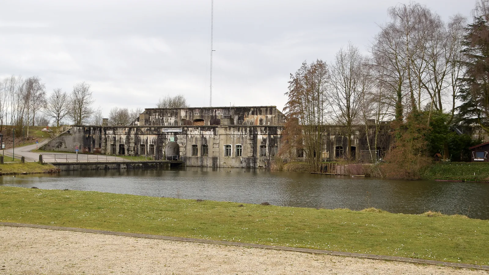
At Bornem, in the west of the province of Antwerp, the Fort van Bornem was the very last fort built for the fortified position of Antwerp. Work began in 1908 on an armoured fort in reinforced concrete, but its cupolas would never be fully installed. From 1914, the fort nonetheless entered service before surrendering on 10 October.
Passed into private hands around 1960, the estate was turned into a fishing reserve around the moats. But the fort itself, never restored, is in a deplorable state: wild vegetation, water infiltration, blocked drainage. It serves as winter quarters for hundreds of bats. It is a concrete fort entirely taken back by nature, reflected in the mirror of its moats.
The fort building is not accessible: only the banks and the walk around the water are. So you look at it from the path, without trying to enter a structure deemed dangerous. This spot is not yet in the Urbex Maps catalogue: it is among the places our community documents for the province of Antwerp.
6. De Neef-Landuyt brickworks - the chimney of the Rupel (Niel)
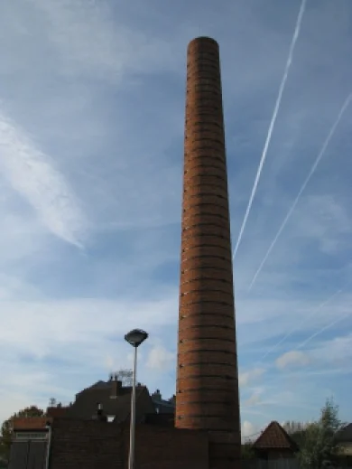
At Niel, in the heart of the brick country of the Rupel (Boom, Niel, Rumst), the former De Neef-Landuyt brickworks recalls the era when the region fired the bricks of all Belgium. The site, operated from 1905, had up to three ring kilns (ringovens), an office, drying sheds and a tall chimney along the Struyfstraat.
The Flemish heritage inventory is explicit: there remain today one abandoned ring kiln and a small office building at number 71 of the Struyfstraat, as well as a factory chimney on the neighbouring plot. It is one of the rare still-standing remnants of this vanished industry, where most of the Rupel brickworks were demolished or turned into a museum, like the Steenbakkerij Frateur of Noeveren.
The kiln and its office are a listed property on private land: fragile structure, weakened framework, access forbidden. You read this place for what it is - the last chimney of a valley that shaped all of Belgium's red-brick architecture. This spot is not yet in the Urbex Maps catalogue: it is among the places our community documents for the province of Antwerp. For the full map, explore our urbex map of the province of Antwerp.
FAQ - Urbex Antwerp
Is urbex legal in Antwerp?
Looking at and photographing buildings from public space is legal. Entering private property without permission is trespassing, and it can become a criminal matter the moment you cause damage or ignore fences and signs. Most of the places on this list are private, listed or managed as a nature reserve: we document them for their history, without ever encouraging break-ins. To go further, read our feature on abandoned places in Belgium.
Where can I find more abandoned places around Antwerp?
Our map lists thousands of spots in the province of Antwerp and the rest of Belgium. You can add the free spots from this article to your personal map at no cost via the button under each entry, then unlock the rest thanks to our regional packs.
Are these abandoned places dangerous?
Yes. The forts of Walem, Steendorp and Bornem present pierced vaults, unstable floors and flooded ditches; the Interescaut power plant and the Petroleum-Zuid quarter run alongside the deep water of the Scheldt and harbour rusted steel and probably asbestos. Several can only be seen from outside the fences. Never set off alone, take a headlamp, and never enter a structure that looks unstable. Our urbex gear guide covers the essentials.
What is the best abandoned place to start with in Antwerp?
The Fort van Steendorp is the most accessible and the most impressive: you discover it from a waymarked path of two kilometres, with no difficulty and no risk-taking. The Fort van Walem offers the rawest war ruin, but demands more caution on collapsed masonry. Both feature in our map of the province of Antwerp.
Conclusion: Antwerp, a city written in its ruins
From the brick forts of the Stelling van Antwerpen to the chimneys of the Rupel, by way of the tanks of Petroleum-Zuid and the turbine hall of Interescaut, the abandoned places of Antwerp tell of a city of soldiers, dockers and brickmakers - and of the wars, the closures and the redevelopments that left these monuments behind. They are not film sets: they are open-air history books, fragile, to be explored with respect and without damaging anything, several already returned to nature. Add them to your map, and continue with our feature on the 10 finest abandoned places in Belgium or the full urbex map of the province of Antwerp.