Urbex in Angers has a colour all of its own: that of slate. The capital of Anjou was built on top of a bedrock of schist, and history has left behind a whole mining, industrial and aristocratic heritage. Between the rusting headframes of the Trelaze slate mines, the closed foundries along the Loire and the chateaux devoured by vegetation south of Saumur, urban exploration in Angers mostly means accepting to widen the radius a little. On our map, thousands of geolocated spots cover Maine-et-Loire and the whole Pays de la Loire region.
Let's be honest from the start: the Angers area is heavily "cleaned up". Many flagship wastelands have been demolished or are under redevelopment - we left those out. For this article we picked 4 places that are genuinely abandoned and still standing in 2026, each verified one by one: a former slate mine, a foundry frozen by bankruptcy, a 1914 power station left as a wasteland, and a neo-Gothic chateau that was never lived in. No demolished spots, no renovated site passed off as a ruin. Under each entry, an "Add to my map" button saves the GPS coordinates to your personal account, for free and with no credit card.
The queries urbex Angers, Angers urbex map, abandoned places Angers, urbex spot Angers, urbex around Angers and urban exploration Maine-et-Loire all point to the same reality: a heritage of schist, metal and stone that history set aside - exhausted mines, industrial bankruptcies, abandoned projects - and that photographers, urbexers and historians are rediscovering today. This guide gives you each site's dated history, its legal status and its real dangers, before handing you its coordinates.
Free Angers urbex: why Urbex Maps changes the game
Before the spots, a word on what makes this guide different. Most sites that talk about free urbex in Angers put "free" in the title, then redirect you to a paid forum or a closed Telegram group. Here the promise is concrete: under each place, an "Add to my map" button sends the GPS coordinates to your personal account, with no subscription and no credit card.
Behind the map is a community of more than 40,000 explorers, active since 2021. Every coordinate is checked at least twice - by the contributor who submits it, then by a regional moderator who confirms the spot still exists and has not been walled up. The places offered in this article are part of that catalogue; the rest of the thousands of French spots are unlocked through packs that fund the moderation and field verification.
One reminder before you set off: urbex is not illegal in itself, but entering private property without permission is trespassing (article 226-4 of the French Penal Code, up to one year in prison and a 15,000 euro fine). We document these places for their history; we never encourage breaking in. Helmet, torch, ankle boots and caution on the floors: several of the spots below carry real collapse and pollution risks.
1. The Trelaze slate mines - the frozen mining country (Trelaze)

Barely five kilometres from Angers, Trelaze lived three centuries to the rhythm of slate. Its schist bedrock was carved out in deep underground mines, topped by metal headframes that hauled up the blocks and the men. The end is recent and dated: the last working pit, pit 7 Monthibert, closed for good on 29 March 2014. About a third of the buildings have since been demolished, but around eight headframes survive (Monthibert, Hermitage, Fresnais, Champ-Robert), standing over flooded shafts and ruined slate yards. Source: Wikipedia.
A key point to know before you come: a Slate Museum and a protected natural area operate alongside the old yard, and the industrial remains themselves are fenced off and access-restricted. So this is a spot to understand as a mining landscape - headframes, spoil heaps, flooded shafts to observe and photograph - rather than a building to enter freely. Not to be confused with La Poueze, l'Esperance or the Mine Bleue, which are restored and open for tourist visits: Trelaze remains a raw relic.
The risks are those of a mining site: flooded and unsecured shafts, collapsed galleries, unstable spoil heaps. Stay outside the barriers and never approach a shaft opening. It is the best entry point to understand where Angers comes from: without the slate of Trelaze, the city would not have the blue roofs that define its skyline.
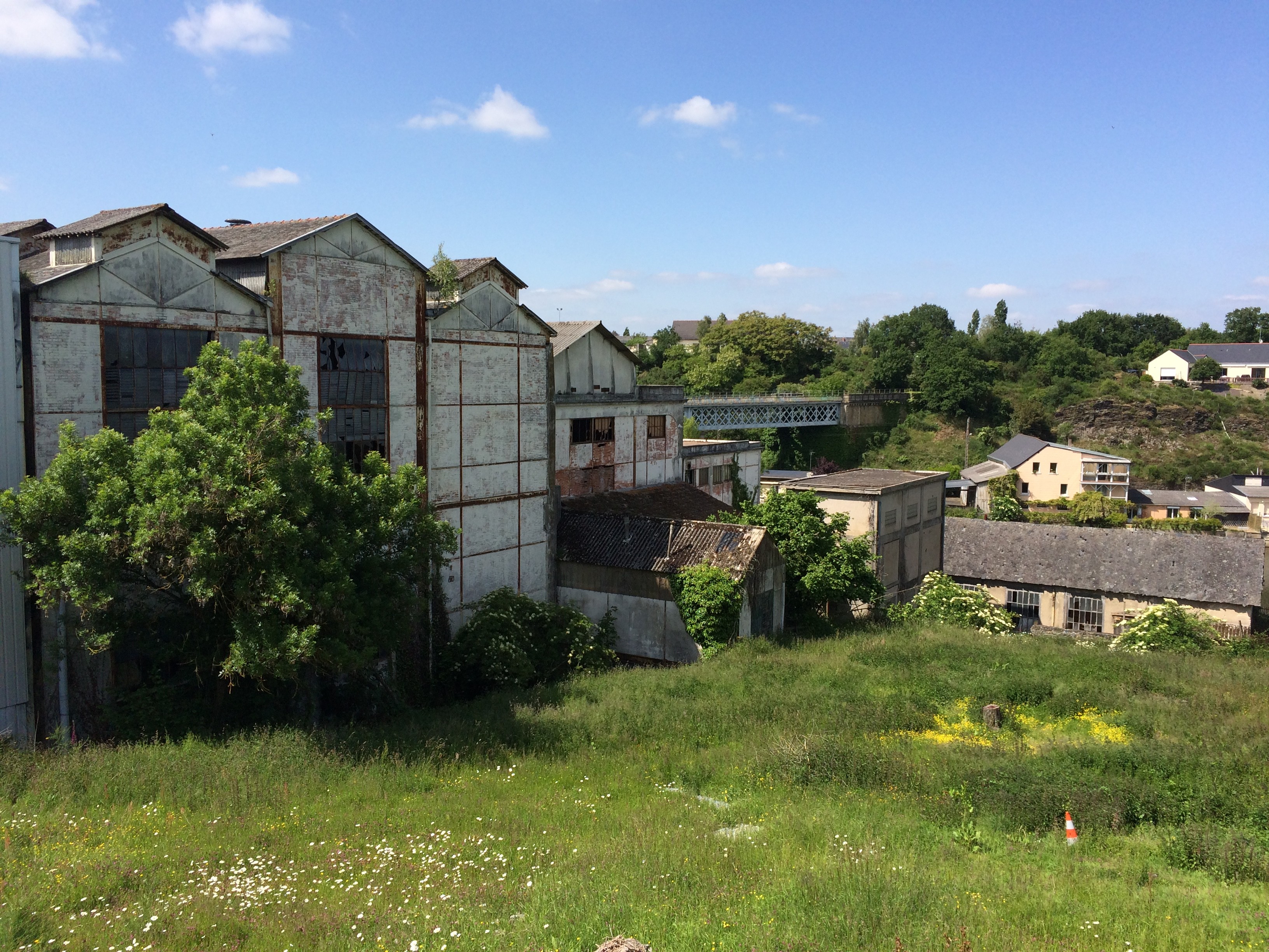
2. The Authion foundry - the wasteland nobody wants to clean up (Les Ponts-de-Ce)
Seven kilometres south of Angers, on the quai de l'Authion at Les Ponts-de-Ce, an aluminium foundry of nearly 13.5 hectares sprawls in the flood zone between the Loire and the Authion. The plant cast parts for the car industry for decades before it fell: court-ordered liquidation on 19 January 2009, 89 redundancies. Since then the site has been abandoned and vandalised, and above all heavily polluted - a study recorded around 15,500 tonnes of foundry sand, hydrocarbons and arsenic in the groundwater. A pollution nobody wants to pay to clean up.
It is precisely this pollution that explains the frozen time: no developer dares to take on the land. The buildings were even put up for auction in May 2024, proof that they were still standing and unsold - no redevelopment in sight. So this is a real industrial wasteland, the opposite of the fictional "urbex" sites resold with no identity. Sources: Fonderie & PIWI and the local press.
Private property, in a polluted zone: the interior is not accessible and the pollution (foundry sand, hydrocarbons, arsenic) makes the place objectively dangerous to health. The point below targets the centroid of the site footprint, from the ICPE perimeter in the Georisques/CASIAS database (the polluted-site record of the former foundry), cross-checked with the company-registry addresses (Fonderies de l'Authion / Helveticast, 10-30 quai de l'Authion). To be documented from the outside, respecting the perimeter.
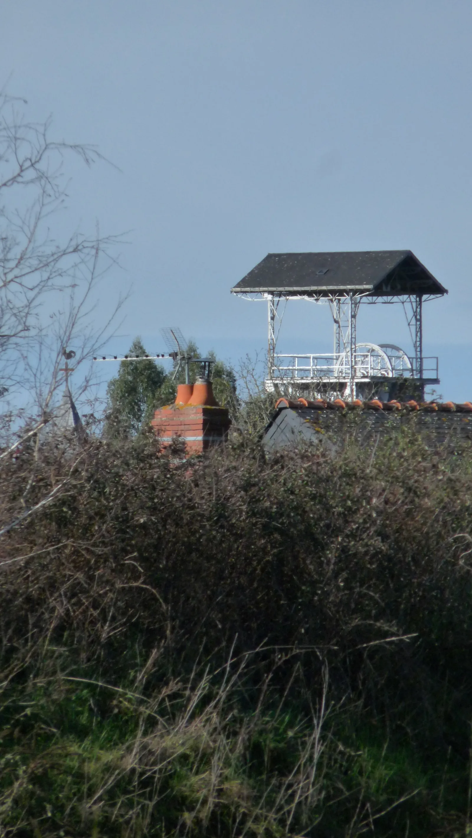
3. The former power station - the 1914 plant on the banks of the Oudon (Segre-en-Anjou Bleu)
About thirty kilometres north-west of Angers, in Segre-en-Anjou Bleu, a large brick building lines the Oudon along rue David-d'Angers. It is the former power station of the Societe de distribution d'electricite de l'Ouest, built between 1914 and 1917, whose premises Paulstra (rubber parts) occupied from 1959 to 1974 before moving to the industrial estate. The plant has been derelict ever since. Sources: Patrimoine du Haut-Anjou and the Merimee notice IA49001374.
The building holds a strategic position: on the axis towards Angers at the edge of town, its lower part running along the Oudon, near the Maingue lock. A more recent section burned down in the 2000s, but the large older part still stands, derelict. For the record, in honesty: in 2022-2024 the local authority funded a simple rehabilitation study (Petites Villes de Demain programme) - no demolition, no rehabilitation undertaken to date, but a status that could change.
Private property: access is not authorised and the partly burned building carries the usual risks of a wasteland (floors, weakened roof structure). The point below targets the ruined industrial building itself (footprint mapped in OpenStreetMap, building=industrial / ruins=yes), on rue David-d'Angers by the Oudon, ~230 m upstream of the Maingue lock - not to be confused with the still-active Paulstra plant on the industrial estate ~1.2 km to the north. A fine witness to the electrification of Haut-Anjou, to be photographed from the towpath.
4. Chateau de Grandfond - the neo-Gothic manor that was never lived in (Bellevigne-les-Chateaux)

For anyone willing to drive south of Saumur, in Breze (now part of Bellevigne-les-Chateaux), the Chateau de Grandfond is the archetypal forgotten chateau. Built between 1890 and 1893 by the Couscher family in a neo-Gothic style, it has the peculiarity of never having been lived in by its builders. A women's police school during the Second World War, then a holiday camp in the 1950s-60s, it was the subject of an aborted luxury hotel project - roof and joinery partly redone, then everything was left to ruin.
Today the Breze town hall page describes it bluntly: it "is letting itself be devoured by vegetation and looting". So it is a genuinely dilapidated, looted and overgrown private chateau - not a museum, not a restored site. Still worth noting: the Breze Patrimoine association ran its first guided tours during the 2024 Heritage Days, a sign of budding heritage interest. The status could change, but for now the manor remains a ruin.
Private property, not open to the public outside exceptional supervised tours: free access is not authorised. Standard risks of a large abandoned building: sagging floors, falling stone, roof structure weakened by looting. Grandfond is probably the most photogenic spot in this guide - one to see before the budding heritage interest closes it. Find every spot in the area on the Maine-et-Loire map.
FAQ - Urbex Angers
Is urbex legal in Angers?
Urban exploration is not illegal in itself, but entering private property without permission is trespassing (article 226-4 of the French Penal Code). Most Angers spots are private: we document them for their history, without ever encouraging break-ins. For more, read our guide is urbex legal in France.
Where can I find other abandoned places around Angers?
Our map lists thousands of spots across Maine-et-Loire and the neighbouring departments of the Pays de la Loire. You can add the four places in this article to your personal map for free via the button under each entry, then unlock the rest through our regional packs.
Why are there few spots in the heart of Angers itself?
Because the area is heavily "cleaned up": many of the flagship Angers wastelands have been demolished or are under redevelopment. Rather than selling you renovated sites, we widen the radius (Trelaze, Les Ponts-de-Ce, Segre, south of Saumur) to keep only places that are genuinely abandoned and verified. Our urbex gear guide helps you prepare these outings safely.
Are the coordinates in this article precise?
All four points are precise: the Trelaze slate mines and the Chateau de Grandfond are geolocated to the site, the Authion foundry is set on the Georisques ICPE perimeter (10-30 quai de l'Authion), and the Segre power station is pinned on the ruined building mapped in OpenStreetMap (rue David-d'Angers). Each coordinate is cross-checked against at least two sources.
Conclusion: Angers, the land of slate and forgotten wastelands
From the headframes of Trelaze to the banks of the Loire at Les Ponts-de-Ce, from the Segre power station to the Chateau de Grandfond, Angers urbex tells a century of history: the exhaustion of the slate mines, the fall of the foundries, the electrification of Haut-Anjou and dreams of stone never completed. These places are not stage sets: they are open-air history books, fragile, to be explored with respect and without damage. Add them to your map, and carry on your exploration with our top 10 abandoned places in Auvergne or the free urbex map.