Antenna walls as tall as apartment blocks, gutted radomes, bunkers drowning in graffiti, sea forts rusting on their stilts: the abandoned military base is one of the most powerful subjects in urbex. From the giant Duga radar, looming over the radioactive forest of Chernobyl, to the NSA listening station that towers over Berlin, all the way to the "concrete battleship" planted in Manila Bay, here are 10 military bases genuinely abandoned and still standing in 2026, ranked by sheer impact and historical weight.
Our map lists more than 229,000 geolocated abandoned places across more than 200 countries. We've filtered them down to keep only military sites that are truly abandoned and still standing in 2026, never demolished or turned into housing. For each one, its story, its video, and an "Add to my map" button: the exact GPS coordinate is free, no credit card needed. Forgotten bunkers, ghost barracks, dead radars, Atlantic Wall batteries: a whole vocabulary of the Cold War and the two world wars left to the silence.
Abandoned military bases: why Urbex Maps changes the game
Plenty of "free" sites still make you pay for the real address. We do the opposite: an "Add to my map" button unlocks the exact coordinate in your personal space, no credit card. A community of more than 40,000 explorers since 2021 checks every coordinate at least twice. The 10 bases below are ranked by visual impact and historical importance: we open with the Duga radar and close on Fort Ord and its huge American story. For each one, a link to its page and to the map of its country. Everything opens from the free urbex map or your My map space.
The 10 abandoned military bases at a glance
| Place | Country | Type | Access in 2026 |
|---|---|---|---|
| Duga (Chernobyl-2) | Ukraine | Over-the-horizon radar | Exclusion zone |
| Teufelsberg | Germany | NSA listening station | Paid visit |
| Maunsell Red Sands | United Kingdom | Anti-aircraft sea forts | At sea / off-limits |
| Fort Drum | Philippines | Armored fort | Island / by boat |
| Wünsdorf | Germany | Soviet headquarters | Guided tour |
| Orford Ness | United Kingdom | Nuclear weapons testing | Very restricted access |
| Ouvrage de Métrich | France | Maginot Line | Clandestine / backfilled |
| Batterie Todt | France | Atlantic Wall | Free (bunkers) |
| Hara | Estonia | Submarine base | Paid |
| Fort Ord | United States | Army camp | Partial / Superfund |
Why some famous military bases are not on this list
An honest list leaves out as much as it includes. The Balaklava submarine base (Crimea) has become a paid museum, and 2025 sources report its military reactivation by the Russian occupier: neither abandoned nor freely accessible. Vozrozhdeniya Island (Aralsk-7), a former Soviet biological weapons site on the Aral Sea, has had its last buildings demolished; only foundations remain. Krampnitz, near Potsdam, long an urbex shrine, is now a full-blown construction site: a new residential district opened there in 2025. The Longues-sur-Mer battery in Normandy is superb but listed and maintained, hence preserved and not abandoned. Finally Paldiski (Estonia), the Soviet nuclear submariners' training center, has had its flagship building razed and its reactors sealed under guard. None of them meets the "truly abandoned and standing" test. The ten that follow do.
1. Duga, Ukraine: the giant radar of Chernobyl
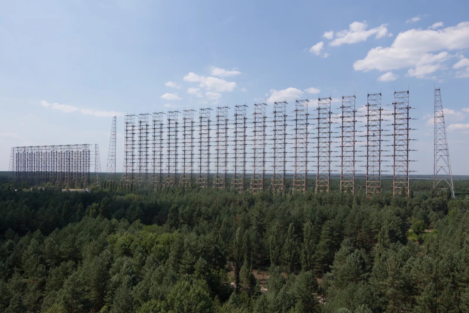
Nicknamed the "Russian Woodpecker" for the interference it spat across shortwave bands worldwide, Duga was a Soviet over-the-horizon early-warning radar for missile detection. Its receiver, an antenna wall nearly 150 meters long and 30 to 50 meters high, went into service in July 1976 and was declared operational until 1989. The Chernobyl disaster, in April 1986, contaminated the area and hastened its abandonment. Forty years on, the steel structure still holds, colossal, planted in the forest of the exclusion zone; you can spot it from kilometers away. Metal looting threatens it and dismantling plans are circulating, but it remains one of the most striking images of the Cold War. Guided tours of the zone have been suspended since 2022. More ruins on the Ukraine urbex map.
2. Teufelsberg, Germany: the NSA listening station

Teufelsberg, the "Devil's Mountain," is an artificial hill made of 12 million cubic meters of World War II rubble, piled over an unfinished Nazi military academy. From 1963, the NSA built one of its largest listening stations there, as part of the ECHELON network, to intercept Eastern Bloc communications over the Wall. Beneath its distinctive white domes, antennas picked up Soviet radio traffic until the end of the Cold War. Abandoned in the early 1990s, the station was taken over by street artists: its torn-open radomes, draped in shredded tarps that snap in the wind, loom over the Grunewald forest. The site, fenced off and privatized, now opens as a paid visit and urban-art gallery. More places on the Germany urbex map.
3. Maunsell Red Sands, United Kingdom: the sea forts of the Thames
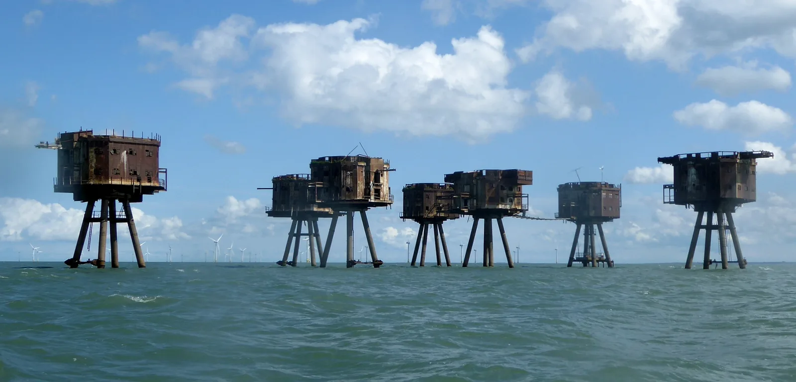
Standing on the water like wading war machines, the Red Sands forts are anti-aircraft forts built in 1942 to designs by engineer Guy Maunsell, to defend the Thames estuary against the Luftwaffe and mine-layers. Each "army" fort gathers seven towers on stilts linked by walkways: five gun towers, a searchlight tower, a control post. Decommissioned in the mid-1950s, the forts were then squatted by pirate radio stations in the 1960s, before being left to rust out at sea. Declared dangerous after a 2021 inspection, their seven towers still stand, bristling with twisted ladders; no public landing is allowed, and you can only approach them by boat. The rest of the country on the United Kingdom urbex map.
4. Fort Drum, Philippines: the concrete battleship of Manila
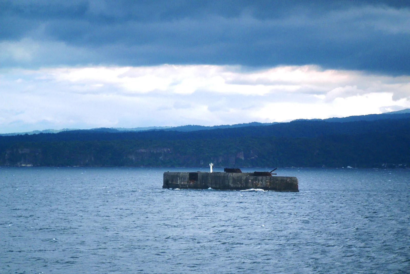
At the southern entrance to Manila Bay, Fort Drum looks like no other fort: it is a genuine concrete battleship. Between 1909 and 1914, the U.S. Army leveled the islet of El Fraile and cast it in reinforced concrete in the shape of a warship, about 110 meters long, bristling with battleship turrets. Captured by the Japanese in 1942, it was retaken in April 1945 by brutal means: American forces pumped a mixture of gasoline and TNT inside before setting it ablaze, killing the Japanese garrison and putting it permanently out of action. Decommissioned after the war, it was never occupied again, except by an automatic navigation light set on its deck. A gray, silent hull, it can only be reached by boat. The Philippines urbex map shows more.
5. Wünsdorf, Germany: the Soviet forbidden city
South of Berlin, Wünsdorf was nicknamed the "forbidden city": the headquarters of the Soviet forces in East Germany, a closed town where up to 75,000 soldiers and their families lived, with its own daily train to Moscow. A German military site since 1906, it had housed the army high command (OKH) from 1935, with vast underground communications bunkers. Taken by the Red Army in 1945, it became the heart of the Soviet presence in East Germany until the withdrawal of 1994. Since then, the military core has been left to rot: the monumental House of Officers empties out, a four-meter statue of Lenin still watches over a deserted square, and the Maybach bunkers sleep in the forest. You can only enter on a guided tour. More ruins on the Germany urbex map.
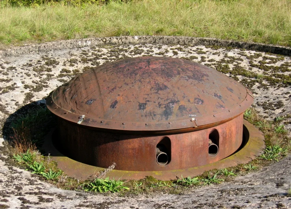
6. Orford Ness, United Kingdom: the pagodas of the atomic bomb
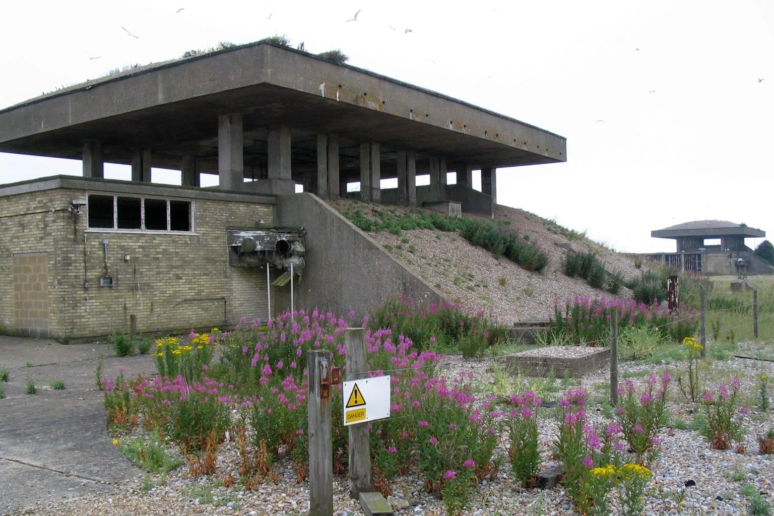
On a long shingle spit in Suffolk, cut off from the world, Orford Ness was a military test range from 1913, where ballistics and radar were developed. But its strangest structures are the "pagodas": between 1953 and 1966, the AWRE, Britain's Atomic Weapons Research Establishment, built test cells there with massive roofs set on columns, designed to collapse and contain an explosion in case of an accident during environmental testing of nuclear warheads (vibration, heat, with no fissile charge). The tests stopped in the late 1960s. The National Trust now lets the site decay slowly, in a "managed ruin" style; the pagodas, still standing but judged dangerous, can only be visited in a trickle. The country on the United Kingdom urbex map.
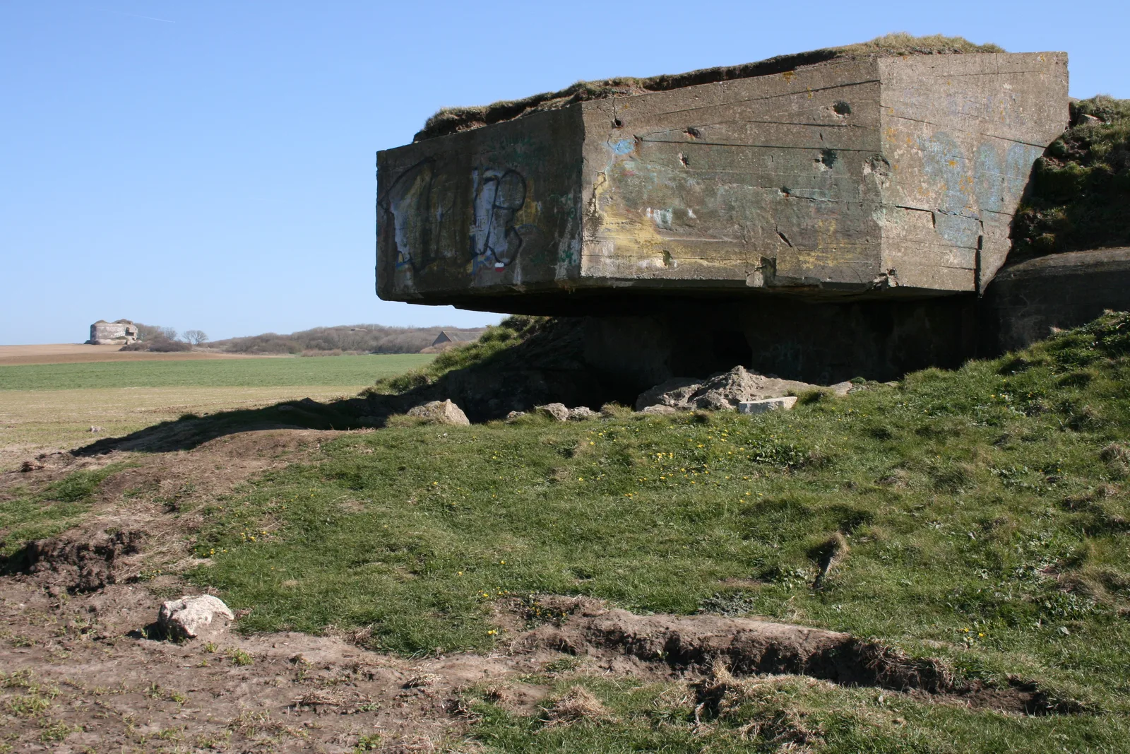
7. Ouvrage de Métrich, France: the forgotten giant of the Maginot Line
At Kœnigsmacker, in the Moselle, the Ouvrage de Métrich is the third-largest fort of the Maginot Line, behind the Hackenberg and the Hochwald. Built around 1931-1935 to cover Thionville against an invasion from the east, it is an underground monster: combat blocks with 75 and 135 mm turrets, observation cloches, linked by deep galleries running with railway tracks. Disarmed after the war, it was never turned into a museum like its guarded neighbors: it is officially classified as "abandoned". Looted by scrap dealers, vandalized, eaten away by a gypsum soil that destroys slabs and walls, it crumbles in silence; the army has backfilled some entrances and gun blocks. You can only go down clandestinely, and it's dangerous. The France urbex map lists many more.
8. Batterie Todt, France: the giant gun of the Atlantic Wall
At Cap Gris-Nez, facing England, the Batterie Todt was one of the centerpieces of the Atlantic Wall. Built from 1940 to 1942, it lined up four 380 mm Krupp guns with a range of about 55 kilometers: enough to reach the English coast and lock down the Strait of Dover. First named "Batterie Siegfried," it was renamed in honor of Fritz Todt, head of the Organisation Todt. Neutralized in September 1944, it was then largely abandoned, its near-indestructible concrete left in place. Of its four casemates, only one became a museum; the others, lost in the woods, flooded and lined with graffiti, are left to explorers, freely accessible but dangerous. Discover the rest on the France urbex map.
9. Hara, Estonia: the Soviet submarine base
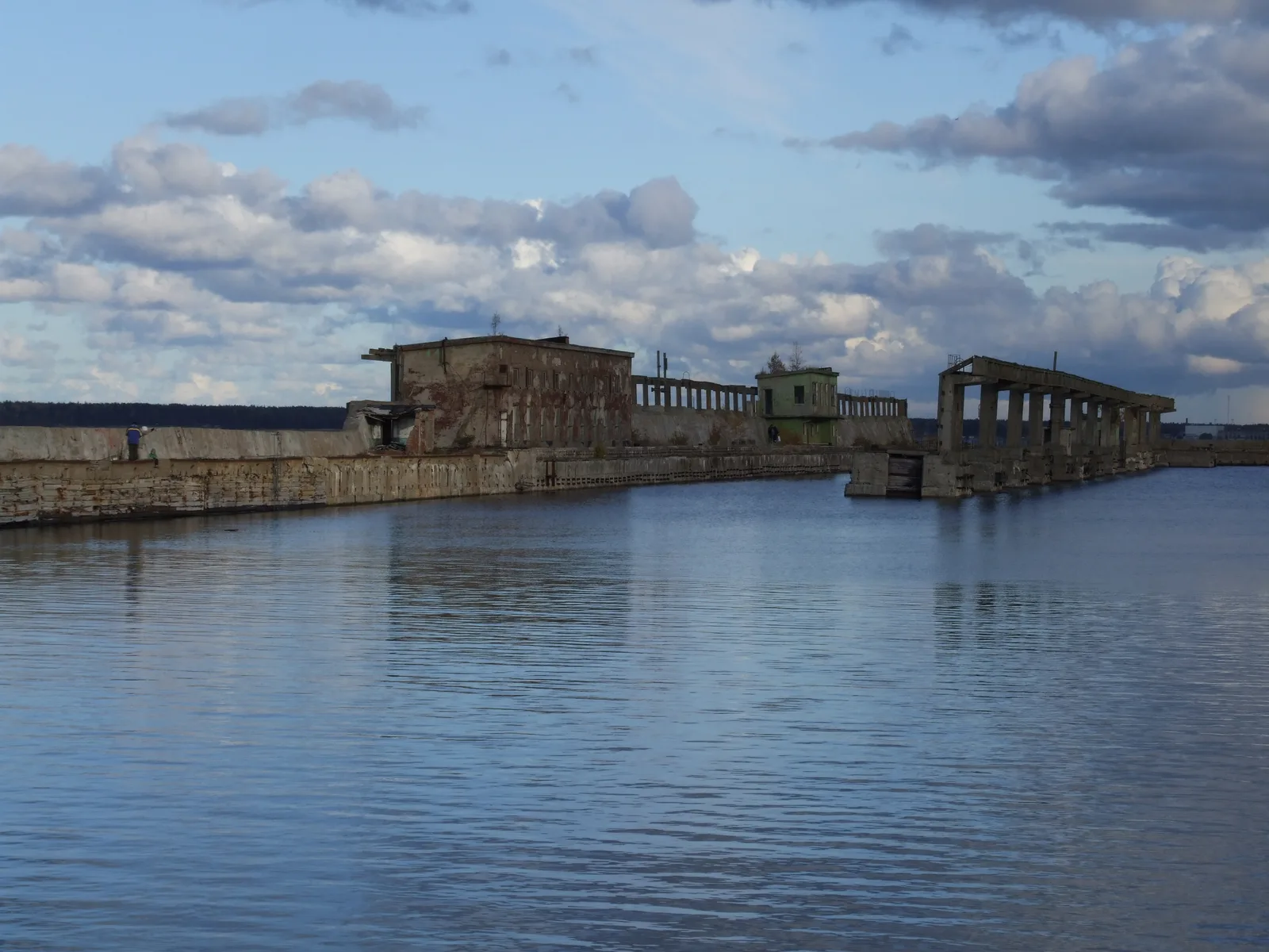
In Lahemaa National Park, on the Baltic shore, Hara hides one of the most secret bases of the USSR: a submarine degaussing station. Established in the 1950s, it was used to neutralize the magnetic signature of hulls to make them invisible to mines. Large concrete structures were built around 1956-1958, including a long degaussing pier that juts out into the sea. The base operated until the collapse of the USSR in 1991, abandoned so quickly that only foundations and this ghost pier remain. A recognized urbex spot, the pier still holds, even as the site decays: in August 2024, the collapse of a hall was a reminder that it is no frozen museum. Access is now paid. More spots on the Estonia urbex map.
10. Fort Ord, United States: the giant camp of Monterey Bay
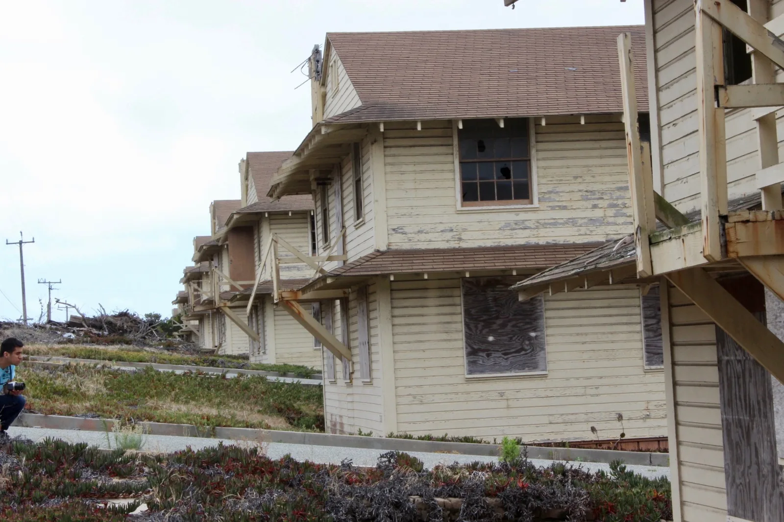
We finish in California, on the Monterey Bay coast, where Fort Ord spread across 28,000 acres: one of the largest U.S. Army camps on the West Coast. From World War II to the Gulf War, it trained hundreds of thousands of soldiers; up to 35,000 people lived there. The 1993 closure (BRAC program) stopped it dead. Thirty years later, entire streets of two-story barracks still stand, windows shattered, walls tagged, slowly swallowed by coastal vegetation. The real obstacle to any redevelopment is pollution: Fort Ord is a "Superfund" site, riddled with unexploded ordnance and contaminated soil, with whole sectors fenced off. To go further, read our dedicated piece on abandoned military bases in the United States, and explore the United States urbex map.
FAQ - Abandoned military bases
What is the most impressive abandoned military base in the world?
For sheer scale, the Duga radar of Chernobyl is hard to beat: a steel antenna wall nearly 150 meters long. Berlin's Teufelsberg, with its NSA radomes, and Fort Drum, the "concrete battleship" of Manila Bay, are also among the most spectacular. All three feature in our top 10 with their free GPS coordinates.
Is it legal to explore an abandoned military base?
It depends on the site. Some have become accessible on a paid or guided visit (Teufelsberg, Wünsdorf, Hara). Others remain strictly off-limits: the exclusion zone for Duga, active military land, polluted "Superfund" sites like Fort Ord. Many former bases still hold unexploded ordnance. Always check the current access rules before you set off, and never break a ban that puts you in danger.
Are these abandoned military bases dangerous?
Yes, more than the average abandoned place. The risks specific to the military add to those of ruins: unexploded ordnance on old firing ranges and batteries, chemical contamination (Fort Ord), radioactivity (Duga), underground galleries with foul air and weakened structures (Maginot). Never explore alone, and turn back if the structure looks unstable.
Why are there so many abandoned military bases?
The geography of military abandonment tells the story of the 20th century: coastal forts from the two world wars rendered useless, a huge Cold War apparatus (radars, listening stations, missile bases) made obsolete, then the Soviet withdrawal of 1991-1994 that emptied hundreds of garrisons across Eastern Europe overnight. In the United States, the BRAC program closed hundreds of bases. Hence these ruins all over the world.
Where to find more free abandoned bases?
Our free urbex map lists more than 229,000 abandoned places across more than 200 countries, bunkers and military bases included. Every free spot unlocks without a credit card in your My map space. For the United States, see also our piece on abandoned American military bases.
Conclusion: the Cold War left to silence
From the forests of Chernobyl to the cliffs of the Pas-de-Calais, these ten bases tell a century of wars and tensions: coastal forts outpaced by aircraft, Cold War concrete giants struck dumb by the fall of the Wall, Soviet garrisons emptied in a matter of months. What remains are immense silhouettes, radars, casemates, piers and barracks, slowly reclaimed by silence and vegetation. Explore with caution and respect, watch out for unexploded ordnance and polluted soil, never break a ban that puts you in danger, and open the free urbex map to find these bases and 229,000 other abandoned places.