An 18th century church spire rising out of a turquoise lake of sludge. Imperial baths where Empress Sissi once bathed, their roofs now caved in. A village of Bohemian settlers whose last inhabitant died in 1998. A billion-dollar power plant that ran for less than a year. Romania is, without exaggeration, one of the most spectacular countries in Europe for abandoned places, and this guide is the definitive starting point: we picked 10 places still standing in 2026, from Băile Herculane to the docks of Brăila. No ticketed museums, no restoration sites, just real ruins, documented and geolocated, ranked by visual power and historical weight.
Our map gathers over 233,000 geolocated spots across 200+ countries, including more than 1,100 geolocated abandoned places in Romania: abandoned buildings, factories, sanatoriums, manor houses, depopulated villages and the whole spectrum of derelict places that make urbex in Romania such a special playground, including a few so-called haunted places, if you believe the legends. Under every place in this top you will find an "Add to my map" button that unlocks the exact GPS coordinates, free, no credit card required. And if you want to dig deeper city by city, we have dedicated guides: Bucharest, Cluj-Napoca, Timișoara, Iași and Constanța. Everything starts from the map of abandoned places in Romania.
Free urbex in Romania: why Urbex Maps changes the game
You already know the script: a website promises "free abandoned places", then sends you to a forum where the real coordinates are sold one by one. We do the exact opposite. You hit "Add to my map" and the exact coordinates land in your personal space, no credit card required. Behind it stands a community of over 40,000 explorers active since 2021, and every published coordinate is verified at least twice, by the contributor and by a regional moderator. The free spots coexist with the paid packs, which fund precisely that verification work. The 10 places below are ranked by visual power and historical importance: we open with the Neptun Baths, the undisputed star of Romania's ruins, and close with a world first in reinforced concrete, Saligny's silos in Brăila. The house rule is the same everywhere: we do not encourage breaking in, take only photos, leave only footprints. Browse the free urbex map or start straight from your personal map.
The top 10 abandoned places in Romania at a glance
| Place | County/Area | Type | Access 2026 |
|---|---|---|---|
| Neptun Baths | Caraș-Severin (Băile Herculane) | Imperial baths | Interior sealed off, exterior open |
| Geamăna | Alba (Roșia Poieni) | Village swallowed by a tailings pond | Open, but stay away from the sludge |
| Marila Sanatorium | Caraș-Severin (Oravița) | Pulmonary sanatorium | Partly occupied, be careful |
| Lindenfeld | Caraș-Severin (Semenic) | Ghost village | Open, 9 km of forest road |
| Călimani sulfur quarry | Suceava (Călimani National Park) | Mining site at 1700-1900 m | Free hiking, park rules apply |
| Central Baths Pavilion | Vâlcea (Băile Govora) | Spa pavilion | Closed, private property, discretion |
| Anina Power Plant | Caraș-Severin (Crivina) | Oil shale power plant | Open, semi-inhabited colony next door |
| Călan Iron Works | Hunedoara | Steel complex | Open brownfield of ~50 ha |
| Govăjdia Blast Furnace | Hunedoara (Ghelari) | Blast furnace from 1810 | Free entry |
| Anghel Saligny Silos | Brăila | Port silos from 1888 | Active port area, check on site |
Why they are NOT on the list: famous places that are no longer abandoned
Lists copied around the internet still recommend, in 2026, places that no longer exist or have not been abandoned for years. We checked every single one, and a few big names failed the test. The Constanța Casino reopened on 21 May 2025 after a 37 million euro restoration: it is gorgeous, but it is not urbex anymore. The Petrila Mine was turned into a museum through the "Planeta Petrila" project funded by the PNRR and is visited with a ticket and a guide. Bánffy Castle in Bonțida is being restored step by step by Transylvania Trust and hosts the Electric Castle festival, so no deserted ruin there either.
Three more dated exclusions, so you do not waste the trip: the Doicești power plant was demolished in 2025 to make room for the country's first SMR modular reactors, the Little Trianon in Florești has been a restoration site since November 2025, and the Vatra Dornei Casino has been operating as a museum since 2023. This exact filter is what separates a top written from a desk from one built on a map with over 1,100 verified places in Romania. What follows below is only what is truly worth the trip in 2026.
1. The Neptun Baths (Băile Herculane): the empire's thermal cathedral
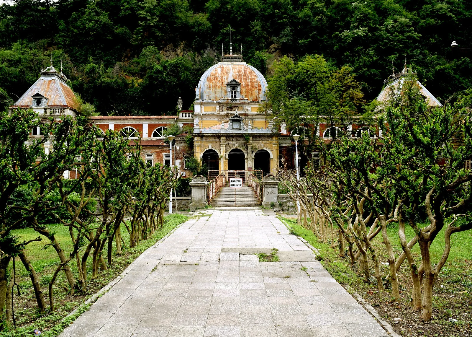
If Romania has a "queen of ruins", she stands on the banks of the Cerna. The Neptun Baths were built between 1883 and 1886 to the plans of architect Ignác Alpár, at the height of the golden age of Băile Herculane, when the Viennese elite came down here by direct train from Budapest. Behind the imperial facade stretched 32 treatment cabins and pools clad in red marble, visited by crowned heads, Empress Sissi first among them. In its day, it was one of the most modern bathing establishments in Central Europe. After 1990, botched privatizations closed the pavilion's doors and the water got to work: the roofs gave in, the stucco falls off piece by piece, and the ownership lawsuit sat blocked for years at the High Court of Cassation and Justice.
Since 2019, the volunteers of Herculane Project have secured the baths and rebuilt sections of the roof, and in 2022 Europa Nostra put the complex on its "7 Most Endangered" list of European heritage at risk. That does not change the numbers though: a full restoration needs around 12 million euros that nobody has, so the interior remains sealed off and closed to visitors. The good news for you: the exterior is free to explore, and the promenade between the Neptun Baths, the cast iron bridge and the surrounding abandoned Belle Époque hotels is probably the densest urbex walk in the country. Do not force the doors: the building is a listed monument, and the volunteers keeping it alive deserve respect. You have days of work around it: the map of the Băile Herculane area is part of the 16 geolocated spots in Caraș-Severin.
2. Geamăna: the village swallowed by the Roșia Poieni tailings pond
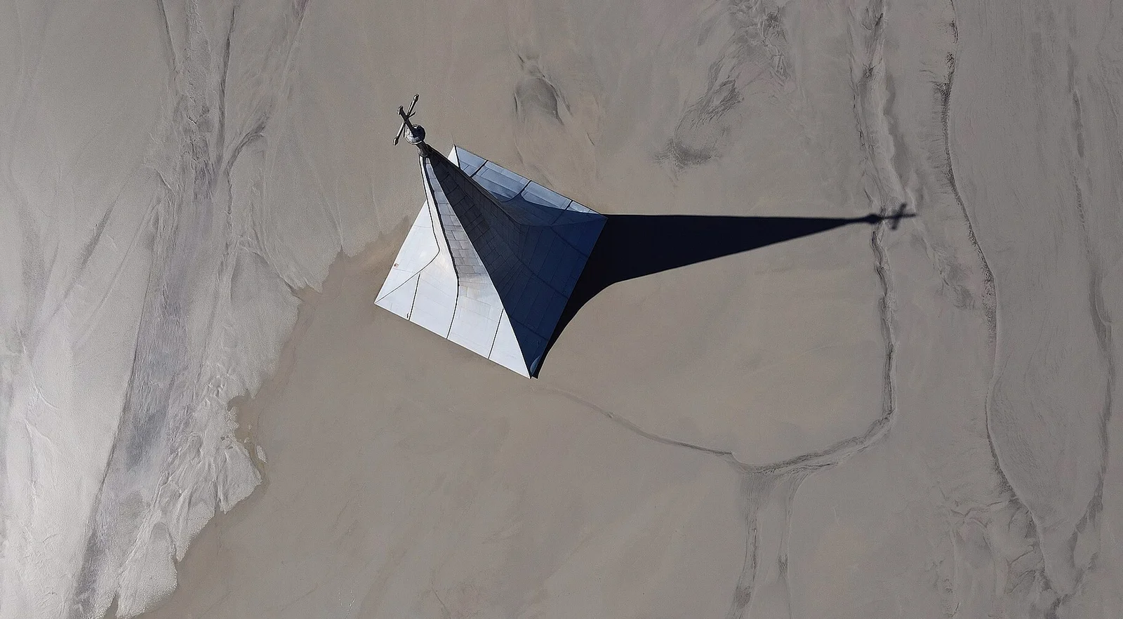
The image that pushed Romanian urbex into the international press comes from the Apuseni mountains: an 18th century church spire rising from a lake of sludge in unreal shades of turquoise and orange. In 1978, Ceaușescu decided that the valley of the village of Geamăna would become the tailings pond of the Roșia Poieni copper mine. More than 1,000 people were driven out of their homes with promises of compensation and relocation that, for the most part, were never honored. The houses, the school, the cemetery and the church stayed behind, and the industrial slurry covered them meter by meter for four decades. What you see today is not a frozen backdrop but a slow-motion disaster, still in motion.
Because yes, the pond is active: the Roșia Poieni mine, operated by CupruMin, keeps discharging into it, and the sludge level rises by roughly one meter per year. The spire that still dominated the valley in the 2000s is now almost level with the surface, so the window in which you can still photograph the scene is closing before your eyes. There is only one golden rule here: do not go near the sludge. The crust looks solid, but it is unstable and toxic, with tens of meters of sediment underneath. Access is free on the road climbing up from Lupșa, and the viewpoints on the slopes give you the classic shot at zero risk. Geamăna is two hours from Cluj, so you can easily pair it with our urbex Cluj-Napoca guide or with the rest of the Romania map.
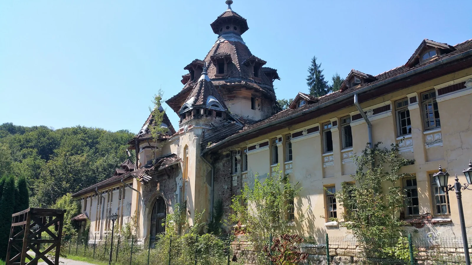
3. The Marila Sanatorium (Oravița): the tuberculosis colossus at 600 meters
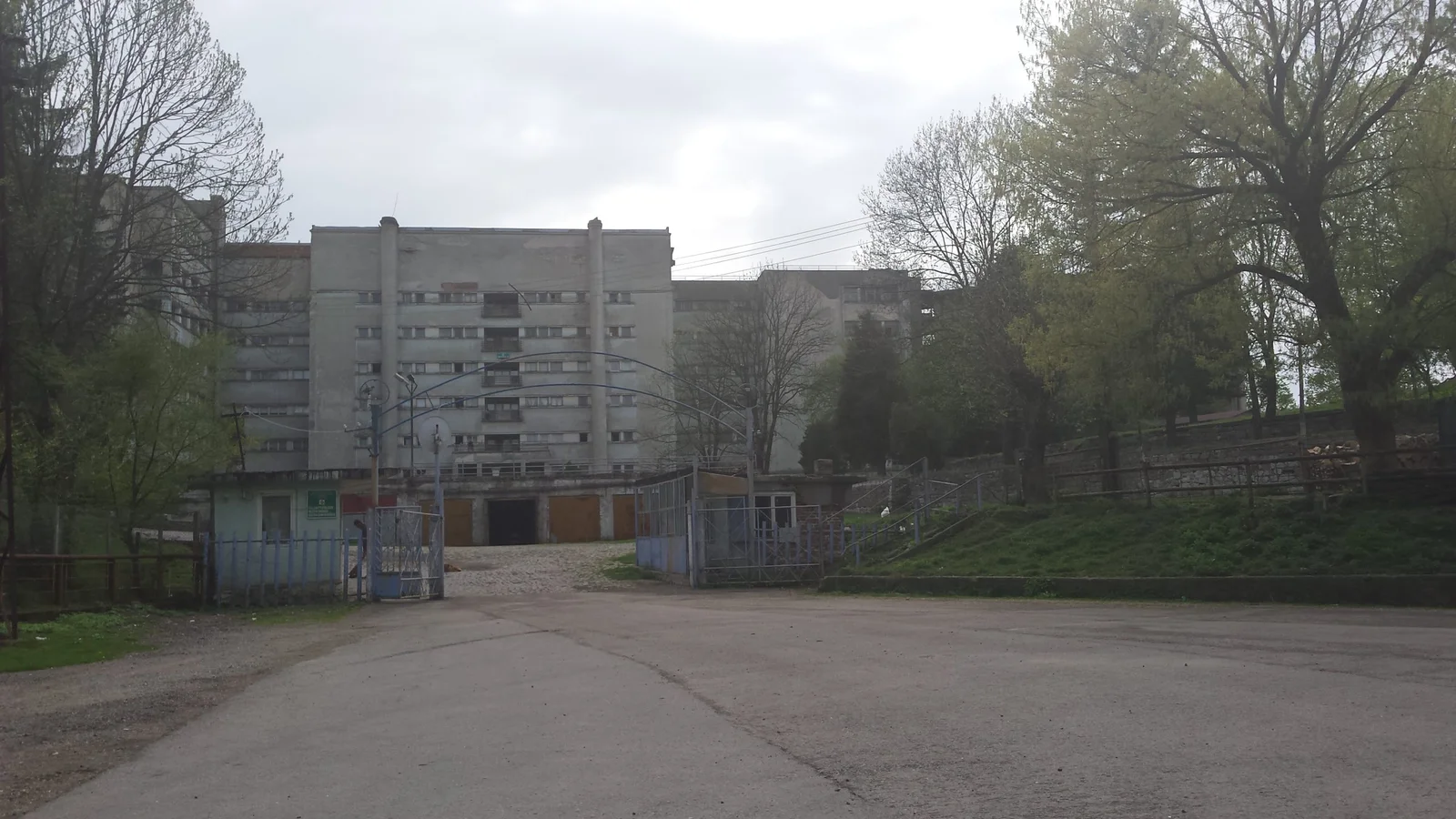
High up in the forests above Oravița, at 600 meters of altitude, the clean conifer air was once a medicine. On it was built the Marila Sanatorium, one of the largest pulmonary sanatoriums in southeastern Europe, with over 600 beds at its peak. The clientele initially came from all over Austria-Hungary: tuberculosis did not care about rank, and the altitude cure was the only hope before antibiotics. The main pavilion, a massive block with cure terraces facing the valley, worked as a pneumology hospital until recent times, decaying year after year, with entire wards closed for lack of money. The breaking point came when a roof collapse forced the emergency evacuation of more than 60 patients, a hard image to believe for a European hospital of the 2020s.
At the end of 2024, around 20 million euros were promised for rehabilitation, but in 2025 only the paperwork existed: on site, not a single crane, just fallen plaster and empty corridors. For you, that means an explorable colossus, with one important nuance: part of the complex may still be occupied, with residual medical or security activity. Aim for the big disused pavilion, do not wander through areas showing signs of use, and walk away without arguing if you are asked to. The cure halls with their rows of broken windows, the monumental staircase and the terraces peeling away from the facade make Marila the most atmospheric abandoned sanatorium in the country. The rest of the Banat mining valley is waiting for you on the map of abandoned places in Romania.
4. Lindenfeld: the settlers' village where the last man died in 1998
In 1828, 36 families of Bohemian settlers, the Pems, as they were called in the Banat, climbed to 760 meters on the slopes of the Semenic and founded Lindenfeld, "the field of linden trees". For a century and a half they lived there from cattle and orchards, with a Catholic church, a school and a cemetery with German crosses. Then history ground them down one by one: industrialization pulled the young to Reșița and Caransebeș, and emigration to Germany emptied the houses one after another. In 1998 died Paul Schwirzenbeck, the last inhabitant, the man who had refused to the very end to leave his village. Since then, Lindenfeld has been Romania's ghost village par excellence, a place where rural depopulation is physically visible, house by house.
Exploring it is a lesson in recent archaeology: collapsed houses with the furniture still inside, stoves, beds and wardrobes rotting under fallen beams, the German cemetery with Gothic inscriptions and the church whose roof was rebuilt by volunteers so the village would not vanish completely. There is no paved road, no electricity, no reliable signal: from Poiana, in the commune of Buchin, you have 9 kilometers of forest road to cover on foot, by bike or with a high-clearance car. That very isolation saved it from vandalism, so make sure it stays that way: access is free, but everything there belongs to a memory that cannot be rebuilt. Lindenfeld connects naturally to the rest of the abandoned Banat, from Herculane to Anina, on the country map.
5. The Călimani sulfur quarry: a lunar landscape at 1800 meters
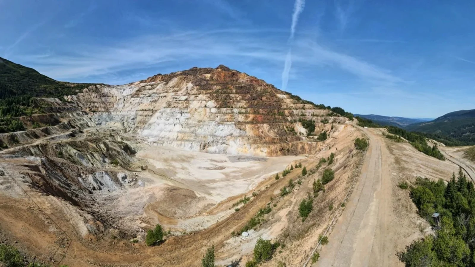
Between 1969 and 1997, the heart of the Călimani mountains hosted the highest mining operation in Romania: the sulfur quarry at 1700-1900 meters of altitude, which quite literally gutted Negoiul Românesc peak. Communism needed sulfur for its chemical industry, so an entire mountain was decapitated, terraced and excavated, with a flotation plant, a workers' colony and industrial roads cut through the alpine zone. The yield was always miserable, and after 1989 the mine agonized until its final closure. Left behind are an artificial crater visible from every ridge around and 180-200 hectares of waste heaps, tailings in colors from sulfurous yellow to ash gray, which vegetation is only now starting to reclaim.
The state started the environmental cleanup but stopped it at roughly 80%, stuck in a land dispute tied to government decision HG 644/2007, so the site was left in a hybrid state: neither a mine nor a healed mountain. For an explorer, that is a gift: the ruins of the flotation station, the industrial platforms and the quarry's switchbacks make up the closest thing to a lunar landscape you will find in the Carpathians. It is all visited on foot, as a free hike through the Călimani National Park, with a single condition: respect the park rules, stay on the trails and do not camp on the tailings. It is the only place in this top where urbex is done with hiking boots and a ridge map. Other former mining sites await on the map of abandoned places in Romania.
6. The Central Baths Pavilion (Băile Govora): elegance rotting in the middle of the resort
In Băile Govora, two twin buildings tell the story of two destinies. Both bear the signature of architect Ernest Doneaud: the Palace Hotel, restored and full of spa guests, and, just 240 meters to the south, the Central Baths Pavilion, built between 1911 and 1914 and opened in 1915, today an empty shell in the very center of the resort. In its good years, the pavilion was a luxury spa machine: 146 treatment cabins, hydrotherapy with sulfurous and iodine-rich waters, and from 1927 even an X-ray service, an absolute rarity for an interwar Romanian resort. Whoever stepped off the train at Govora came, in essence, for this building.
For about 20 years, its doors have been shut. Handed back to a private owner with no funds, the pavilion needs roughly 6 million euros that nobody has, so the columned halls and the treatment rooms decay in full view of the spa guests strolling through the park a few steps away. In March 2025, the squatters who had taken over the side wings were evicted, a sign that someone is still watching the building. For you, that translates simply: this is the most urban place in this top, so maximum discretion: you are in the middle of a working resort, with neighbors, local police and cameras. Photograph the facade at will, and weigh the risk twice before considering the interior. The Olt valley hides many other spa-era relics, all on the Romania map.
7. The Anina Power Plant (Crivina): a billion dollars buried in smoke
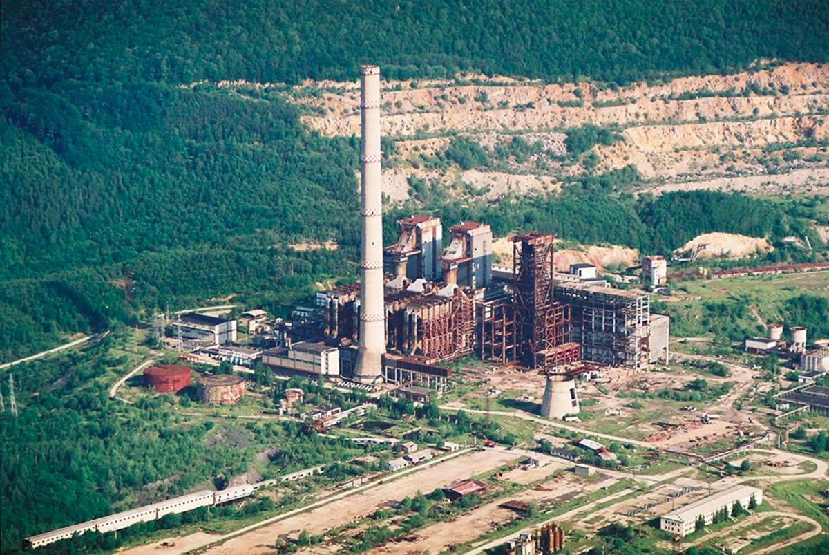
Of all the megalomanias of the "Golden Age", none burned more money for less result than the Anina power plant. The idea sounded revolutionary: Romania had mountains of oil shale in the Banat, so Ceaușescu ordered a power plant to burn it directly. Around one billion dollars was invested, an entire hillside was razed for the quarries, and an energy colossus with a 220 meter chimney rose at Crivina. The problem, flagged by engineers from the start: the shale does not burn efficiently, its calorific value is that of wet stone. Inaugurated in 1984, the plant ran for a total of about 8,400 hours, less than one cumulative year, sometimes consuming more energy than it produced.
The 220 meter chimney was dynamited in 2009, but what remains on the plateau is still overwhelming: two gigantic rusted boilers as tall as apartment blocks, the cooling towers and the conveyor gantries that nature swallows year after year. Next door survives the Crivina colony, the workers' quarter built for the plant that never really worked, today semi-inhabited by some 50 people: say hello, talk to them, the people there know everything. The scrap iron gets cut up sporadically, piece by piece, so the rule is simple: document it now, before the last boiler leaves for the smelter. Access to the plateau is free; the industrial terrain just demands serious boots and attention to openings. The whole mining Banat, from Anina to Oravița, is on the map of abandoned places in Romania.
8. The Călan Iron Works: the archetype of the factory town left without its factory
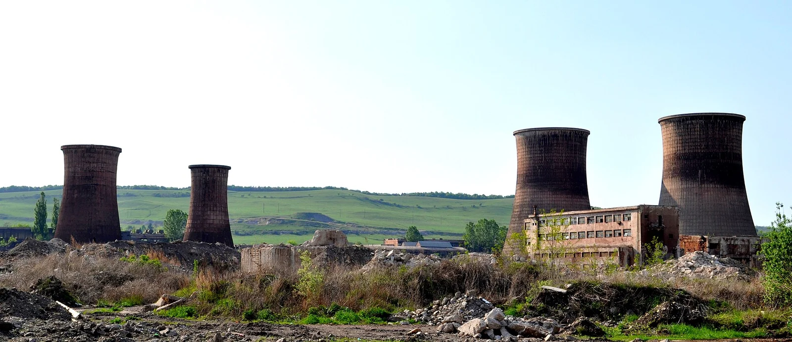
Călan is the place where you understand, in a single walk, what happened to Romanian industry. The first blast furnace was lit here in 1871, and by the end of the 19th century it was the largest in the country: an entire town grew around it, with a workers' colony, canteens and the workers' club, today a listed monument registered on the LMI heritage list under code HD-II-m-B-03282. The communist regime oversized everything: next to the old works rose the "Victoria" complex, which in the 1980s kept tens of thousands of people alive in the Strei valley. After 1989 the orders vanished, the complex was closed, then demolished and cut up for scrap almost entirely, leaving the factory town without its reason to exist.
What remains is an industrial brownfield of roughly 50 hectares, free to walk: foundations the size of public squares, shattered halls, loading ramps and vegetation quietly breaking through the concrete. It is not an urbex of spectacular interiors but of post-industrial landscape, the kind of place where evening light turns the ruin into a stage set. The town next to the brownfield lives on, its workers' blocks half emptied, which makes Călan the archetype of the Hunedoara mono-industrial town left without industry. It is also the best starting point for the next place in this top, the Govăjdia blast furnace, half an hour away through the land of the Pădureni. The whole Hunedoara steel basin is mapped on the map of abandoned places in Romania.
9. The Govăjdia blast furnace: the furnace that may have fed the Eiffel Tower
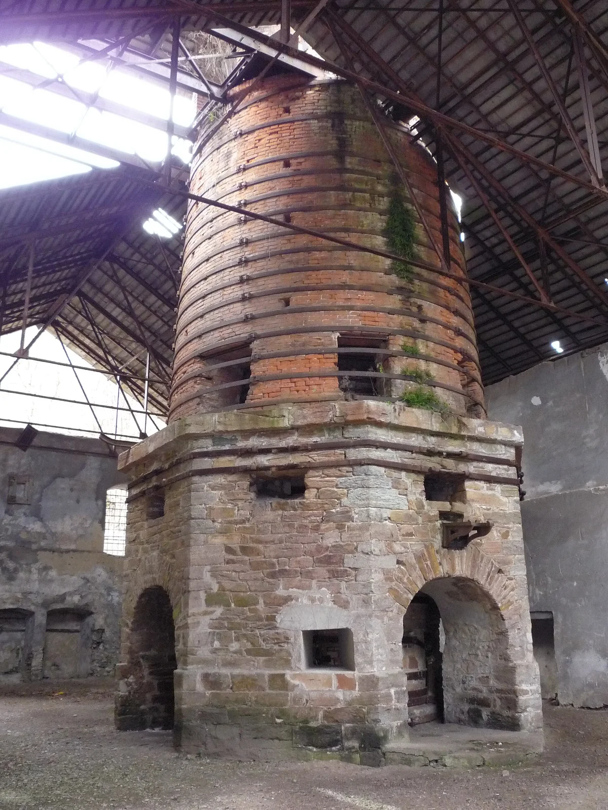
In a narrow valley in the land of the Pădureni, a few kilometers from the iron mines of Ghelari, hides a monument few countries would let die: the Govăjdia blast furnace, built between 1806 and 1810 and considered in its day among the most modern in Europe. Ore was smelted here for a century, and local tradition holds that Govăjdia cast iron made its way into the structure of the Eiffel Tower, a story impossible to prove definitively, but with the real kernel of Hunedoara's iron exports of that era. The furnace went out in 1918, together with the empire that had built it, and it has been waiting ever since. The narrow-gauge mining railway that linked Govăjdia to Hunedoara, a masterpiece with tunnels carved into the rock, is gone too, dismantled piece by piece.
Its state today is a barometer of Romania's industrial heritage: the roof partially collapsed in the 2023 floods, the building sits on the waiting list of the National Heritage Institute, and there is no funding. You walk in freely, between stone walls a meter thick, with the furnace's mouth open above you like a cathedral dome black with soot. It is the kind of place small in footprint but huge in historical density: 15 minutes of exploring, two centuries of industry. The classic combo is Călan, Govăjdia and Corvin Castle in a single day, with the rest of Hunedoara county on the map of abandoned places in Romania.
10. The Anghel Saligny silos (Brăila): a world first forgotten in the port
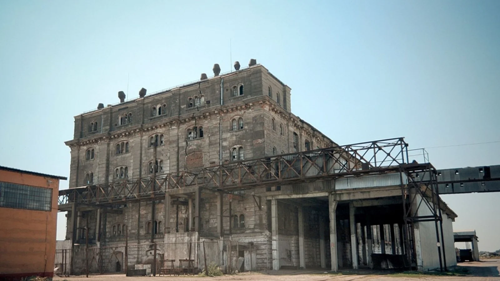
We close with the most underrated place in the whole top. In 1888, in the docks of Brăila, a 34-year-old engineer named Anghel Saligny achieved a world first: the first large-scale reinforced concrete silos, only 20 years after Monier's patent, at a time when the material was still considered an exhibition curiosity. The main warehouse, a monolith of 120 by 30 meters with 336 cells of 50-100 tons each, served the largest grain port on the Lower Danube: the wheat of the Bărăgan plain left from here for all of Europe. Saligny would become famous with the Cernavodă bridge, but in Brăila he quietly staged his rehearsal of genius.
After 1989, Brăila's grain trade collapsed and the silos were abandoned altogether: the empty cells resonate like concrete organs, the walkways are rusting, and trees grow on the facades. The fact that a world-class engineering monument, cited in the histories of reinforced concrete, sits unused in a European port says everything about how Romania treats its industrial heritage. In practical terms: the silos stand in the active port area, with varying access rules, so check the situation on site and do not force gates or fences: the perimeter shifts depending on the port operators. Even seen only from the quay or the Danube promenade, they are worth the trip. The rest of the port city, with its dead factories and mills, is on the map of abandoned places in Romania.
FAQ - Urbex Romania: frequently asked questions
Is urbex legal in Romania?
Exploring in itself is not a crime, but almost every abandoned place has an owner, whether private, the town hall or the state, and entering a building without permission can qualify as trespassing on a home or on business premises (articles 224-225 of the Romanian Penal Code). In practice, places like Lindenfeld, Geamăna or the Călimani quarry can be visited freely, while the Govora Pavilion or the Brăila silos call for caution and, sometimes, walking away. Our rules are fixed: never force a door or a fence, take nothing and break nothing, and if you are asked to leave, you leave. Take only photos, leave only footprints.
What is the most famous abandoned place in Romania?
Internationally, the iconic photo is the sunken church of Geamăna, published all over the world as the image of the Roșia Poieni ecological disaster. At home, the crown belongs to the Neptun Baths in Băile Herculane, the "queen of ruins", listed by Europa Nostra among Europe's most endangered monuments. It is no accident that these two open our top: they are the perfect entry points into Romanian urbex, both with free coordinates on the Romania map.
How do you get the GPS coordinates of these places?
Under every place in this article there is a card with the "Add to my map" button. One click and the exact GPS coordinates are saved to your personal map, free and with no credit card. From there you open them straight in your navigation app and build your routes region by region. All saved places also show up on the free urbex map, along with the rest of the more than 1,100 geolocated abandoned places in Romania.
What is the most dangerous place on this list?
No contest: Geamăna. The tailings pond sludge is toxic and unstable, the surface crust can give way under a person, and the pond is active and rising by about one meter per year, so stay on the slopes and on the road. In second place, the Crivina power plant: rusted metal structures tens of meters tall, unsecured openings and uncertain floors. The basic rules everywhere: never explore alone, tell someone where you are, wear boots and carry a flashlight, do not lean on railings, and treat every upper floor as rotten until proven otherwise.
Can some of these places be visited legally?
Yes, and not just a few. The Călimani sulfur quarry is a free hike through the national park, as long as you follow the rules of the protected area. Lindenfeld is a deserted village freely reached by forest road, and Geamăna can be viewed legally and safely from the slopes and from the Lupșa road. At the Neptun Baths, the exterior and the promenade are open, only the interior is sealed off. For Călan and Govăjdia, the terrain is practically open. That leaves the sensitive cases, Govora, Marila and Brăila, where the status has to be checked on site and where a no is a valid answer.
Why does Romania have so many abandoned places?
Four mechanisms piled up. Post-1989 deindustrialization: complexes like Victoria Călan or plants like Anina died together with the planned economy. Blocked restitutions: thousands of buildings, from the Neptun Baths to the Govora Pavilion, spent decades in court, and during that time nobody invested a cent. Rural depopulation, which empties entire villages like Lindenfeld. And scrap metal looting, which turns any unguarded industrial site into a metal quarry. The result is a density of authentic ruins that few European countries still have, and that is exactly what we document on the map.
What is the best season for urbex in Romania?
It depends on the terrain. For the mountain sites, Călimani, Lindenfeld and Marila, the good window runs from May to October: the forest roads become impassable at snowmelt, and the sulfur quarry sits under snow half the year. For urban and industrial sites, Călan, Brăila and Govora, late autumn and winter are your allies: the vegetation drops and reveals the structures, and the low light makes for better photos. At Geamăna, avoid rainy spells, when the sludge gets even more treacherous. In summer, mind the one real enemy inside buildings: wasps.
How can you contribute to the map?
Our community of over 40,000 explorers has run on contributions since 2021: you find a place that is not on the map, you submit it with coordinates and a few photos, and a regional moderator checks it before publication, every coordinate passing through at least two validations. Free places, like the 10 above, coexist with the paid packs that fund this work. Start simple: create your personal map, save the places from this top and add what you discover in the field. That is how the Romania map grew past 1,100 places.
Conclusion: explore the map of abandoned places in Romania
The 10 places above are the tip of the iceberg, but also an X-ray of the country: post-1989 deindustrialization left behind entire complexes, power plants and mines, restitutions stuck in the courts condemned imperial baths and spa pavilions to decades of decay, rural depopulation empties villages like Lindenfeld, and scrap metal thieves shave off, year after year, what is left. The window in which you can see all of this is closing: some places will be restored, as in Constanța, others will simply disappear, as in Doicești. Start from the map of abandoned places in Romania, with over 1,100 geolocated spots, continue with the city guides for Bucharest, Cluj-Napoca, Timișoara, Iași and Constanța, save your favorites to your map and get out there. With respect for the places, for the people guarding their memory, and for your own safety.